Leiblfing elevation
Leiblfing (Bavaria, Lower Bavaria), Germany elevation is 362 meters and Leiblfing elevation in feet is 1188 ft above sea level [src 1]. Leiblfing is a seat of a fourth-order administrative division (feature code) with elevation that is 104 meters (341 ft) bigger than average city elevation in Germany.
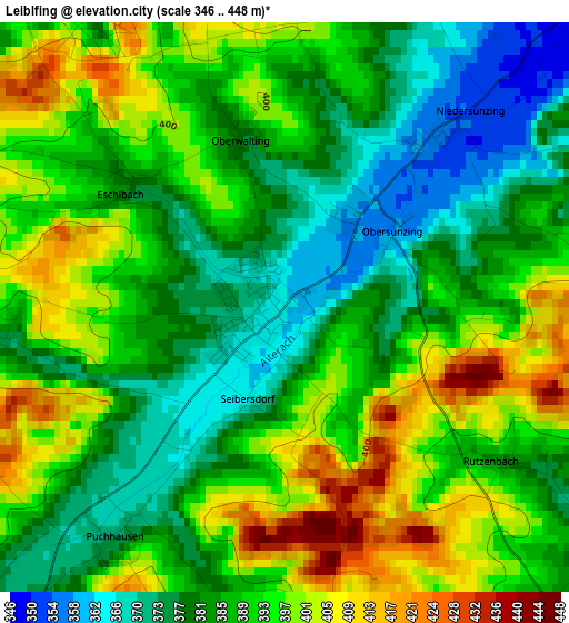
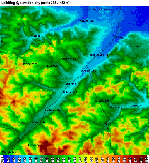
Below is the Elevation map of Leiblfing, which displays elevation range with different colors. Scale of the first map is from 346 to 448 m (1135 to 1470 ft) with average elevation of 388.5 meters (=1275 ft) [note 1]
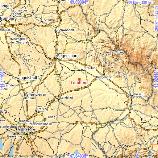
These maps also provides idea of topography and contour of this city, they are displayed at different zoom levels. More info about maps, scale and edge coordinates you can find below images.
| \ | Map #1 | Map #2 | Topo.Map |
| Scale [m] | 346..448 m | 335..482 m | × |
| Scale [ft] | 1135..1470 ft | 1099..1581 ft | × |
| Average | 388.5 m = 1275 ft | 392.7 m = 1288 ft | × |
| Width | 6.44 km = 4 mi | 12.88 km = 8 mi | 206.1 km = 128.1 mi |
| Height | 6.44 km = 4 mi | 12.88 km = 8 mi | 206.1 km = 128.1 mi |
| ↑Max Latitude | 48.804602° | 48.833537° | 49.69384° |
| Latitude at center | 48.77565° | 48.77565° | 48.77565° |
| ↓Min Latitude | 48.746681° | 48.717696° | 47.84035° |
| ← Min Longitude | 12.473985° | 12.430039° | 11.11168° |
| Longitude center | 12.51793° | 12.51793° | 12.51793° |
| →Max Longitude | 12.561875° | 12.605821° | 13.92418° |
Nearby cities:
Cities around Leiblfing sort by population:
• Straubing elevation 333 m
12.4 km,  19°
19°
• Dingolfing 357 m
14.9 km,  187°
187°
• Geiselhöring 356 m
10.5 km,  301°
301°
• Pilsting 343 m
12.8 km,  130°
130°
• Mengkofen 399 m
8.5 km,  222°
222°
• Moosthenning 369 m
11.1 km, 187°
• Alterhofen 331 m
10.9 km,  43°
43°
• Oberschneiding 359 m
9.4 km,  76°
76°
• Rain 332 m
14.8 km,  345°
345°
• Salching 348 m
5.5 km, 44°
• Atting 334 m
13.4 km, 350°
• Perkam 356 m
10.5 km,  327°
327°
Multilingual:
 En español:
Leiblfing elevación 362 m.
 En France:
Leiblfing élévation 362 m.
 Auf Deutsch:
Leiblfing höhe über dem Meeresspiegel ist 362 m.

Sources and notes:
- [note 1] Map square and city borders are not equal. Map elevation data is calculated only from area inside that square.
- [src 1] Elevation data from geonames database provided with same terms of usage.
- [src 2] The elevation map of Leiblfing is generated using elevation data from NASA's 3 arcsec (90m) resolution SRTM data.
- [src 3] Base (background) map © OpenStreetMap contributors tiles are generated by Geofabrik and OpenTopoMap.
Copyright & License:
This Leiblfing Elevation Map is licensed under CC BY-SA. You may reuse any part from this page, if you give a proper credit by linking to this URL:
 More info on terms of use page.