Leutenberg elevation
Leutenberg (Thuringia), Germany elevation is 290 meters and Leutenberg elevation in feet is 951 ft above sea level [src 1]. Leutenberg is a populated place (feature code) with elevation that is 32 meters (105 ft) bigger than average city elevation in Germany.
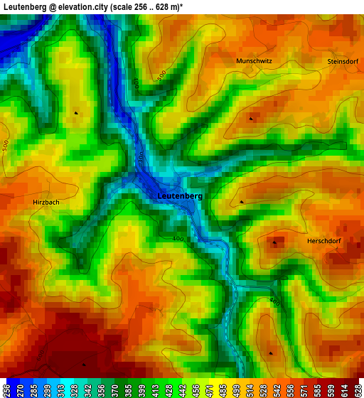
Below is the Elevation map of Leutenberg, which displays elevation range with different colors. Scale of the first map is from 256 to 628 m (840 to 2060 ft) with average elevation of 466.3 meters (=1530 ft) [note 1]
These maps also provides idea of topography and contour of this city, they are displayed at different zoom levels. More info about maps, scale and edge coordinates you can find below images.
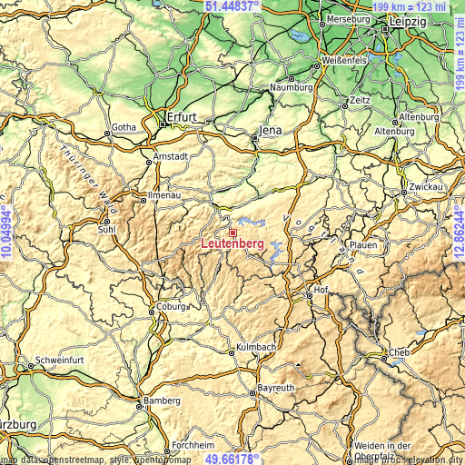
| \ | Map #1 | Topo.Map |
| Scale [m] | 256..628 m | × |
| Scale [ft] | 840..2060 ft | × |
| Average | 466.3 m = 1530 ft | × |
| Width | 6.21 km = 3.9 mi | 198.7 km = 123.5 mi |
| Height | 6.21 km = 3.9 mi | 198.6 km = 123.4 mi |
| ↑Max Latitude | 50.591447° | 51.44837° |
| Latitude at center | 50.56354° | 50.56354° |
| ↓Min Latitude | 50.535617° | 49.66178° |
| ← Min Longitude | 11.412245° | 10.04994° |
| Longitude center | 11.45619° | 11.45619° |
| →Max Longitude | 11.500135° | 12.86244° |
Nearby cities:
Cities around Leutenberg sort by population:
• Saalfeld elevation 230 m
11.4 km,  325°
325°
• Remptendorf 522 m
14.1 km,  103°
103°
• Wurzbach 526 m
12.5 km,  152°
152°
• Ludwigsstadt 443 m
9.9 km,  209°
209°
• Krölpa 248 m
13.9 km,  24°
24°
• Probstzella 378 m
6.1 km,  236°
236°
• Unterwellenborn 295 m
9.7 km,  350°
350°
• Kaulsdorf 250 m
6.1 km,  344°
344°
• Kamsdorf 355 m
8.8 km,  359°
359°
• Ranis 383 m
13.5 km,  36°
36°
• Könitz 332 m
9.9 km,  13°
13°
• Goßwitz 422 m
8.1 km, 10°
Multilingual:
 En español:
Leutenberg elevación 290 m.
 En France:
Leutenberg élévation 290 m.
 Auf Deutsch:
Leutenberg höhe über dem Meeresspiegel ist 290 m.

Sources and notes:
- [note 1] Map square and city borders are not equal. Map elevation data is calculated only from area inside that square.
- [src 1] Elevation data from geonames database provided with same terms of usage.
- [src 2] The elevation map of Leutenberg is generated using elevation data from NASA's 3 arcsec (90m) resolution SRTM data.
- [src 3] Base (background) map © OpenStreetMap contributors tiles are generated by Geofabrik and OpenTopoMap.
Copyright & License:
This Leutenberg Elevation Map is licensed under CC BY-SA. You may reuse any part from this page, if you give a proper credit by linking to this URL:
 More info on terms of use page.