Lichte elevation
Lichte (Thuringia), Germany elevation is 652 meters and Lichte elevation in feet is 2139 ft above sea level [src 1]. Lichte is a seat of a fourth-order administrative division (feature code) with elevation that is 394 meters (1293 ft) bigger than average city elevation in Germany.
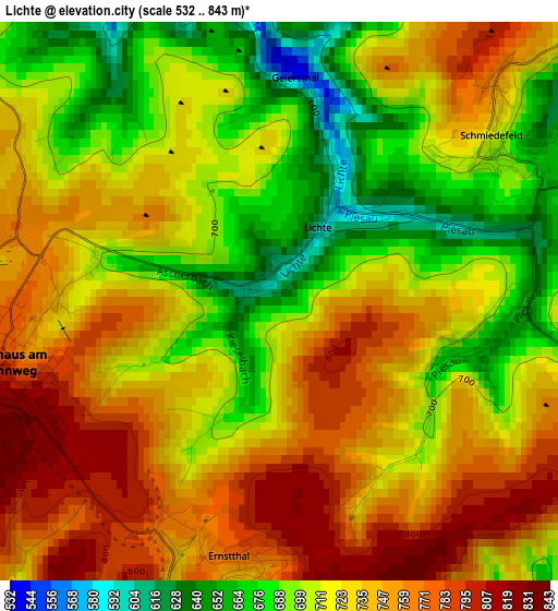
Below is the Elevation map of Lichte, which displays elevation range with different colors. Scale of the first map is from 532 to 843 m (1745 to 2766 ft) with average elevation of 724.1 meters (=2376 ft) [note 1]
These maps also provides idea of topography and contour of this city, they are displayed at different zoom levels. More info about maps, scale and edge coordinates you can find below images.
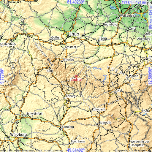
| \ | Map #1 | Topo.Map |
| Scale [m] | 532..843 m | × |
| Scale [ft] | 1745..2766 ft | × |
| Average | 724.1 m = 2376 ft | × |
| Width | 6.21 km = 3.9 mi | 198.8 km = 123.5 mi |
| Height | 6.21 km = 3.9 mi | 198.8 km = 123.5 mi |
| ↑Max Latitude | 50.544605° | 51.40239° |
| Latitude at center | 50.51667° | 50.51667° |
| ↓Min Latitude | 50.488719° | 49.61402° |
| ← Min Longitude | 11.139385° | 9.77708° |
| Longitude center | 11.18333° | 11.18333° |
| →Max Longitude | 11.227275° | 12.58958° |
Nearby cities:
Cities around Lichte sort by population:
• Neuhaus am Rennweg elevation 800 m
3.3 km,  257°
257°
• Steinach 492 m
9.6 km,  190°
190°
• Lauscha 635 m
4.7 km,  200°
200°
• Judenbach 630 m
13.7 km,  168°
168°
• Tettau 632 m
7.5 km,  134°
134°
• Katzhütte 430 m
10 km,  293°
293°
• Oberweißbach 634 m
7.8 km,  339°
339°
• Meuselbach 583 m
8.9 km,  313°
313°
• Steinheid 807 m
9.1 km,  231°
231°
• Schmiedefeld 710 m
3 km,  51°
51°
• Mellenbach-Glasbach 600 m
12.6 km,  332°
332°
• Sitzendorf 307 m
12.8 km,  356°
356°
Multilingual:
 En español:
Lichte elevación 652 m.
 En France:
Lichte élévation 652 m.


Sources and notes:
- [note 1] Map square and city borders are not equal. Map elevation data is calculated only from area inside that square.
- [src 1] Elevation data from geonames database provided with same terms of usage.
- [src 2] The elevation map of Lichte is generated using elevation data from NASA's 3 arcsec (90m) resolution SRTM data.
- [src 3] Base (background) map © OpenStreetMap contributors tiles are generated by Geofabrik and OpenTopoMap.
Copyright & License:
This Lichte Elevation Map is licensed under CC BY-SA. You may reuse any part from this page, if you give a proper credit by linking to this URL:
 More info on terms of use page.