Limbach-Oberfrohna elevation
Limbach-Oberfrohna (Saxony), Germany elevation is 358 meters and Limbach-Oberfrohna elevation in feet is 1175 ft above sea level [src 1]. Limbach-Oberfrohna is a populated place (feature code) with elevation that is 100 meters (328 ft) bigger than average city elevation in Germany.
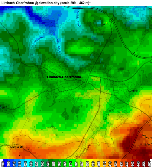
Below is the Elevation map of Limbach-Oberfrohna, which displays elevation range with different colors. Scale of the first map is from 299 to 462 m (981 to 1516 ft) with average elevation of 370.6 meters (=1216 ft) [note 1]
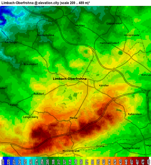
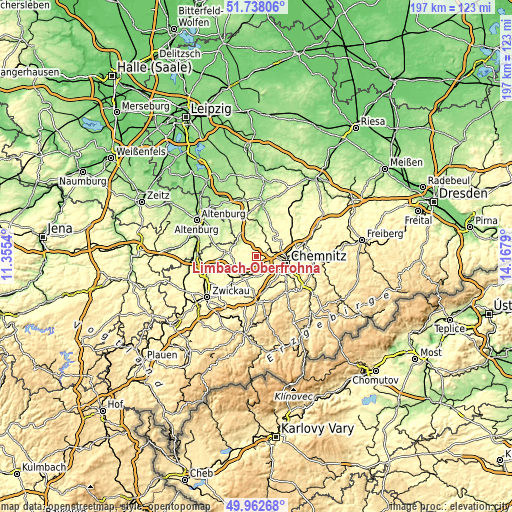
These maps also provides idea of topography and contour of this city, they are displayed at different zoom levels. More info about maps, scale and edge coordinates you can find below images.
| \ | Map #1 | Map #2 | Topo.Map |
| Scale [m] | 299..462 m | 209..489 m | × |
| Scale [ft] | 981..1516 ft | 686..1604 ft | × |
| Average | 370.6 m = 1216 ft | 353.8 m = 1161 ft | × |
| Width | 6.17 km = 3.8 mi | 12.34 km = 7.7 mi | 197.4 km = 122.7 mi |
| Height | 6.17 km = 3.8 mi | 12.34 km = 7.7 mi | 197.4 km = 122.7 mi |
| ↑Max Latitude | 50.886551° | 50.914267° | 51.73806° |
| Latitude at center | 50.85882° | 50.85882° | 50.85882° |
| ↓Min Latitude | 50.831072° | 50.803307° | 49.96268° |
| ← Min Longitude | 12.717705° | 12.673759° | 11.3554° |
| Longitude center | 12.76165° | 12.76165° | 12.76165° |
| →Max Longitude | 12.805595° | 12.849541° | 14.1679° |
Nearby cities:
Cities around Limbach-Oberfrohna sort by population:
• Hohenstein-Ernstthal elevation 361 m
7.3 km,  207°
207°
• Burgstädt 323 m
6.8 km,  27°
27°
• Penig 207 m
9.2 km,  334°
334°
• Neukirchen 354 m
11.5 km,  139°
139°
• Oberlungwitz 300 m
9.3 km,  203°
203°
• Callenberg 328 m
9.1 km,  263°
263°
• Hartmannsdorf 304 m
5.3 km, 30°
• Wittgensdorf 312 m
8.1 km,  70°
70°
• Taura 298 m
8.9 km,  43°
43°
• Niederfrohna 283 m
5.6 km, 325°
• Mühlau 336 m
4.6 km,  4°
4°
• Kirchberg 388 m
10.8 km,  178°
178°
Multilingual:
 En español:
Limbach-Oberfrohna elevación 358 m.
 En France:
Limbach-Oberfrohna élévation 358 m.
 Auf Deutsch:
Limbach-Oberfrohna höhe über dem Meeresspiegel ist 358 m.

Sources and notes:
- [note 1] Map square and city borders are not equal. Map elevation data is calculated only from area inside that square.
- [src 1] Elevation data from geonames database provided with same terms of usage.
- [src 2] The elevation map of Limbach-Oberfrohna is generated using elevation data from NASA's 3 arcsec (90m) resolution SRTM data.
- [src 3] Base (background) map © OpenStreetMap contributors tiles are generated by Geofabrik and OpenTopoMap.
Copyright & License:
This Limbach-Oberfrohna Elevation Map is licensed under CC BY-SA. You may reuse any part from this page, if you give a proper credit by linking to this URL:
 More info on terms of use page.