Lindwedel elevation
Lindwedel (Lower Saxony), Germany elevation is 38 meters and Lindwedel elevation in feet is 125 ft above sea level [src 1]. Lindwedel is a seat of a fourth-order administrative division (feature code) with elevation that is 220 meters (722 ft) smaller than average city elevation in Germany.
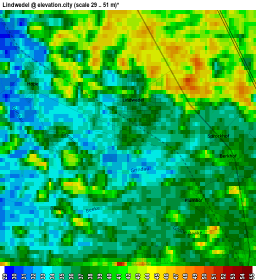
Below is the Elevation map of Lindwedel, which displays elevation range with different colors. Scale of the first map is from 29 to 51 m (95 to 167 ft) with average elevation of 37.4 meters (=123 ft) [note 1]
These maps also provides idea of topography and contour of this city, they are displayed at different zoom levels. More info about maps, scale and edge coordinates you can find below images.
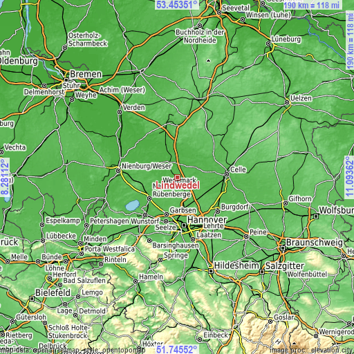
| \ | Map #1 | Topo.Map |
| Scale [m] | 29..51 m | × |
| Scale [ft] | 95..167 ft | × |
| Average | 37.4 m = 123 ft | × |
| Width | 5.93 km = 3.7 mi | 189.9 km = 118 mi |
| Height | 5.93 km = 3.7 mi | 189.9 km = 118 mi |
| ↑Max Latitude | 52.634518° | 53.45351° |
| Latitude at center | 52.60784° | 52.60784° |
| ↓Min Latitude | 52.581145° | 51.74552° |
| ← Min Longitude | 9.643425° | 8.28112° |
| Longitude center | 9.68737° | 9.68737° |
| →Max Longitude | 9.731315° | 11.09362° |
Nearby cities:
Cities around Lindwedel sort by population:
• Langenhagen elevation 54 m
18.1 km,  169°
169°
• Neustadt am Rübenberge 42 m
19.3 km,  233°
233°
• Isernhagen Farster Bauerschaft 83 m
18.5 km,  145°
145°
• Winsen 33 m
17.4 km,  61°
61°
• Hambühren 35 m
20.2 km,  81°
81°
• Wietze 34 m
10.9 km, 64°
• Schwarmstedt 30 m
9.1 km,  328°
328°
• Hodenhagen 26 m
18.6 km,  340°
340°
• Elze 39 m
4.3 km,  132°
132°
• Ahlden 25 m
19.2 km, 331°
• Gilten 21 m
12.4 km, 325°
• Essel 28 m
9.8 km, 341°
Multilingual:
 En español:
Lindwedel elevación 38 m.
 En France:
Lindwedel élévation 38 m.
 Auf Deutsch:
Lindwedel höhe über dem Meeresspiegel ist 38 m.

Sources and notes:
- [note 1] Map square and city borders are not equal. Map elevation data is calculated only from area inside that square.
- [src 1] Elevation data from geonames database provided with same terms of usage.
- [src 2] The elevation map of Lindwedel is generated using elevation data from NASA's 3 arcsec (90m) resolution SRTM data.
- [src 3] Base (background) map © OpenStreetMap contributors tiles are generated by Geofabrik and OpenTopoMap.
Copyright & License:
This Lindwedel Elevation Map is licensed under CC BY-SA. You may reuse any part from this page, if you give a proper credit by linking to this URL:
 More info on terms of use page.