Lohr am Main elevation
Lohr am Main (Bavaria, Regierungsbezirk Unterfranken), Germany elevation is 167 meters and Lohr am Main elevation in feet is 548 ft above sea level [src 1]. Lohr am Main is a populated place (feature code) with elevation that is 91 meters (299 ft) smaller than average city elevation in Germany.
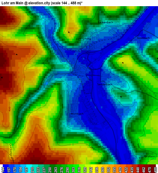
Below is the Elevation map of Lohr am Main, which displays elevation range with different colors. Scale of the first map is from 144 to 488 m (472 to 1601 ft) with average elevation of 270.6 meters (=888 ft) [note 1]
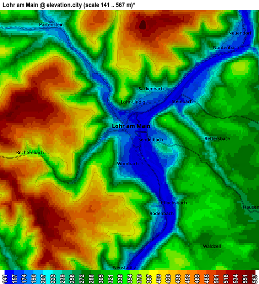
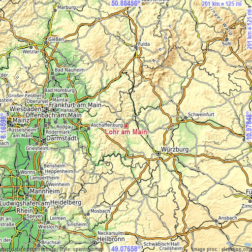
These maps also provides idea of topography and contour of this city, they are displayed at different zoom levels. More info about maps, scale and edge coordinates you can find below images.
| \ | Map #1 | Map #2 | Topo.Map |
| Scale [m] | 144..488 m | 141..567 m | × |
| Scale [ft] | 472..1601 ft | 463..1860 ft | × |
| Average | 270.6 m = 888 ft | 336.1 m = 1103 ft | × |
| Width | 6.28 km = 3.9 mi | 12.57 km = 7.8 mi | 201.1 km = 125 mi |
| Height | 6.28 km = 3.9 mi | 12.57 km = 7.8 mi | 201 km = 124.9 mi |
| ↑Max Latitude | 50.017466° | 50.045694° | 50.88486° |
| Latitude at center | 49.98922° | 49.98922° | 49.98922° |
| ↓Min Latitude | 49.960958° | 49.932679° | 49.07658° |
| ← Min Longitude | 9.528285° | 9.484339° | 8.16598° |
| Longitude center | 9.57223° | 9.57223° | 9.57223° |
| →Max Longitude | 9.616175° | 9.660121° | 10.97848° |
Nearby cities:
Cities around Lohr am Main sort by population:
• Gemünden am Main elevation 179 m
11.7 km,  54°
54°
• Frammersbach 228 m
11.2 km,  318°
318°
• Partenstein 202 m
6.9 km,  327°
327°
• Erlenbach 283 m
5.3 km,  102°
102°
• Steinfeld 279 m
8 km,  120°
120°
• Wiesthal 274 m
11.1 km,  296°
296°
• Urspringen 276 m
12 km,  143°
143°
• Neustadt am Main 160 m
6.6 km,  182°
182°
• Neuhütten 335 m
11.2 km,  276°
276°
• Roden 253 m
11.1 km,  159°
159°
• Rothenfels 152 m
11 km,  172°
172°
• Rechtenbach 345 m
4.6 km,  261°
261°
Multilingual:
 En español:
Lohr am Main elevación 167 m.
 En France:
Lohr am Main élévation 167 m.
 Auf Deutsch:
Lohr am Main höhe über dem Meeresspiegel ist 167 m.

Sources and notes:
- [note 1] Map square and city borders are not equal. Map elevation data is calculated only from area inside that square.
- [src 1] Elevation data from geonames database provided with same terms of usage.
- [src 2] The elevation map of Lohr am Main is generated using elevation data from NASA's 3 arcsec (90m) resolution SRTM data.
- [src 3] Base (background) map © OpenStreetMap contributors tiles are generated by Geofabrik and OpenTopoMap.
Copyright & License:
This Lohr am Main Elevation Map is licensed under CC BY-SA. You may reuse any part from this page, if you give a proper credit by linking to this URL:
 More info on terms of use page.