Masburg elevation
Masburg (Rheinland-Pfalz), Germany elevation is 490 meters and Masburg elevation in feet is 1608 ft above sea level [src 1]. Masburg is a seat of a fourth-order administrative division (feature code) with elevation that is 232 meters (761 ft) bigger than average city elevation in Germany.
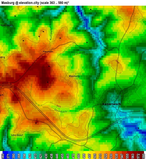
Below is the Elevation map of Masburg, which displays elevation range with different colors. Scale of the first map is from 363 to 580 m (1191 to 1903 ft) with average elevation of 477.8 meters (=1568 ft) [note 1]
These maps also provides idea of topography and contour of this city, they are displayed at different zoom levels. More info about maps, scale and edge coordinates you can find below images.
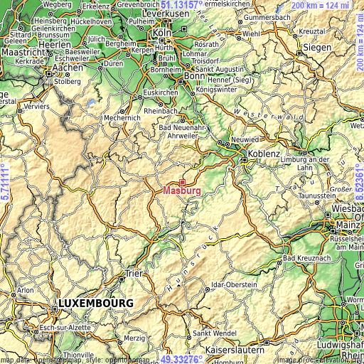
| \ | Map #1 | Topo.Map |
| Scale [m] | 363..580 m | × |
| Scale [ft] | 1191..1903 ft | × |
| Average | 477.8 m = 1568 ft | × |
| Width | 6.25 km = 3.9 mi | 200 km = 124.3 mi |
| Height | 6.25 km = 3.9 mi | 200 km = 124.3 mi |
| ↑Max Latitude | 50.268748° | 51.13157° |
| Latitude at center | 50.24065° | 50.24065° |
| ↓Min Latitude | 50.212536° | 49.33276° |
| ← Min Longitude | 7.073415° | 5.71111° |
| Longitude center | 7.11736° | 7.11736° |
| →Max Longitude | 7.161305° | 8.52361° |
Nearby cities:
Cities around Masburg sort by population:
• Mayen elevation 238 m
12.3 km,  37°
37°
• Cochem 110 m
11.1 km,  162°
162°
• Ulmen 429 m
10.4 km,  250°
250°
• Kaisersesch 423 m
1.8 km,  123°
123°
• Mertloch 196 m
13.9 km,  76°
76°
• Klotten 135 m
10.1 km,  144°
144°
• Düngenheim 469 m
4.1 km,  56°
56°
• Faid 391 m
10.7 km,  179°
179°
• Büchel 451 m
7.9 km,  197°
197°
• Kehrig 362 m
8.5 km, 56°
• Ediger-Eller 344 m
14 km,  170°
170°
• Laubach 536 m
3.3 km, 254°
Multilingual:
 En español:
Masburg elevación 490 m.
 En France:
Masburg élévation 490 m.


Sources and notes:
- [note 1] Map square and city borders are not equal. Map elevation data is calculated only from area inside that square.
- [src 1] Elevation data from geonames database provided with same terms of usage.
- [src 2] The elevation map of Masburg is generated using elevation data from NASA's 3 arcsec (90m) resolution SRTM data.
- [src 3] Base (background) map © OpenStreetMap contributors tiles are generated by Geofabrik and OpenTopoMap.
Copyright & License:
This Masburg Elevation Map is licensed under CC BY-SA. You may reuse any part from this page, if you give a proper credit by linking to this URL:
 More info on terms of use page.