Maselheim elevation
Maselheim (Baden-Württemberg, Tübingen Region), Germany elevation is 544 meters and Maselheim elevation in feet is 1785 ft above sea level [src 1]. Maselheim is a seat of a fourth-order administrative division (feature code) with elevation that is 286 meters (938 ft) bigger than average city elevation in Germany.
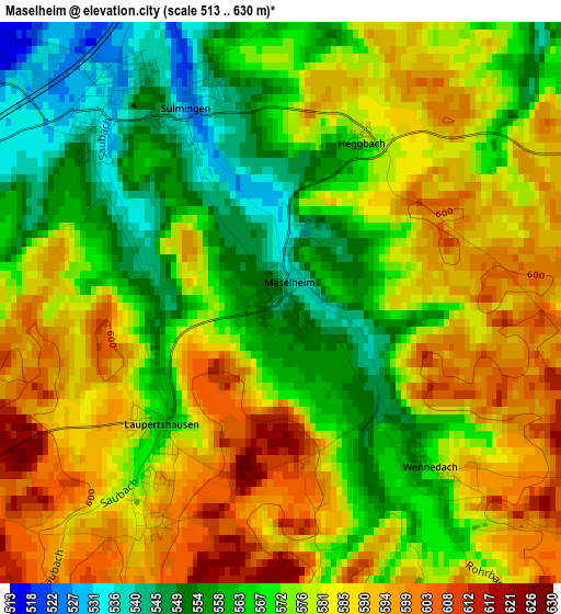
Below is the Elevation map of Maselheim, which displays elevation range with different colors. Scale of the first map is from 513 to 630 m (1683 to 2067 ft) with average elevation of 575.3 meters (=1887 ft) [note 1]
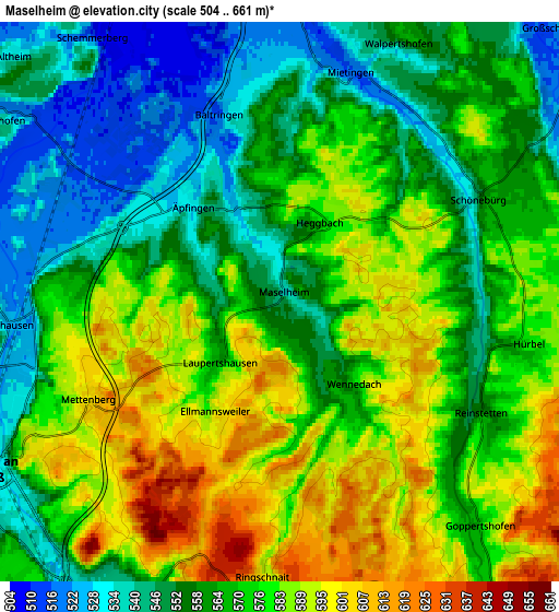
These maps also provides idea of topography and contour of this city, they are displayed at different zoom levels. More info about maps, scale and edge coordinates you can find below images.
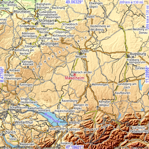
| \ | Map #1 | Map #2 | Topo.Map |
| Scale [m] | 513..630 m | 504..661 m | × |
| Scale [ft] | 1683..2067 ft | 1654..2169 ft | × |
| Average | 575.3 m = 1887 ft | 569.3 m = 1868 ft | × |
| Width | 6.52 km = 4.1 mi | 13.04 km = 8.1 mi | 208.7 km = 129.7 mi |
| Height | 6.52 km = 4.1 mi | 13.04 km = 8.1 mi | 208.7 km = 129.7 mi |
| ↑Max Latitude | 48.162651° | 48.191955° | 49.06329° |
| Latitude at center | 48.13333° | 48.13333° | 48.13333° |
| ↓Min Latitude | 48.103993° | 48.074638° | 47.18621° |
| ← Min Longitude | 9.839385° | 9.795439° | 8.47708° |
| Longitude center | 9.88333° | 9.88333° | 9.88333° |
| →Max Longitude | 9.927275° | 9.971221° | 11.28958° |
Nearby cities:
Cities around Maselheim sort by population:
• Biberach an der Riß elevation 535 m
8.2 km,  237°
237°
• Laupheim 504 m
10.5 km,  358°
358°
• Ochsenhausen 579 m
8.6 km,  144°
144°
• Schwendi 528 m
8.2 km,  56°
56°
• Warthausen 528 m
6.4 km,  265°
265°
• Ummendorf 551 m
8.3 km,  206°
206°
• Mietingen 517 m
5.7 km,  12°
12°
• Mittelbiberach 577 m
11.4 km, 240°
• Burgrieden 503 m
11.7 km,  18°
18°
• Gutenzell-Hürbel 571 m
7.6 km,  104°
104°
• Erlenmoos 639 m
10.2 km, 137°
• Wain 545 m
11.9 km, 58°
Multilingual:
 En español:
Maselheim elevación 544 m.
 En France:
Maselheim élévation 544 m.
 Auf Deutsch:
Maselheim höhe über dem Meeresspiegel ist 544 m.

Sources and notes:
- [note 1] Map square and city borders are not equal. Map elevation data is calculated only from area inside that square.
- [src 1] Elevation data from geonames database provided with same terms of usage.
- [src 2] The elevation map of Maselheim is generated using elevation data from NASA's 3 arcsec (90m) resolution SRTM data.
- [src 3] Base (background) map © OpenStreetMap contributors tiles are generated by Geofabrik and OpenTopoMap.
Copyright & License:
This Maselheim Elevation Map is licensed under CC BY-SA. You may reuse any part from this page, if you give a proper credit by linking to this URL:
 More info on terms of use page.