Mölln elevation
Mölln (Schleswig-Holstein), Germany elevation is 39 meters and Mölln elevation in feet is 128 ft above sea level [src 1]. Mölln is a populated place (feature code) with elevation that is 219 meters (719 ft) smaller than average city elevation in Germany.
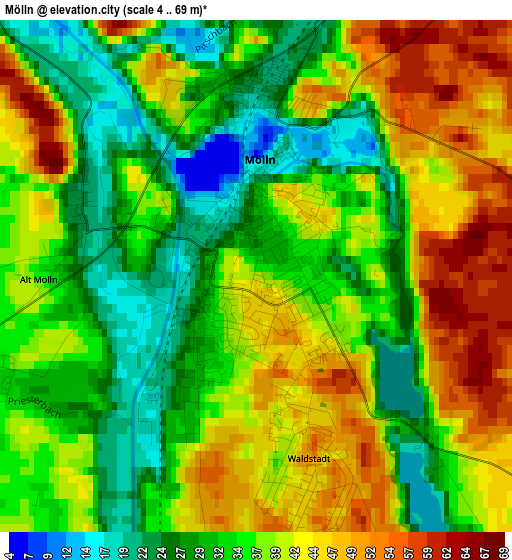
Below is the Elevation map of Mölln, which displays elevation range with different colors. Scale of the first map is from 4 to 69 m (13 to 226 ft) with average elevation of 36.5 meters (=120 ft) [note 1]
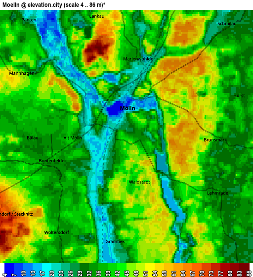
These maps also provides idea of topography and contour of this city, they are displayed at different zoom levels. More info about maps, scale and edge coordinates you can find below images.
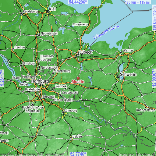
| \ | Map #1 | Map #2 | Topo.Map |
| Scale [m] | 4..69 m | 4..86 m | × |
| Scale [ft] | 13..226 ft | 13..282 ft | × |
| Average | 36.5 m = 120 ft | 39.4 m = 129 ft | × |
| Width | 5.8 km = 3.6 mi | 11.59 km = 7.2 mi | 185.5 km = 115.3 mi |
| Height | 5.8 km = 3.6 mi | 11.59 km = 7.2 mi | 185.5 km = 115.3 mi |
| ↑Max Latitude | 53.643079° | 53.669123° | 54.44296° |
| Latitude at center | 53.61702° | 53.61702° | 53.61702° |
| ↓Min Latitude | 53.590944° | 53.564853° | 52.7746° |
| ← Min Longitude | 10.643475° | 10.599529° | 9.28117° |
| Longitude center | 10.68742° | 10.68742° | 10.68742° |
| →Max Longitude | 10.731365° | 10.775311° | 12.09367° |
Nearby cities:
Cities around Mölln sort by population:
• Ratzeburg elevation 13 m
10.8 km,  31°
31°
• Büchen 17 m
15.9 km,  196°
196°
• Zarrentin 46 m
16.8 km,  116°
116°
• Berkenthin 9 m
13.2 km,  349°
349°
• Breitenfelde 32 m
3.8 km,  250°
250°
• Gudow 31 m
8.7 km,  141°
141°
• Sandesneben 46 m
14.4 km,  300°
300°
• Güster 18 m
8.8 km,  184°
184°
• Linau 69 m
14.8 km,  281°
281°
• Kastorf 29 m
16.4 km,  331°
331°
• Schlagsdorf 43 m
15.8 km,  35°
35°
• Nusse 37 m
8.1 km, 302°
Multilingual:
 En español:
Mölln elevación 39 m.
 En France:
Mölln élévation 39 m.


Sources and notes:
- [note 1] Map square and city borders are not equal. Map elevation data is calculated only from area inside that square.
- [src 1] Elevation data from geonames database provided with same terms of usage.
- [src 2] The elevation map of Mölln is generated using elevation data from NASA's 3 arcsec (90m) resolution SRTM data.
- [src 3] Base (background) map © OpenStreetMap contributors tiles are generated by Geofabrik and OpenTopoMap.
Copyright & License:
This Mölln Elevation Map is licensed under CC BY-SA. You may reuse any part from this page, if you give a proper credit by linking to this URL:
 More info on terms of use page.