Mühlacker elevation
Mühlacker (Baden-Württemberg, Karlsruhe Region), Germany elevation is 225 meters and Mühlacker elevation in feet is 738 ft above sea level [src 1]. Mühlacker is a populated place (feature code) with elevation that is 33 meters (108 ft) smaller than average city elevation in Germany.
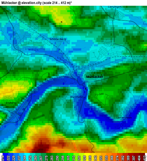
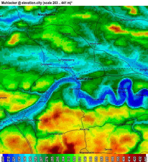
Below is the Elevation map of Mühlacker, which displays elevation range with different colors. Scale of the first map is from 214 to 412 m (702 to 1352 ft) with average elevation of 272.2 meters (=893 ft) [note 1]
These maps also provides idea of topography and contour of this city, they are displayed at different zoom levels. More info about maps, scale and edge coordinates you can find below images.
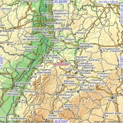
| \ | Map #1 | Map #2 | Topo.Map |
| Scale [m] | 214..412 m | 203..441 m | × |
| Scale [ft] | 702..1352 ft | 666..1447 ft | × |
| Average | 272.2 m = 893 ft | 294.8 m = 967 ft | × |
| Width | 6.42 km = 4 mi | 12.84 km = 8 mi | 205.4 km = 127.6 mi |
| Height | 6.42 km = 4 mi | 12.84 km = 8 mi | 205.4 km = 127.6 mi |
| ↑Max Latitude | 48.976393° | 49.005229° | 49.86256° |
| Latitude at center | 48.94754° | 48.94754° | 48.94754° |
| ↓Min Latitude | 48.918671° | 48.889784° | 48.01543° |
| ← Min Longitude | 8.792805° | 8.748859° | 7.4305° |
| Longitude center | 8.83675° | 8.83675° | 8.83675° |
| →Max Longitude | 8.880695° | 8.924641° | 10.243° |
Nearby cities:
Cities around Mühlacker sort by population:
• Vaihingen an der Enz elevation 237 m
9.1 km,  98°
98°
• Niefern-Öschelbronn 241 m
5.2 km,  228°
228°
• Knittlingen 190 m
10.4 km,  325°
325°
• Illingen 231 m
6.5 km,  81°
81°
• Maulbronn 247 m
6.3 km,  337°
337°
• Wiernsheim 423 m
7.2 km,  172°
172°
• Eutingen an der Enz 251 m
7.5 km,  238°
238°
• Ötisheim 237 m
3.4 km,  308°
308°
• Ölbronn-Dürrn 260 m
6.7 km,  288°
288°
• Wurmberg 448 m
9.1 km,  189°
189°
• Kieselbronn 370 m
6.5 km,  255°
255°
• Mönsheim 336 m
9.3 km, 166°
Multilingual:
 En español:
Mühlacker elevación 225 m.
 En France:
Mühlacker élévation 225 m.
 Auf Deutsch:
Mühlacker höhe über dem Meeresspiegel ist 225 m.

Sources and notes:
- [note 1] Map square and city borders are not equal. Map elevation data is calculated only from area inside that square.
- [src 1] Elevation data from geonames database provided with same terms of usage.
- [src 2] The elevation map of Mühlacker is generated using elevation data from NASA's 3 arcsec (90m) resolution SRTM data.
- [src 3] Base (background) map © OpenStreetMap contributors tiles are generated by Geofabrik and OpenTopoMap.
Copyright & License:
This Mühlacker Elevation Map is licensed under CC BY-SA. You may reuse any part from this page, if you give a proper credit by linking to this URL:
 More info on terms of use page.