Nauroth elevation
Nauroth (Rheinland-Pfalz), Germany elevation is 436 meters and Nauroth elevation in feet is 1430 ft above sea level [src 1]. Nauroth is a seat of a fourth-order administrative division (feature code) with elevation that is 178 meters (584 ft) bigger than average city elevation in Germany.
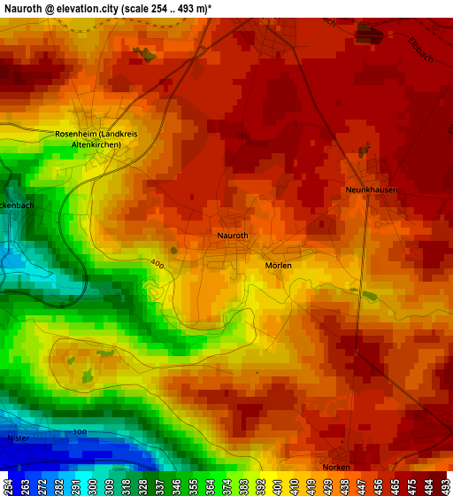
Below is the Elevation map of Nauroth, which displays elevation range with different colors. Scale of the first map is from 254 to 493 m (833 to 1617 ft) with average elevation of 423.5 meters (=1389 ft) [note 1]
These maps also provides idea of topography and contour of this city, they are displayed at different zoom levels. More info about maps, scale and edge coordinates you can find below images.
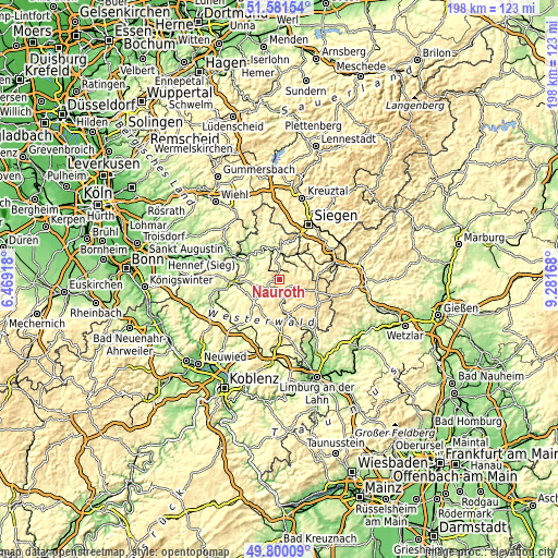
| \ | Map #1 | Topo.Map |
| Scale [m] | 254..493 m | × |
| Scale [ft] | 833..1617 ft | × |
| Average | 423.5 m = 1389 ft | × |
| Width | 6.19 km = 3.8 mi | 198.1 km = 123.1 mi |
| Height | 6.19 km = 3.8 mi | 198.1 km = 123.1 mi |
| ↑Max Latitude | 50.727096° | 51.58154° |
| Latitude at center | 50.69927° | 50.69927° |
| ↓Min Latitude | 50.671427° | 49.80009° |
| ← Min Longitude | 7.831485° | 6.46918° |
| Longitude center | 7.87543° | 7.87543° |
| →Max Longitude | 7.919375° | 9.28168° |
Nearby cities:
Cities around Nauroth sort by population:
• Hachenburg elevation 369 m
5.7 km,  220°
220°
• Daaden 355 m
7.5 km,  59°
59°
• Weitefeld 457 m
4.7 km,  51°
51°
• Unnau 382 m
6.1 km,  157°
157°
• Elkenroth 459 m
3.8 km,  8°
8°
• Gebhardshain 377 m
7 km,  323°
323°
• Alpenrod 431 m
7.4 km,  184°
184°
• Friedewald 456 m
6.1 km,  77°
77°
• Neunkhausen 453 m
2.1 km,  65°
65°
• Müschenbach 318 m
6.7 km,  254°
254°
• Nister 279 m
3.7 km,  225°
225°
• Niederdreisbach 294 m
6.5 km,  31°
31°
Multilingual:
 En español:
Nauroth elevación 436 m.
 En France:
Nauroth élévation 436 m.


Sources and notes:
- [note 1] Map square and city borders are not equal. Map elevation data is calculated only from area inside that square.
- [src 1] Elevation data from geonames database provided with same terms of usage.
- [src 2] The elevation map of Nauroth is generated using elevation data from NASA's 3 arcsec (90m) resolution SRTM data.
- [src 3] Base (background) map © OpenStreetMap contributors tiles are generated by Geofabrik and OpenTopoMap.
Copyright & License:
This Nauroth Elevation Map is licensed under CC BY-SA. You may reuse any part from this page, if you give a proper credit by linking to this URL:
 More info on terms of use page.