Neudietendorf elevation
Neudietendorf (Thuringia), Germany elevation is 242 meters and Neudietendorf elevation in feet is 794 ft above sea level [src 1]. Neudietendorf is a populated place (feature code) with elevation that is 16 meters (52 ft) smaller than average city elevation in Germany.
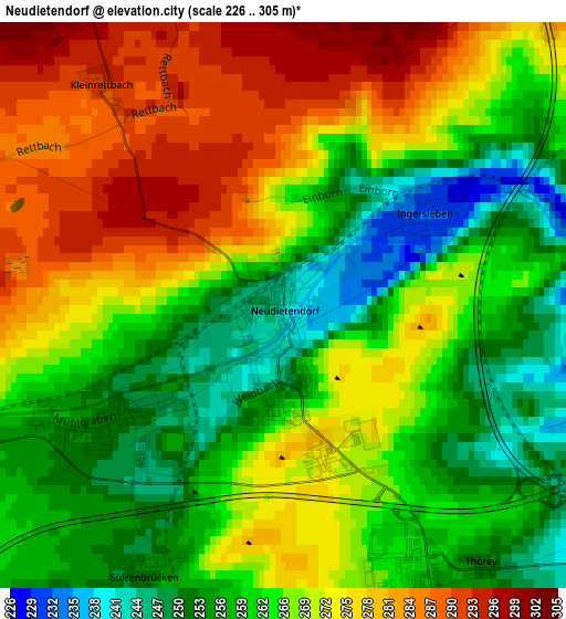
Below is the Elevation map of Neudietendorf, which displays elevation range with different colors. Scale of the first map is from 226 to 305 m (741 to 1001 ft) with average elevation of 266.8 meters (=875 ft) [note 1]
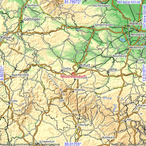
These maps also provides idea of topography and contour of this city, they are displayed at different zoom levels. More info about maps, scale and edge coordinates you can find below images.
| \ | Map #1 | Topo.Map |
| Scale [m] | 226..305 m | × |
| Scale [ft] | 741..1001 ft | × |
| Average | 266.8 m = 875 ft | × |
| Width | 6.16 km = 3.8 mi | 197.2 km = 122.5 mi |
| Height | 6.16 km = 3.8 mi | 197.2 km = 122.5 mi |
| ↑Max Latitude | 50.9402° | 51.79072° |
| Latitude at center | 50.9125° | 50.9125° |
| ↓Min Latitude | 50.884784° | 50.01739° |
| ← Min Longitude | 10.869515° | 9.50721° |
| Longitude center | 10.91346° | 10.91346° |
| →Max Longitude | 10.957405° | 12.31971° |
Nearby cities:
Cities around Neudietendorf sort by population:
• Erfurt elevation 195 m
11.1 km,  48°
48°
• Arnstadt 274 m
8.5 km,  161°
161°
• Ichtershausen 245 m
5.7 km,  135°
135°
• Wandersleben 265 m
4.7 km,  252°
252°
• Apfelstädt 251 m
2.1 km,  233°
233°
• Seebergen 287 m
8.1 km,  276°
276°
• Kirchheim 253 m
7.9 km,  114°
114°
• Friemar 287 m
11.3 km,  309°
309°
• Molschleben 290 m
13.3 km,  316°
316°
• Witterda 230 m
13.8 km,  353°
353°
• Grabsleben 292 m
6.1 km,  295°
295°
• Ingersleben 232 m
1.9 km,  57°
57°
Multilingual:
 En español:
Neudietendorf elevación 242 m.
 En France:
Neudietendorf élévation 242 m.
 Auf Deutsch:
Neudietendorf höhe über dem Meeresspiegel ist 242 m.

Sources and notes:
- [note 1] Map square and city borders are not equal. Map elevation data is calculated only from area inside that square.
- [src 1] Elevation data from geonames database provided with same terms of usage.
- [src 2] The elevation map of Neudietendorf is generated using elevation data from NASA's 3 arcsec (90m) resolution SRTM data.
- [src 3] Base (background) map © OpenStreetMap contributors tiles are generated by Geofabrik and OpenTopoMap.
Copyright & License:
This Neudietendorf Elevation Map is licensed under CC BY-SA. You may reuse any part from this page, if you give a proper credit by linking to this URL:
 More info on terms of use page.