Neustadt an der Aisch elevation
Neustadt an der Aisch (Bavaria, Regierungsbezirk Mittelfranken), Germany elevation is 309 meters and Neustadt an der Aisch elevation in feet is 1014 ft above sea level [src 1]. Neustadt an der Aisch is a seat of a third-order administrative division (feature code) with elevation that is 51 meters (167 ft) bigger than average city elevation in Germany.
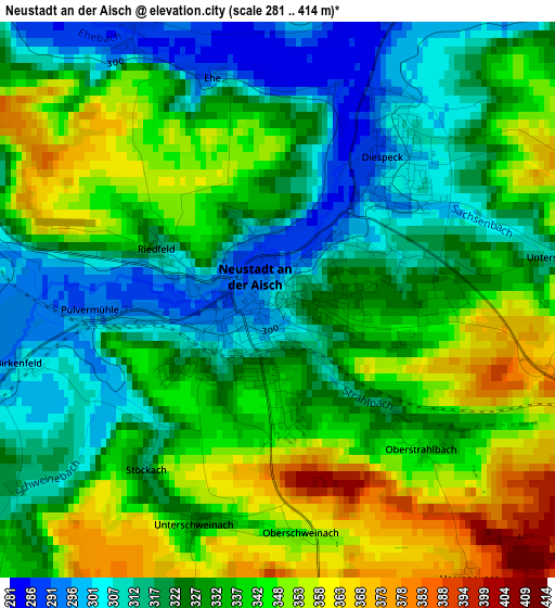
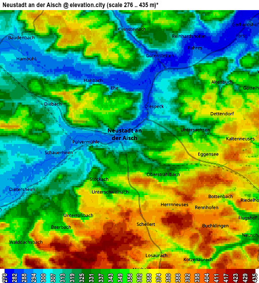
Below is the Elevation map of Neustadt an der Aisch, which displays elevation range with different colors. Scale of the first map is from 281 to 414 m (922 to 1358 ft) with average elevation of 331.9 meters (=1089 ft) [note 1]
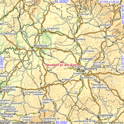
These maps also provides idea of topography and contour of this city, they are displayed at different zoom levels. More info about maps, scale and edge coordinates you can find below images.
| \ | Map #1 | Map #2 | Topo.Map |
| Scale [m] | 281..414 m | 276..435 m | × |
| Scale [ft] | 922..1358 ft | 906..1427 ft | × |
| Average | 331.9 m = 1089 ft | 344.3 m = 1130 ft | × |
| Width | 6.34 km = 3.9 mi | 12.67 km = 7.9 mi | 202.8 km = 126 mi |
| Height | 6.34 km = 3.9 mi | 12.67 km = 7.9 mi | 202.8 km = 126 mi |
| ↑Max Latitude | 49.608015° | 49.636484° | 50.48283° |
| Latitude at center | 49.57953° | 49.57953° | 49.57953° |
| ↓Min Latitude | 49.551028° | 49.522509° | 48.6592° |
| ← Min Longitude | 10.567315° | 10.523369° | 9.20501° |
| Longitude center | 10.61126° | 10.61126° | 10.61126° |
| →Max Longitude | 10.655205° | 10.699151° | 12.01751° |
Nearby cities:
Cities around Neustadt an der Aisch sort by population:
• Emskirchen elevation 352 m
7.9 km,  112°
112°
• Markt Erlbach 388 m
10 km,  162°
162°
• Diespeck 300 m
2.8 km,  34°
34°
• Gerhardshofen 289 m
8.1 km,  45°
45°
• Ipsheim 307 m
11 km,  238°
238°
• Dietersheim 301 m
5.7 km, 243°
• Münchsteinach 301 m
6.8 km,  350°
350°
• Gutenstetten 285 m
4.4 km,  21°
21°
• Wilhelmsdorf 329 m
9.2 km,  100°
100°
• Oberreichenbach 348 m
11.4 km,  84°
84°
• Baudenbach 298 m
7.4 km,  313°
313°
• Langenfeld 295 m
8 km,  301°
301°
Multilingual:
 En español:
Neustadt an der Aisch elevación 309 m.
 En France:
Neustadt an der Aisch élévation 309 m.
 Auf Deutsch:
Neustadt an der Aisch höhe über dem Meeresspiegel ist 309 m.
 На русском:
Нойштадт-ан-дер-Айш высота над уровнем моря 309 м
Sources and notes:
- [note 1] Map square and city borders are not equal. Map elevation data is calculated only from area inside that square.
- [src 1] Elevation data from geonames database provided with same terms of usage.
- [src 2] The elevation map of Neustadt an der Aisch is generated using elevation data from NASA's 3 arcsec (90m) resolution SRTM data.
- [src 3] Base (background) map © OpenStreetMap contributors tiles are generated by Geofabrik and OpenTopoMap.
Copyright & License:
This Neustadt an der Aisch Elevation Map is licensed under CC BY-SA. You may reuse any part from this page, if you give a proper credit by linking to this URL:
 More info on terms of use page.