Nordwalde elevation
Nordwalde (North Rhine-Westphalia, Regierungsbezirk Münster), Germany elevation is 48 meters and Nordwalde elevation in feet is 157 ft above sea level [src 1]. Nordwalde is a seat of a fourth-order administrative division (feature code) with elevation that is 210 meters (689 ft) smaller than average city elevation in Germany.
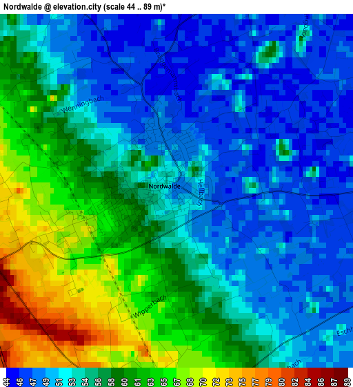
Below is the Elevation map of Nordwalde, which displays elevation range with different colors. Scale of the first map is from 44 to 89 m (144 to 292 ft) with average elevation of 55.4 meters (=182 ft) [note 1]
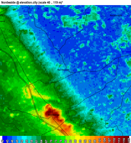
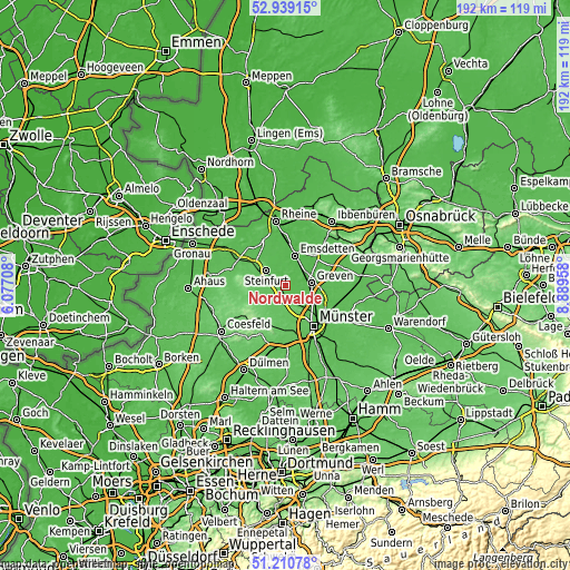
These maps also provides idea of topography and contour of this city, they are displayed at different zoom levels. More info about maps, scale and edge coordinates you can find below images.
| \ | Map #1 | Map #2 | Topo.Map |
| Scale [m] | 44..89 m | 40..119 m | × |
| Scale [ft] | 144..292 ft | 131..390 ft | × |
| Average | 55.4 m = 182 ft | 58.8 m = 193 ft | × |
| Width | 6.01 km = 3.7 mi | 12.01 km = 7.5 mi | 192.2 km = 119.4 mi |
| Height | 6.01 km = 3.7 mi | 12.01 km = 7.5 mi | 192.2 km = 119.4 mi |
| ↑Max Latitude | 52.110327° | 52.137307° | 52.93915° |
| Latitude at center | 52.08333° | 52.08333° | 52.08333° |
| ↓Min Latitude | 52.056317° | 52.029287° | 51.21078° |
| ← Min Longitude | 7.439385° | 7.395439° | 6.07708° |
| Longitude center | 7.48333° | 7.48333° | 7.48333° |
| →Max Longitude | 7.527275° | 7.571221° | 8.88958° |
Nearby cities:
Cities around Nordwalde sort by population:
• Münster elevation 64 m
16.6 km,  144°
144°
• Emsdetten 44 m
10.5 km,  16°
16°
• Greven 45 m
7.6 km,  81°
81°
• Steinfurt 59 m
12.5 km,  306°
306°
• Havixbeck 78 m
12 km,  202°
202°
• Billerbeck 116 m
17.5 km,  228°
228°
• Altenberge 108 m
3.9 km, 197°
• Schöppingen 86 m
17.2 km,  276°
276°
• Wettringen 49 m
18 km,  321°
321°
• Saerbeck 46 m
14.4 km,  45°
45°
• Horstmar 104 m
12.2 km,  268°
268°
• Laer 78 m
9.1 km,  250°
250°
Multilingual:
 En español:
Nordwalde elevación 48 m.
 En France:
Nordwalde élévation 48 m.
 Auf Deutsch:
Nordwalde höhe über dem Meeresspiegel ist 48 m.

Sources and notes:
- [note 1] Map square and city borders are not equal. Map elevation data is calculated only from area inside that square.
- [src 1] Elevation data from geonames database provided with same terms of usage.
- [src 2] The elevation map of Nordwalde is generated using elevation data from NASA's 3 arcsec (90m) resolution SRTM data.
- [src 3] Base (background) map © OpenStreetMap contributors tiles are generated by Geofabrik and OpenTopoMap.
Copyright & License:
This Nordwalde Elevation Map is licensed under CC BY-SA. You may reuse any part from this page, if you give a proper credit by linking to this URL:
 More info on terms of use page.