Obersontheim elevation
Obersontheim (Baden-Württemberg, Regierungsbezirk Stuttgart), Germany elevation is 371 meters and Obersontheim elevation in feet is 1217 ft above sea level [src 1]. Obersontheim is a seat of a fourth-order administrative division (feature code) with elevation that is 113 meters (371 ft) bigger than average city elevation in Germany.
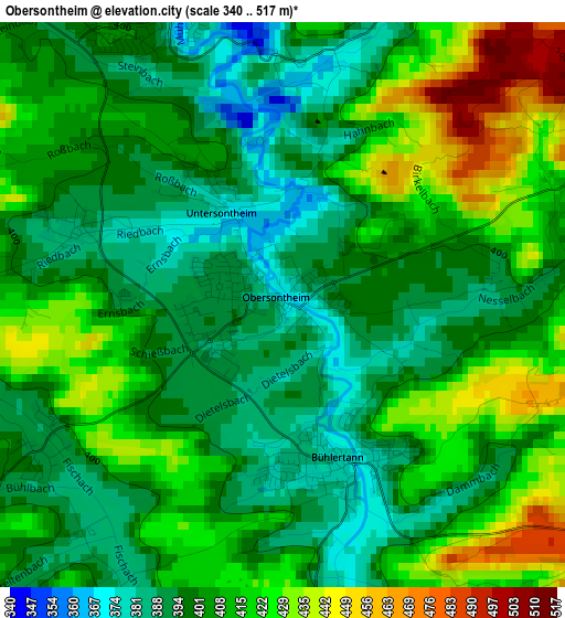
Below is the Elevation map of Obersontheim, which displays elevation range with different colors. Scale of the first map is from 340 to 517 m (1115 to 1696 ft) with average elevation of 406.4 meters (=1333 ft) [note 1]
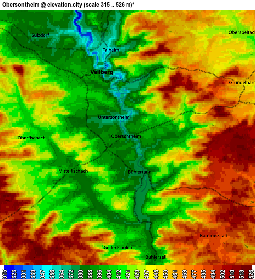
These maps also provides idea of topography and contour of this city, they are displayed at different zoom levels. More info about maps, scale and edge coordinates you can find below images.
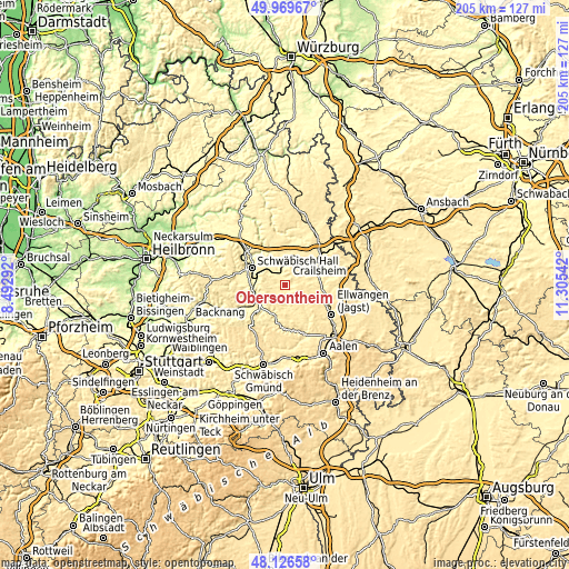
| \ | Map #1 | Map #2 | Topo.Map |
| Scale [m] | 340..517 m | 315..526 m | × |
| Scale [ft] | 1115..1696 ft | 1033..1726 ft | × |
| Average | 406.4 m = 1333 ft | 435.8 m = 1430 ft | × |
| Width | 6.4 km = 4 mi | 12.81 km = 8 mi | 204.9 km = 127.3 mi |
| Height | 6.4 km = 4 mi | 12.81 km = 8 mi | 204.9 km = 127.3 mi |
| ↑Max Latitude | 49.08546° | 49.114232° | 49.96967° |
| Latitude at center | 49.05667° | 49.05667° | 49.05667° |
| ↓Min Latitude | 49.027864° | 48.999041° | 48.12658° |
| ← Min Longitude | 9.855225° | 9.811279° | 8.49292° |
| Longitude center | 9.89917° | 9.89917° | 9.89917° |
| →Max Longitude | 9.943115° | 9.987061° | 11.30542° |
Nearby cities:
Cities around Obersontheim sort by population:
• Schwäbisch Hall elevation 322 m
13.1 km,  297°
297°
• Gaildorf 337 m
11.3 km,  236°
236°
• Ilshofen 443 m
12.7 km,  6°
6°
• Gerabronn 454 m
9.7 km,  171°
171°
• Vellberg 393 m
3.4 km,  334°
334°
• Michelbach an der Bilz 364 m
10.1 km,  278°
278°
• Stimpfach 415 m
14.1 km,  87°
87°
• Bühlertann 377 m
1.8 km,  157°
157°
• Rosenberg 498 m
10.4 km,  113°
113°
• Bühlerzell 396 m
6.1 km, 165°
• Wolpertshausen 443 m
12.9 km,  342°
342°
• Adelmannsfelden 476 m
13.7 km,  145°
145°
Multilingual:
 En español:
Obersontheim elevación 371 m.
 En France:
Obersontheim élévation 371 m.
 Auf Deutsch:
Obersontheim höhe über dem Meeresspiegel ist 371 m.

Sources and notes:
- [note 1] Map square and city borders are not equal. Map elevation data is calculated only from area inside that square.
- [src 1] Elevation data from geonames database provided with same terms of usage.
- [src 2] The elevation map of Obersontheim is generated using elevation data from NASA's 3 arcsec (90m) resolution SRTM data.
- [src 3] Base (background) map © OpenStreetMap contributors tiles are generated by Geofabrik and OpenTopoMap.
Copyright & License:
This Obersontheim Elevation Map is licensed under CC BY-SA. You may reuse any part from this page, if you give a proper credit by linking to this URL:
 More info on terms of use page.