Oberwolfach elevation
Oberwolfach (Baden-Württemberg, Freiburg Region), Germany elevation is 288 meters and Oberwolfach elevation in feet is 945 ft above sea level [src 1]. Oberwolfach is a seat of a fourth-order administrative division (feature code) with elevation that is 30 meters (98 ft) bigger than average city elevation in Germany.
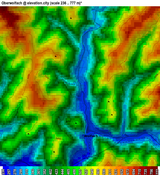
Below is the Elevation map of Oberwolfach, which displays elevation range with different colors. Scale of the first map is from 236 to 777 m (774 to 2549 ft) with average elevation of 467.4 meters (=1533 ft) [note 1]
These maps also provides idea of topography and contour of this city, they are displayed at different zoom levels. More info about maps, scale and edge coordinates you can find below images.
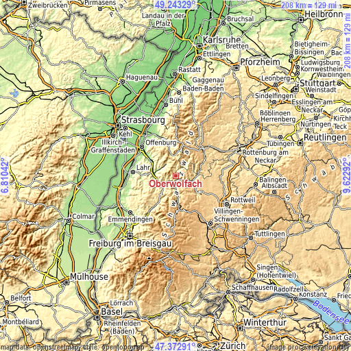
| \ | Map #1 | Topo.Map |
| Scale [m] | 236..777 m | × |
| Scale [ft] | 774..2549 ft | × |
| Average | 467.4 m = 1533 ft | × |
| Width | 6.5 km = 4 mi | 208 km = 129.2 mi |
| Height | 6.5 km = 4 mi | 208 km = 129.2 mi |
| ↑Max Latitude | 48.345886° | 49.24329° |
| Latitude at center | 48.31667° | 48.31667° |
| ↓Min Latitude | 48.287437° | 47.37291° |
| ← Min Longitude | 8.172725° | 6.81042° |
| Longitude center | 8.21667° | 8.21667° |
| →Max Longitude | 8.260615° | 9.62292° |
Nearby cities:
Cities around Oberwolfach sort by population:
• Wolfach elevation 277 m
2.6 km,  181°
181°
• Hausach 239 m
4.7 km,  219°
219°
• Hornberg 368 m
11.8 km,  174°
174°
• Schiltach 334 m
9.7 km,  108°
108°
• Steinach 278 m
12.5 km,  261°
261°
• Bad Peterstal-Griesbach 446 m
13 km,  0°
0°
• Oberharmersbach 299 m
9.2 km,  313°
313°
• Gutach 295 m
7.6 km, 182°
• Schenkenzell 361 m
11.5 km,  92°
92°
• Mühlenbach 374 m
10.5 km, 224°
• Hofstetten 274 m
12.9 km,  239°
239°
• Fischerbach 235 m
8.6 km,  247°
247°
Multilingual:
 En español:
Oberwolfach elevación 288 m.
 En France:
Oberwolfach élévation 288 m.
 Auf Deutsch:
Oberwolfach höhe über dem Meeresspiegel ist 288 m.

Sources and notes:
- [note 1] Map square and city borders are not equal. Map elevation data is calculated only from area inside that square.
- [src 1] Elevation data from geonames database provided with same terms of usage.
- [src 2] The elevation map of Oberwolfach is generated using elevation data from NASA's 3 arcsec (90m) resolution SRTM data.
- [src 3] Base (background) map © OpenStreetMap contributors tiles are generated by Geofabrik and OpenTopoMap.
Copyright & License:
This Oberwolfach Elevation Map is licensed under CC BY-SA. You may reuse any part from this page, if you give a proper credit by linking to this URL:
 More info on terms of use page.