Oettingen in Bayern elevation
Oettingen in Bayern (Bavaria, Swabia), Germany elevation is 420 meters and Oettingen in Bayern elevation in feet is 1378 ft above sea level [src 1]. Oettingen in Bayern is a populated place (feature code) with elevation that is 162 meters (531 ft) bigger than average city elevation in Germany.
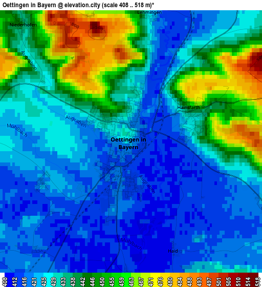
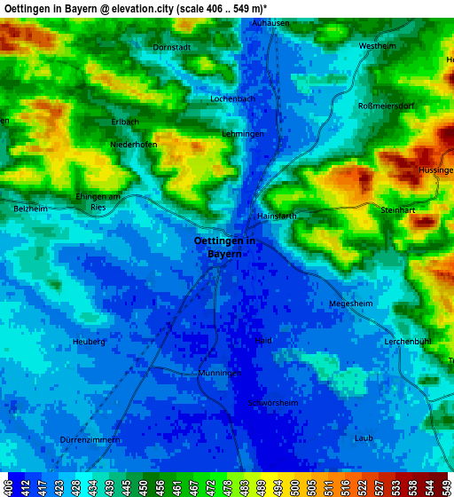
Below is the Elevation map of Oettingen in Bayern, which displays elevation range with different colors. Scale of the first map is from 408 to 518 m (1339 to 1699 ft) with average elevation of 432.4 meters (=1419 ft) [note 1]
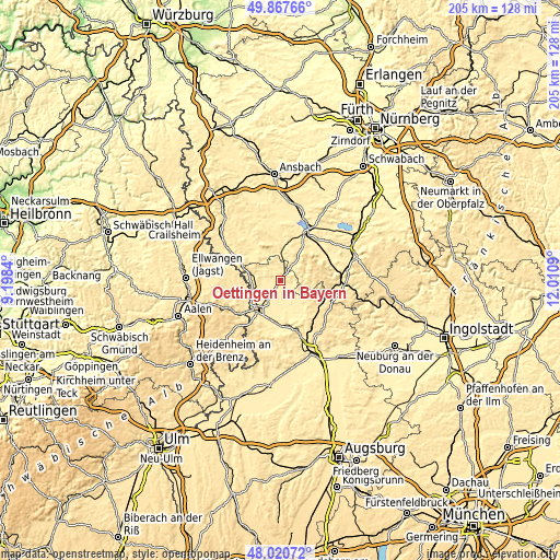
These maps also provides idea of topography and contour of this city, they are displayed at different zoom levels. More info about maps, scale and edge coordinates you can find below images.
| \ | Map #1 | Map #2 | Topo.Map |
| Scale [m] | 408..518 m | 406..549 m | × |
| Scale [ft] | 1339..1699 ft | 1332..1801 ft | × |
| Average | 432.4 m = 1419 ft | 440.6 m = 1446 ft | × |
| Width | 6.42 km = 4 mi | 12.83 km = 8 mi | 205.4 km = 127.6 mi |
| Height | 6.42 km = 4 mi | 12.83 km = 8 mi | 205.3 km = 127.6 mi |
| ↑Max Latitude | 48.98159° | 49.010423° | 49.86766° |
| Latitude at center | 48.95274° | 48.95274° | 48.95274° |
| ↓Min Latitude | 48.923874° | 48.89499° | 48.02072° |
| ← Min Longitude | 10.560705° | 10.516759° | 9.1984° |
| Longitude center | 10.60465° | 10.60465° | 10.60465° |
| →Max Longitude | 10.648595° | 10.692541° | 12.0109° |
Nearby cities:
Cities around Oettingen in Bayern sort by population:
• Wassertrüdingen elevation 427 m
10.1 km,  357°
357°
• Fremdingen 446 m
11 km,  281°
281°
• Deiningen 421 m
10 km,  196°
196°
• Polsingen 446 m
8.6 km,  114°
114°
• Munningen 417 m
4 km,  184°
184°
• Alerheim 413 m
11.5 km, 175°
• Hainsfarth 431 m
1.6 km,  66°
66°
• Wechingen 412 m
6.8 km,  174°
174°
• Marktoffingen 448 m
10.2 km,  252°
252°
• Maihingen 429 m
8.2 km, 250°
• Westheim 451 m
6.9 km,  40°
40°
• Auhausen 426 m
6.3 km,  11°
11°
Multilingual:
 En español:
Oettingen in Bayern elevación 420 m.
 En France:
Oettingen in Bayern élévation 420 m.
 Auf Deutsch:
Oettingen in Bayern höhe über dem Meeresspiegel ist 420 m.
 На русском:
Эттинген-ин-Байерн высота над уровнем моря 420 м
Sources and notes:
- [note 1] Map square and city borders are not equal. Map elevation data is calculated only from area inside that square.
- [src 1] Elevation data from geonames database provided with same terms of usage.
- [src 2] The elevation map of Oettingen in Bayern is generated using elevation data from NASA's 3 arcsec (90m) resolution SRTM data.
- [src 3] Base (background) map © OpenStreetMap contributors tiles are generated by Geofabrik and OpenTopoMap.
Copyright & License:
This Oettingen in Bayern Elevation Map is licensed under CC BY-SA. You may reuse any part from this page, if you give a proper credit by linking to this URL:
 More info on terms of use page.