Pappenheim elevation
Pappenheim (Bavaria, Regierungsbezirk Mittelfranken), Germany elevation is 412 meters and Pappenheim elevation in feet is 1352 ft above sea level [src 1]. Pappenheim is a populated place (feature code) with elevation that is 154 meters (505 ft) bigger than average city elevation in Germany.
Below is the Elevation map of Pappenheim, which displays elevation range with different colors. Scale of the first map is from 400 to 581 m (1312 to 1906 ft) with average elevation of 504.4 meters (=1655 ft) [note 1]
These maps also provides idea of topography and contour of this city, they are displayed at different zoom levels. More info about maps, scale and edge coordinates you can find below images.
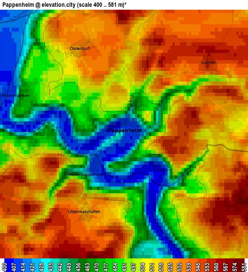
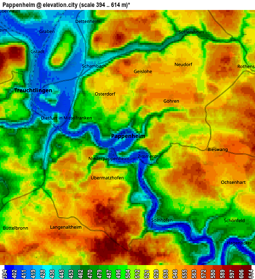
| \ | Map #1 | Map #2 | Topo.Map |
| Scale [m] | 400..581 m | 394..614 m | × |
| Scale [ft] | 1312..1906 ft | 1293..2014 ft | × |
| Average | 504.4 m = 1655 ft | 509.2 m = 1671 ft | × |
| Width | 6.42 km = 4 mi | 12.84 km = 8 mi | 205.4 km = 127.6 mi |
| Height | 6.42 km = 4 mi | 12.84 km = 8 mi | 205.4 km = 127.6 mi |
| ↑Max Latitude | 48.962691° | 48.991535° | 49.8491° |
| Latitude at center | 48.93383° | 48.93383° | 48.93383° |
| ↓Min Latitude | 48.904953° | 48.876059° | 48.00146° |
| ← Min Longitude | 10.930365° | 10.886419° | 9.56806° |
| Longitude center | 10.97431° | 10.97431° | 10.97431° |
| →Max Longitude | 11.018255° | 11.062201° | 12.38056° |
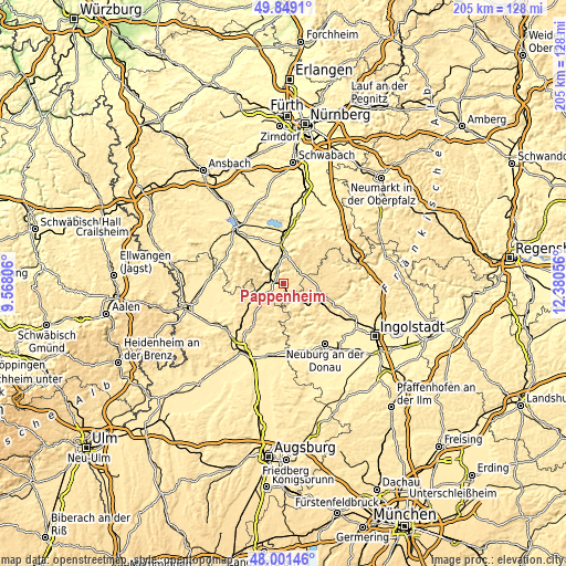
Nearby cities:
Cities around Pappenheim sort by population:
• Weißenburg in Bayern elevation 428 m
10.8 km,  359°
359°
• Treuchtlingen 420 m
5.3 km,  295°
295°
• Monheim 497 m
13.1 km,  220°
220°
• Ellingen 397 m
14.1 km, 358°
• Langenaltheim 555 m
5.5 km,  214°
214°
• Solnhofen 449 m
4.5 km,  159°
159°
• Markt Berolzheim 422 m
12.7 km,  311°
311°
• Höttingen 427 m
14.5 km,  8°
8°
• Burgsalach 584 m
14.2 km,  39°
39°
• Raitenbuch 561 m
14.2 km,  50°
50°
• Wolferstadt 491 m
14.5 km,  256°
256°
• Tagmersheim 499 m
13 km,  182°
182°
Multilingual:
 En español:
Pappenheim elevación 412 m.
 En France:
Pappenheim élévation 412 m.
 Auf Deutsch:
Pappenheim höhe über dem Meeresspiegel ist 412 m.

Sources and notes:
- [note 1] Map square and city borders are not equal. Map elevation data is calculated only from area inside that square.
- [src 1] Elevation data from geonames database provided with same terms of usage.
- [src 2] The elevation map of Pappenheim is generated using elevation data from NASA's 3 arcsec (90m) resolution SRTM data.
- [src 3] Base (background) map © OpenStreetMap contributors tiles are generated by Geofabrik and OpenTopoMap.
Copyright & License:
This Pappenheim Elevation Map is licensed under CC BY-SA. You may reuse any part from this page, if you give a proper credit by linking to this URL:
 More info on terms of use page.