Penkun elevation
Penkun (Mecklenburg-Vorpommern), Germany elevation is 38 meters and Penkun elevation in feet is 125 ft above sea level [src 1]. Penkun is a populated place (feature code) with elevation that is 220 meters (722 ft) smaller than average city elevation in Germany.
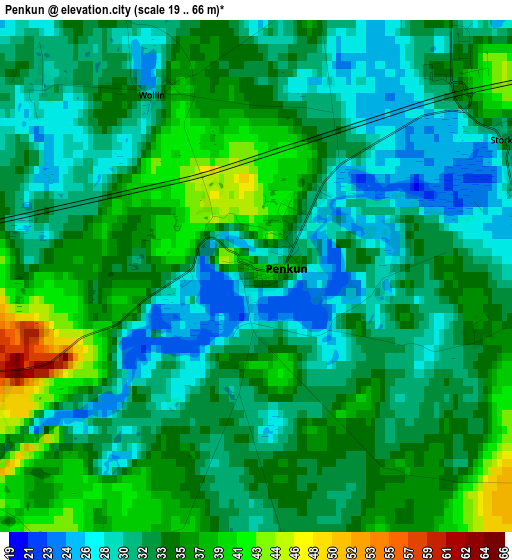
Below is the Elevation map of Penkun, which displays elevation range with different colors. Scale of the first map is from 19 to 66 m (62 to 217 ft) with average elevation of 33.5 meters (=110 ft) [note 1]
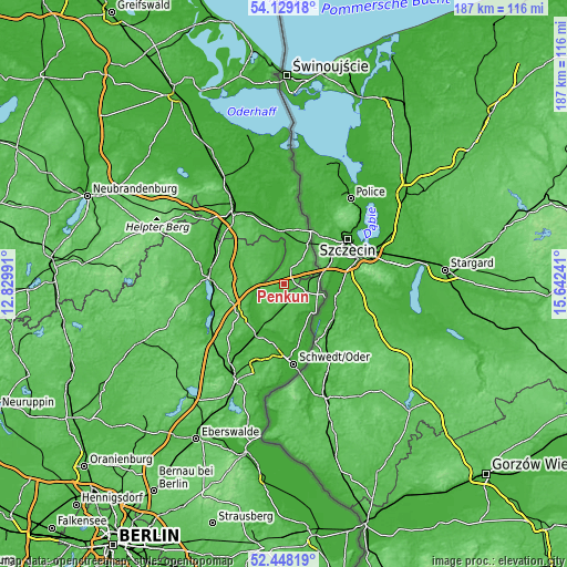
These maps also provides idea of topography and contour of this city, they are displayed at different zoom levels. More info about maps, scale and edge coordinates you can find below images.
| \ | Map #1 | Topo.Map |
| Scale [m] | 19..66 m | × |
| Scale [ft] | 62..217 ft | × |
| Average | 33.5 m = 110 ft | × |
| Width | 5.84 km = 3.6 mi | 186.9 km = 116.1 mi |
| Height | 5.84 km = 3.6 mi | 186.9 km = 116.1 mi |
| ↑Max Latitude | 53.323207° | 54.12918° |
| Latitude at center | 53.29695° | 53.29695° |
| ↓Min Latitude | 53.270677° | 52.44819° |
| ← Min Longitude | 14.192215° | 12.82991° |
| Longitude center | 14.23616° | 14.23616° |
| →Max Longitude | 14.280105° | 15.64241° |
Nearby cities:
Cities around Penkun sort by population:
• Schwedt (Oder) elevation 2 m
26.6 km,  173°
173°
• Prenzlau 32 m
24.9 km,  274°
274°
• Angermünde 47 m
35.1 km,  206°
206°
• Pasewalk 16 m
28.4 km,  324°
324°
• Gartz 11 m
14.3 km,  133°
133°
• Meyenburg 11 m
28 km,  179°
179°
• Casekow 22 m
9.7 km,  191°
191°
• Brüssow 57 m
13.6 km,  327°
327°
• Gramzow 63 m
17.9 km,  238°
238°
• Jatznick 21 m
37.1 km, 327°
• Gerswalde 51 m
35.4 km,  246°
246°
• Viereck 8 m
30.9 km,  335°
335°
Multilingual:
 En español:
Penkun elevación 38 m.
 En France:
Penkun élévation 38 m.


Sources and notes:
- [note 1] Map square and city borders are not equal. Map elevation data is calculated only from area inside that square.
- [src 1] Elevation data from geonames database provided with same terms of usage.
- [src 2] The elevation map of Penkun is generated using elevation data from NASA's 3 arcsec (90m) resolution SRTM data.
- [src 3] Base (background) map © OpenStreetMap contributors tiles are generated by Geofabrik and OpenTopoMap.
Copyright & License:
This Penkun Elevation Map is licensed under CC BY-SA. You may reuse any part from this page, if you give a proper credit by linking to this URL:
 More info on terms of use page.