Raschau elevation
Raschau (Saxony), Germany elevation is 453 meters and Raschau elevation in feet is 1486 ft above sea level [src 1]. Raschau is a populated place (feature code) with elevation that is 195 meters (640 ft) bigger than average city elevation in Germany.
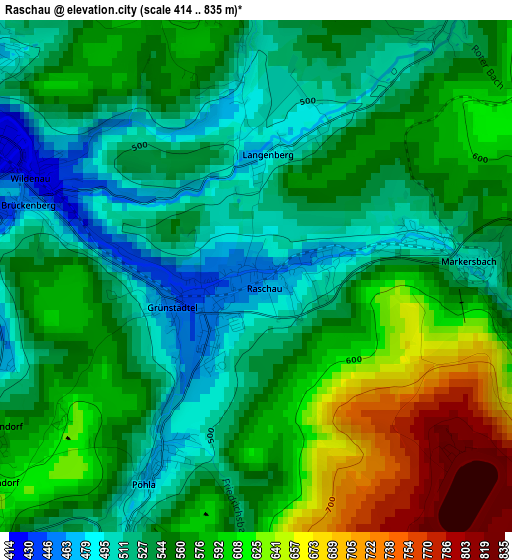
Below is the Elevation map of Raschau, which displays elevation range with different colors. Scale of the first map is from 414 to 835 m (1358 to 2740 ft) with average elevation of 560.6 meters (=1839 ft) [note 1]
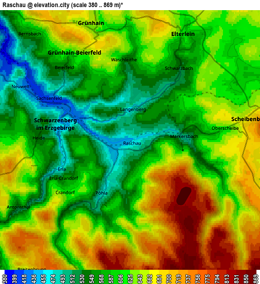
These maps also provides idea of topography and contour of this city, they are displayed at different zoom levels. More info about maps, scale and edge coordinates you can find below images.
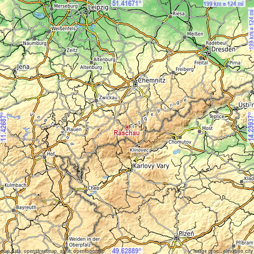
| \ | Map #1 | Map #2 | Topo.Map |
| Scale [m] | 414..835 m | 380..869 m | × |
| Scale [ft] | 1358..2740 ft | 1247..2851 ft | × |
| Average | 560.6 m = 1839 ft | 620 m = 2034 ft | × |
| Width | 6.21 km = 3.9 mi | 12.42 km = 7.7 mi | 198.8 km = 123.5 mi |
| Height | 6.21 km = 3.9 mi | 12.42 km = 7.7 mi | 198.8 km = 123.5 mi |
| ↑Max Latitude | 50.559196° | 50.587105° | 51.41671° |
| Latitude at center | 50.53127° | 50.53127° | 50.53127° |
| ↓Min Latitude | 50.503328° | 50.475369° | 49.62889° |
| ← Min Longitude | 12.789175° | 12.745229° | 11.42687° |
| Longitude center | 12.83312° | 12.83312° | 12.83312° |
| →Max Longitude | 12.877065° | 12.921011° | 14.23937° |
Nearby cities:
Cities around Raschau sort by population:
• Schwarzenberg elevation 467 m
3.5 km,  282°
282°
• Lauter 465 m
7.8 km,  296°
296°
• Crottendorf 643 m
8.4 km,  101°
101°
• Bernsbach 557 m
6.8 km,  317°
317°
• Beierfeld 570 m
4.8 km, 321°
• Breitenbrunn 695 m
7.8 km,  217°
217°
• Elterlein 608 m
5.6 km,  26°
26°
• Grünhain 632 m
5.7 km,  341°
341°
• Scheibenberg 683 m
5.7 km,  79°
79°
• Markersbach 486 m
2.1 km, 76°
• Rittersgrün 593 m
6.3 km,  206°
206°
• Pöhla 481 m
2.4 km,  204°
204°
Multilingual:
 En español:
Raschau elevación 453 m.
 En France:
Raschau élévation 453 m.


Sources and notes:
- [note 1] Map square and city borders are not equal. Map elevation data is calculated only from area inside that square.
- [src 1] Elevation data from geonames database provided with same terms of usage.
- [src 2] The elevation map of Raschau is generated using elevation data from NASA's 3 arcsec (90m) resolution SRTM data.
- [src 3] Base (background) map © OpenStreetMap contributors tiles are generated by Geofabrik and OpenTopoMap.
Copyright & License:
This Raschau Elevation Map is licensed under CC BY-SA. You may reuse any part from this page, if you give a proper credit by linking to this URL:
 More info on terms of use page.