Rheinzabern elevation
Rheinzabern (Rheinland-Pfalz), Germany elevation is 113 meters and Rheinzabern elevation in feet is 371 ft above sea level [src 1]. Rheinzabern is a seat of a fourth-order administrative division (feature code) with elevation that is 145 meters (476 ft) smaller than average city elevation in Germany.
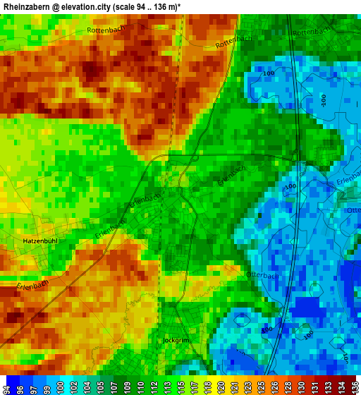
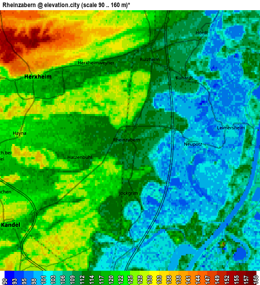
Below is the Elevation map of Rheinzabern, which displays elevation range with different colors. Scale of the first map is from 94 to 136 m (308 to 446 ft) with average elevation of 113.7 meters (=373 ft) [note 1]
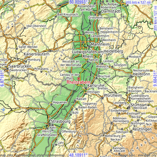
These maps also provides idea of topography and contour of this city, they are displayed at different zoom levels. More info about maps, scale and edge coordinates you can find below images.
| \ | Map #1 | Map #2 | Topo.Map |
| Scale [m] | 94..136 m | 90..160 m | × |
| Scale [ft] | 308..446 ft | 295..525 ft | × |
| Average | 113.7 m = 373 ft | 115.2 m = 378 ft | × |
| Width | 6.4 km = 4 mi | 12.79 km = 7.9 mi | 204.7 km = 127.2 mi |
| Height | 6.4 km = 4 mi | 12.79 km = 7.9 mi | 204.7 km = 127.2 mi |
| ↑Max Latitude | 49.146814° | 49.175551° | 50.02993° |
| Latitude at center | 49.11806° | 49.11806° | 49.11806° |
| ↓Min Latitude | 49.089289° | 49.060502° | 48.18911° |
| ← Min Longitude | 8.234115° | 8.190169° | 6.87181° |
| Longitude center | 8.27806° | 8.27806° | 8.27806° |
| →Max Longitude | 8.322005° | 8.365951° | 9.68431° |
Nearby cities:
Cities around Rheinzabern sort by population:
• Wörth am Rhein elevation 116 m
7.8 km,  189°
189°
• Bellheim 117 m
8.9 km,  0°
0°
• Kandel 126 m
7.1 km,  236°
236°
• Rülzheim 109 m
4 km,  15°
15°
• Jockgrim 114 m
2.8 km, 185°
• Hatzenbühl 117 m
2.5 km,  252°
252°
• Leimersheim 103 m
4.9 km,  82°
82°
• Hördt 111 m
6.4 km,  33°
33°
• Kuhardt 111 m
4.1 km,  40°
40°
• Ottersheim 126 m
8.8 km,  337°
337°
• Neupotz 104 m
3 km,  90°
90°
• Knittelsheim 126 m
8.4 km,  346°
346°
Multilingual:
 En español:
Rheinzabern elevación 113 m.
 En France:
Rheinzabern élévation 113 m.
 Auf Deutsch:
Rheinzabern höhe über dem Meeresspiegel ist 113 m.

Sources and notes:
- [note 1] Map square and city borders are not equal. Map elevation data is calculated only from area inside that square.
- [src 1] Elevation data from geonames database provided with same terms of usage.
- [src 2] The elevation map of Rheinzabern is generated using elevation data from NASA's 3 arcsec (90m) resolution SRTM data.
- [src 3] Base (background) map © OpenStreetMap contributors tiles are generated by Geofabrik and OpenTopoMap.
Copyright & License:
This Rheinzabern Elevation Map is licensed under CC BY-SA. You may reuse any part from this page, if you give a proper credit by linking to this URL:
 More info on terms of use page.