Rietberg elevation
Rietberg (North Rhine-Westphalia, Regierungsbezirk Detmold), Germany elevation is 80 meters and Rietberg elevation in feet is 262 ft above sea level [src 1]. Rietberg is a populated place (feature code) with elevation that is 178 meters (584 ft) smaller than average city elevation in Germany.
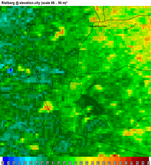
Below is the Elevation map of Rietberg, which displays elevation range with different colors. Scale of the first map is from 68 to 90 m (223 to 295 ft) with average elevation of 77.9 meters (=256 ft) [note 1]
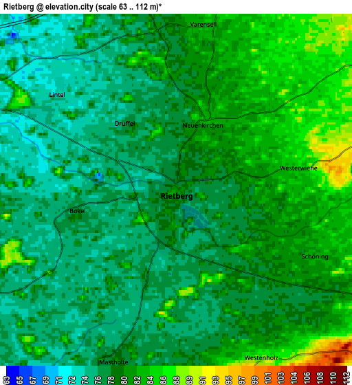
These maps also provides idea of topography and contour of this city, they are displayed at different zoom levels. More info about maps, scale and edge coordinates you can find below images.
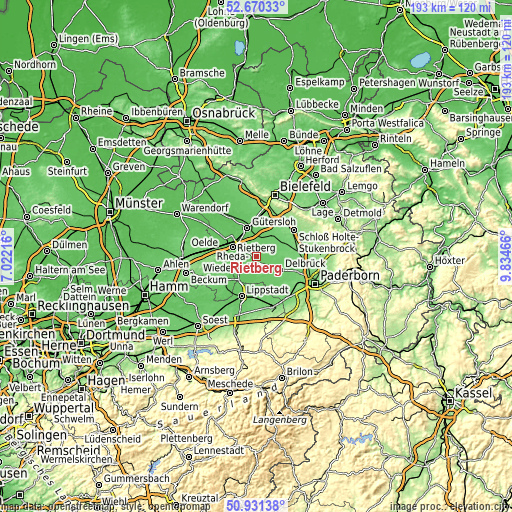
| \ | Map #1 | Map #2 | Topo.Map |
| Scale [m] | 68..90 m | 63..112 m | × |
| Scale [ft] | 223..295 ft | 207..367 ft | × |
| Average | 77.9 m = 256 ft | 79.2 m = 260 ft | × |
| Width | 6.04 km = 3.8 mi | 12.08 km = 7.5 mi | 193.4 km = 120.2 mi |
| Height | 6.04 km = 3.8 mi | 12.08 km = 7.5 mi | 193.3 km = 120.1 mi |
| ↑Max Latitude | 51.836402° | 51.863548° | 52.67033° |
| Latitude at center | 51.80924° | 51.80924° | 51.80924° |
| ↓Min Latitude | 51.782061° | 51.754866° | 50.93138° |
| ← Min Longitude | 8.384465° | 8.340519° | 7.02216° |
| Longitude center | 8.42841° | 8.42841° | 8.42841° |
| →Max Longitude | 8.472355° | 8.516301° | 9.83466° |
Nearby cities:
Cities around Rietberg sort by population:
• Gütersloh elevation 79 m
11.4 km,  342°
342°
• Lippstadt 81 m
16.1 km,  200°
200°
• Rheda-Wiedenbrück 72 m
9.9 km,  297°
297°
• Delbrück 102 m
10.4 km,  118°
118°
• Oelde 90 m
19.4 km,  276°
276°
• Salzkotten 99 m
19.4 km,  142°
142°
• Verl 94 m
10.2 km,  36°
36°
• Geseke 103 m
19.6 km,  163°
163°
• Steinhagen 96 m
21.3 km,  354°
354°
• Hövelhof 101 m
15.3 km,  86°
86°
• Wadersloh 95 m
14.9 km,  235°
235°
• Langenberg 86 m
8.6 km, 241°
Multilingual:
 En español:
Rietberg elevación 80 m.
 En France:
Rietberg élévation 80 m.


Sources and notes:
- [note 1] Map square and city borders are not equal. Map elevation data is calculated only from area inside that square.
- [src 1] Elevation data from geonames database provided with same terms of usage.
- [src 2] The elevation map of Rietberg is generated using elevation data from NASA's 3 arcsec (90m) resolution SRTM data.
- [src 3] Base (background) map © OpenStreetMap contributors tiles are generated by Geofabrik and OpenTopoMap.
Copyright & License:
This Rietberg Elevation Map is licensed under CC BY-SA. You may reuse any part from this page, if you give a proper credit by linking to this URL:
 More info on terms of use page.