Rodleben elevation
Rodleben (Saxony-Anhalt), Germany elevation is 73 meters and Rodleben elevation in feet is 240 ft above sea level [src 1]. Rodleben is a populated place (feature code) with elevation that is 185 meters (607 ft) smaller than average city elevation in Germany.
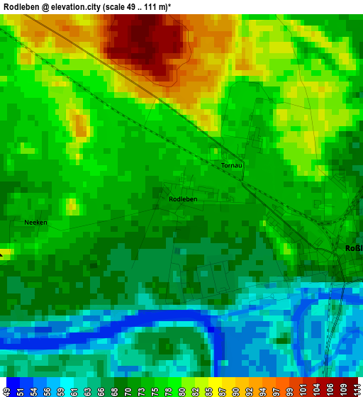
Below is the Elevation map of Rodleben, which displays elevation range with different colors. Scale of the first map is from 49 to 111 m (161 to 364 ft) with average elevation of 73.8 meters (=242 ft) [note 1]
These maps also provides idea of topography and contour of this city, they are displayed at different zoom levels. More info about maps, scale and edge coordinates you can find below images.
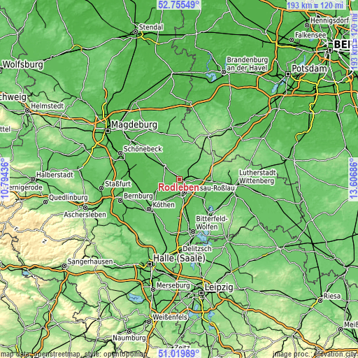
| \ | Map #1 | Topo.Map |
| Scale [m] | 49..111 m | × |
| Scale [ft] | 161..364 ft | × |
| Average | 73.8 m = 242 ft | × |
| Width | 6.03 km = 3.7 mi | 193 km = 119.9 mi |
| Height | 6.03 km = 3.7 mi | 193 km = 119.9 mi |
| ↑Max Latitude | 51.92318° | 52.75549° |
| Latitude at center | 51.89607° | 51.89607° |
| ↓Min Latitude | 51.868944° | 51.01989° |
| ← Min Longitude | 12.156665° | 10.79436° |
| Longitude center | 12.20061° | 12.20061° |
| →Max Longitude | 12.244555° | 13.60686° |
Nearby cities:
Cities around Rodleben sort by population:
• Dessau elevation 63 m
7.1 km,  154°
154°
• Zerbst 67 m
11.1 km,  314°
314°
• Roßlau 71 m
3 km,  108°
108°
• Aken 55 m
11.7 km,  245°
245°
• Osternienburger Land 64 m
16.5 km,  229°
229°
• Coswig 78 m
17.2 km,  93°
93°
• Osternienburg 72 m
16.5 km, 226°
• Vockerode 61 m
11.7 km,  117°
117°
• Wörlitz 63 m
16.3 km, 111°
• Lindau 80 m
17 km,  338°
338°
• Klieken 68 m
11.7 km, 94°
• Quellendorf 80 m
17.1 km,  196°
196°
Multilingual:
 En español:
Rodleben elevación 73 m.
 En France:
Rodleben élévation 73 m.


Sources and notes:
- [note 1] Map square and city borders are not equal. Map elevation data is calculated only from area inside that square.
- [src 1] Elevation data from geonames database provided with same terms of usage.
- [src 2] The elevation map of Rodleben is generated using elevation data from NASA's 3 arcsec (90m) resolution SRTM data.
- [src 3] Base (background) map © OpenStreetMap contributors tiles are generated by Geofabrik and OpenTopoMap.
Copyright & License:
This Rodleben Elevation Map is licensed under CC BY-SA. You may reuse any part from this page, if you give a proper credit by linking to this URL:
 More info on terms of use page.