Roigheim elevation
Roigheim (Baden-Württemberg, Regierungsbezirk Stuttgart), Germany elevation is 216 meters and Roigheim elevation in feet is 709 ft above sea level [src 1]. Roigheim is a seat of a fourth-order administrative division (feature code) with elevation that is 42 meters (138 ft) smaller than average city elevation in Germany.
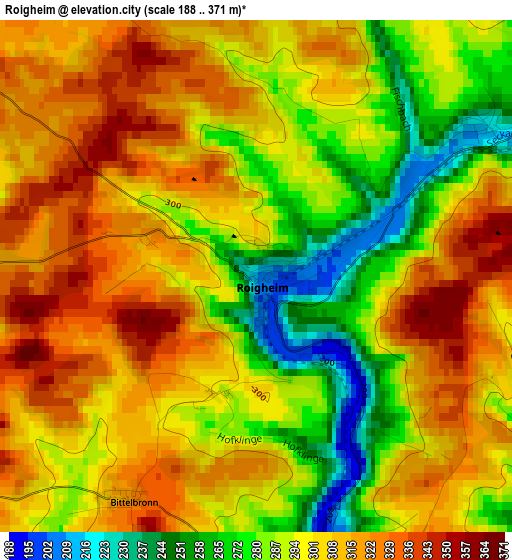
Below is the Elevation map of Roigheim, which displays elevation range with different colors. Scale of the first map is from 188 to 371 m (617 to 1217 ft) with average elevation of 299.3 meters (=982 ft) [note 1]
These maps also provides idea of topography and contour of this city, they are displayed at different zoom levels. More info about maps, scale and edge coordinates you can find below images.
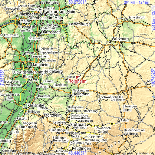
| \ | Map #1 | Topo.Map |
| Scale [m] | 188..371 m | × |
| Scale [ft] | 617..1217 ft | × |
| Average | 299.3 m = 982 ft | × |
| Width | 6.36 km = 4 mi | 203.7 km = 126.6 mi |
| Height | 6.36 km = 4 mi | 203.6 km = 126.5 mi |
| ↑Max Latitude | 49.393331° | 50.27201° |
| Latitude at center | 49.36472° | 49.36472° |
| ↓Min Latitude | 49.336093° | 48.44037° |
| ← Min Longitude | 9.296055° | 7.93375° |
| Longitude center | 9.34° | 9.34° |
| →Max Longitude | 9.383945° | 10.74625° |
Nearby cities:
Cities around Roigheim sort by population:
• Mosbach elevation 186 m
13.7 km,  264°
264°
• Neuenstadt am Kocher 178 m
14.4 km,  182°
182°
• Möckmühl 180 m
4.6 km,  163°
163°
• Osterburken 250 m
9.4 km,  39°
39°
• Oedheim 160 m
15.2 km,  204°
204°
• Billigheim 251 m
6.5 km,  253°
253°
• Adelsheim 232 m
5.6 km, 42°
• Neudenau 182 m
9.6 km,  212°
212°
• Haßmersheim 151 m
15.5 km,  242°
242°
• Seckach 269 m
8.6 km,  357°
357°
• Widdern 198 m
7.9 km,  130°
130°
• Jagsthausen 218 m
11.1 km,  122°
122°
Multilingual:
 En español:
Roigheim elevación 216 m.
 En France:
Roigheim élévation 216 m.
 Auf Deutsch:
Roigheim höhe über dem Meeresspiegel ist 216 m.

Sources and notes:
- [note 1] Map square and city borders are not equal. Map elevation data is calculated only from area inside that square.
- [src 1] Elevation data from geonames database provided with same terms of usage.
- [src 2] The elevation map of Roigheim is generated using elevation data from NASA's 3 arcsec (90m) resolution SRTM data.
- [src 3] Base (background) map © OpenStreetMap contributors tiles are generated by Geofabrik and OpenTopoMap.
Copyright & License:
This Roigheim Elevation Map is licensed under CC BY-SA. You may reuse any part from this page, if you give a proper credit by linking to this URL:
 More info on terms of use page.