Roßwein elevation
Roßwein (Saxony), Germany elevation is 208 meters and Roßwein elevation in feet is 682 ft above sea level [src 1]. Roßwein is a populated place (feature code) with elevation that is 50 meters (164 ft) smaller than average city elevation in Germany.
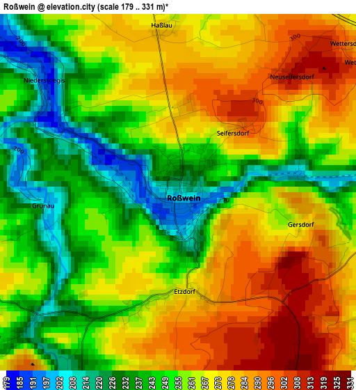
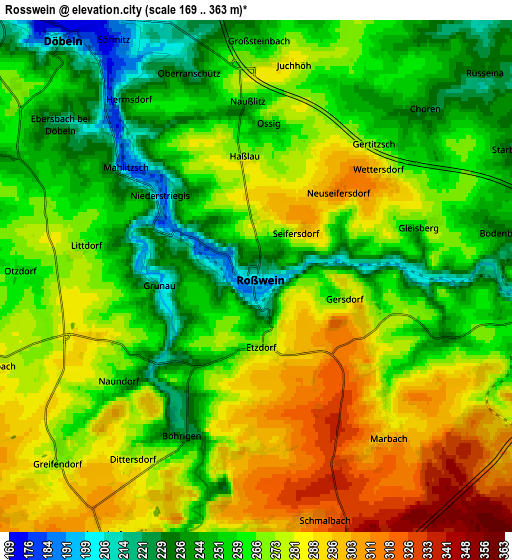
Below is the Elevation map of Roßwein, which displays elevation range with different colors. Scale of the first map is from 179 to 331 m (587 to 1086 ft) with average elevation of 261.4 meters (=858 ft) [note 1]
These maps also provides idea of topography and contour of this city, they are displayed at different zoom levels. More info about maps, scale and edge coordinates you can find below images.
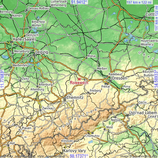
| \ | Map #1 | Map #2 | Topo.Map |
| Scale [m] | 179..331 m | 169..363 m | × |
| Scale [ft] | 587..1086 ft | 554..1191 ft | × |
| Average | 261.4 m = 858 ft | 267.4 m = 877 ft | × |
| Width | 6.14 km = 3.8 mi | 12.28 km = 7.6 mi | 196.5 km = 122.1 mi |
| Height | 6.14 km = 3.8 mi | 12.28 km = 7.6 mi | 196.5 km = 122.1 mi |
| ↑Max Latitude | 51.093498° | 51.12109° | 51.9412° |
| Latitude at center | 51.06589° | 51.06589° | 51.06589° |
| ↓Min Latitude | 51.038265° | 51.010624° | 50.17371° |
| ← Min Longitude | 13.139135° | 13.095189° | 11.77683° |
| Longitude center | 13.18308° | 13.18308° | 13.18308° |
| →Max Longitude | 13.227025° | 13.270971° | 14.58933° |
Nearby cities:
Cities around Roßwein sort by population:
• Döbeln elevation 168 m
8.1 km,  320°
320°
• Hainichen 311 m
11.4 km,  201°
201°
• Waldheim 191 m
11.4 km,  273°
273°
• Nossen 255 m
8 km,  96°
96°
• Großschirma 369 m
13.2 km,  147°
147°
• Rossau 309 m
11 km,  228°
228°
• Großweitzschen 256 m
14.1 km, 316°
• Reinsberg 278 m
14.3 km,  116°
116°
• Mochau 212 m
7.5 km,  0°
0°
• Kriebstein 194 m
11.8 km,  261°
261°
• Niederstriegis 190 m
3 km,  307°
307°
• Ebersbach 219 m
6.1 km, 307°
Multilingual:
 En español:
Roßwein elevación 208 m.
 En France:
Roßwein élévation 208 m.


Sources and notes:
- [note 1] Map square and city borders are not equal. Map elevation data is calculated only from area inside that square.
- [src 1] Elevation data from geonames database provided with same terms of usage.
- [src 2] The elevation map of Roßwein is generated using elevation data from NASA's 3 arcsec (90m) resolution SRTM data.
- [src 3] Base (background) map © OpenStreetMap contributors tiles are generated by Geofabrik and OpenTopoMap.
Copyright & License:
This Roßwein Elevation Map is licensed under CC BY-SA. You may reuse any part from this page, if you give a proper credit by linking to this URL:
 More info on terms of use page.