Rötz elevation
Rötz (Bavaria, Upper Palatinate), Germany elevation is 461 meters and Rötz elevation in feet is 1512 ft above sea level [src 1]. Rötz is a populated place (feature code) with elevation that is 203 meters (666 ft) bigger than average city elevation in Germany.
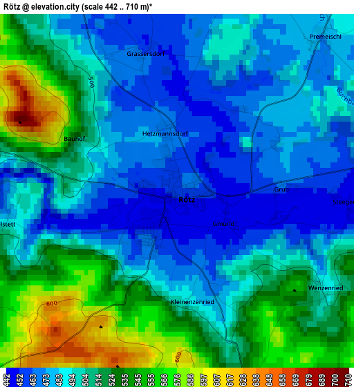
Below is the Elevation map of Rötz, which displays elevation range with different colors. Scale of the first map is from 442 to 710 m (1450 to 2329 ft) with average elevation of 502.6 meters (=1649 ft) [note 1]
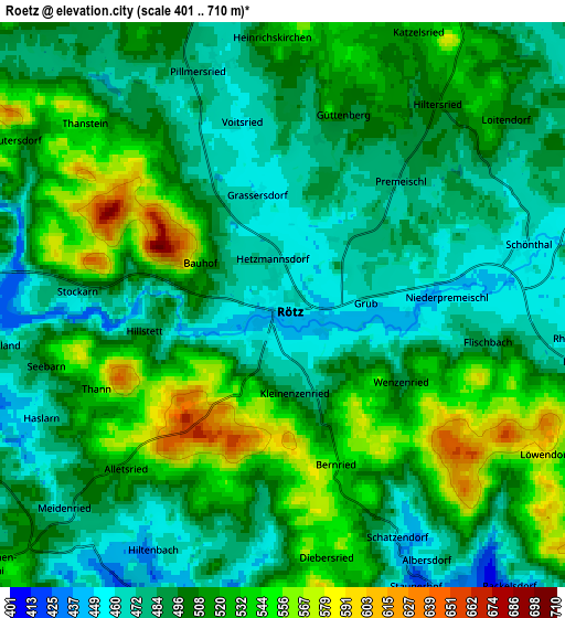
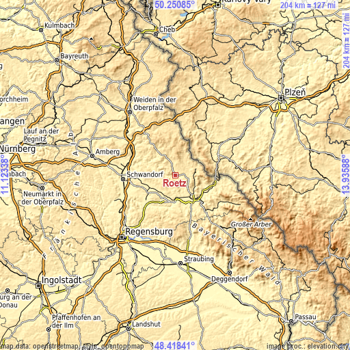
These maps also provides idea of topography and contour of this city, they are displayed at different zoom levels. More info about maps, scale and edge coordinates you can find below images.
| \ | Map #1 | Map #2 | Topo.Map |
| Scale [m] | 442..710 m | 401..710 m | × |
| Scale [ft] | 1450..2329 ft | 1316..2329 ft | × |
| Average | 502.6 m = 1649 ft | 504.1 m = 1654 ft | × |
| Width | 6.37 km = 4 mi | 12.73 km = 7.9 mi | 203.7 km = 126.6 mi |
| Height | 6.37 km = 4 mi | 12.73 km = 7.9 mi | 203.7 km = 126.6 mi |
| ↑Max Latitude | 49.371783° | 49.40039° | 50.25085° |
| Latitude at center | 49.34316° | 49.34316° | 49.34316° |
| ↓Min Latitude | 49.31452° | 49.285864° | 48.41841° |
| ← Min Longitude | 12.485685° | 12.441739° | 11.12338° |
| Longitude center | 12.52963° | 12.52963° | 12.52963° |
| →Max Longitude | 12.573575° | 12.617521° | 13.93588° |
Nearby cities:
Cities around Rötz sort by population:
• Neunburg vorm Wald elevation 390 m
10.4 km,  272°
272°
• Pettendorf 390 m
12.4 km,  275°
275°
• Stamsried 454 m
8.4 km,  179°
179°
• Pemfling 430 m
10.6 km,  143°
143°
• Schönthal 450 m
5.2 km,  81°
81°
• Waffenbrunn 421 m
13.1 km,  130°
130°
• Bach 479 m
12.3 km,  300°
300°
• Winklarn 523 m
10 km,  338°
338°
• Neukirchen-Balbini 507 m
8.9 km,  229°
229°
• Dieterskirchen 500 m
11.6 km,  314°
314°
• Thanstein 577 m
6.4 km, 314°
• Treffelstein 527 m
10.8 km,  35°
35°
Multilingual:
 En español:
Rötz elevación 461 m.
 En France:
Rötz élévation 461 m.


Sources and notes:
- [note 1] Map square and city borders are not equal. Map elevation data is calculated only from area inside that square.
- [src 1] Elevation data from geonames database provided with same terms of usage.
- [src 2] The elevation map of Rötz is generated using elevation data from NASA's 3 arcsec (90m) resolution SRTM data.
- [src 3] Base (background) map © OpenStreetMap contributors tiles are generated by Geofabrik and OpenTopoMap.
Copyright & License:
This Rötz Elevation Map is licensed under CC BY-SA. You may reuse any part from this page, if you give a proper credit by linking to this URL:
 More info on terms of use page.