Runkel elevation
Runkel (Hesse, Regierungsbezirk Gießen), Germany elevation is 126 meters and Runkel elevation in feet is 413 ft above sea level [src 1]. Runkel is a populated place (feature code) with elevation that is 132 meters (433 ft) smaller than average city elevation in Germany.
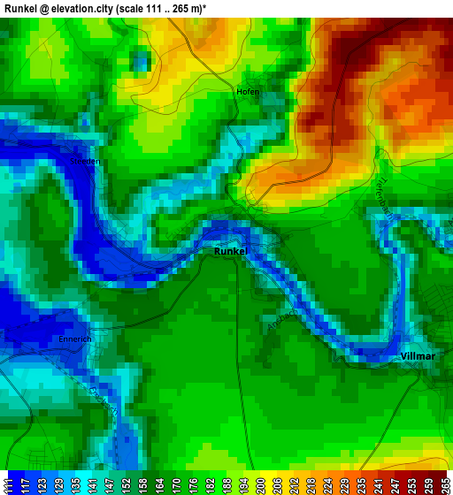
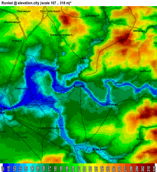
Below is the Elevation map of Runkel, which displays elevation range with different colors. Scale of the first map is from 111 to 265 m (364 to 869 ft) with average elevation of 171.8 meters (=564 ft) [note 1]
These maps also provides idea of topography and contour of this city, they are displayed at different zoom levels. More info about maps, scale and edge coordinates you can find below images.
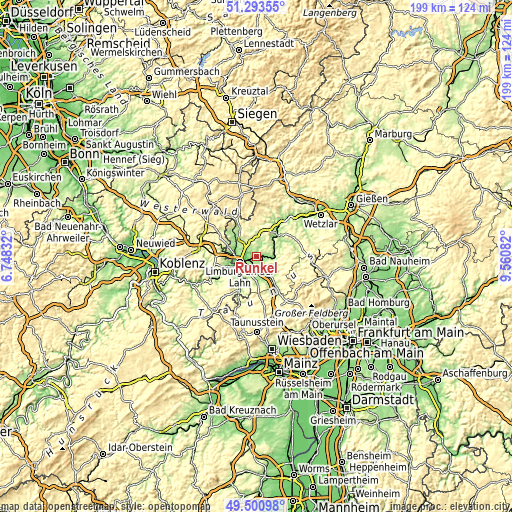
| \ | Map #1 | Map #2 | Topo.Map |
| Scale [m] | 111..265 m | 107..318 m | × |
| Scale [ft] | 364..869 ft | 351..1043 ft | × |
| Average | 171.8 m = 564 ft | 193.8 m = 636 ft | × |
| Width | 6.23 km = 3.9 mi | 12.46 km = 7.7 mi | 199.3 km = 123.8 mi |
| Height | 6.23 km = 3.9 mi | 12.46 km = 7.7 mi | 199.3 km = 123.8 mi |
| ↑Max Latitude | 50.43374° | 50.461724° | 51.29355° |
| Latitude at center | 50.40574° | 50.40574° | 50.40574° |
| ↓Min Latitude | 50.377723° | 50.34969° | 49.50098° |
| ← Min Longitude | 8.110625° | 8.066679° | 6.74832° |
| Longitude center | 8.15457° | 8.15457° | 8.15457° |
| →Max Longitude | 8.198515° | 8.242461° | 9.56082° |
Nearby cities:
Cities around Runkel sort by population:
• Limburg an der Lahn elevation 138 m
7.8 km,  251°
251°
• Hadamar 134 m
9.1 km,  299°
299°
• Diez 129 m
11 km, 251°
• Elz 159 m
8.7 km,  278°
278°
• Villmar 148 m
3.1 km,  117°
117°
• Weinbach 178 m
10.3 km,  69°
69°
• Merenberg 312 m
11.6 km,  13°
13°
• Dehrn 131 m
4.3 km,  292°
292°
• Steeden 117 m
2.2 km, 299°
• Niederneisen 157 m
10.9 km,  222°
222°
• Flacht 124 m
10 km,  227°
227°
• Gückingen 185 m
10.6 km,  261°
261°
Multilingual:
 En español:
Runkel elevación 126 m.
 En France:
Runkel élévation 126 m.


Sources and notes:
- [note 1] Map square and city borders are not equal. Map elevation data is calculated only from area inside that square.
- [src 1] Elevation data from geonames database provided with same terms of usage.
- [src 2] The elevation map of Runkel is generated using elevation data from NASA's 3 arcsec (90m) resolution SRTM data.
- [src 3] Base (background) map © OpenStreetMap contributors tiles are generated by Geofabrik and OpenTopoMap.
Copyright & License:
This Runkel Elevation Map is licensed under CC BY-SA. You may reuse any part from this page, if you give a proper credit by linking to this URL:
 More info on terms of use page.