Sankt Georgen im Schwarzwald elevation
Sankt Georgen im Schwarzwald (Baden-Württemberg, Freiburg Region), Germany elevation is 852 meters and Sankt Georgen im Schwarzwald elevation in feet is 2795 ft above sea level [src 1]. Sankt Georgen im Schwarzwald is a populated place (feature code) with elevation that is 594 meters (1949 ft) bigger than average city elevation in Germany.
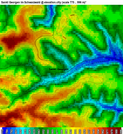
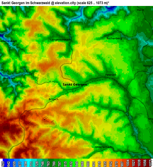
Below is the Elevation map of Sankt Georgen im Schwarzwald, which displays elevation range with different colors. Scale of the first map is from 775 to 996 m (2543 to 3268 ft) with average elevation of 879.6 meters (=2886 ft) [note 1]
These maps also provides idea of topography and contour of this city, they are displayed at different zoom levels. More info about maps, scale and edge coordinates you can find below images.
| \ | Map #1 | Map #2 | Topo.Map |
| Scale [m] | 775..996 m | 625..1073 m | × |
| Scale [ft] | 2543..3268 ft | 2051..3520 ft | × |
| Average | 879.6 m = 2886 ft | 858 m = 2815 ft | × |
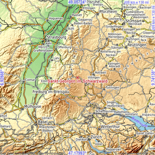
| Width | 6.52 km = 4.1 mi | 13.05 km = 8.1 mi | 208.7 km = 129.7 mi |
| Height | 6.52 km = 4.1 mi | 13.05 km = 8.1 mi | 208.7 km = 129.7 mi |
| ↑Max Latitude | 48.156484° | 48.185792° | 49.05724° |
| Latitude at center | 48.12716° | 48.12716° | 48.12716° |
| ↓Min Latitude | 48.097819° | 48.068461° | 47.17993° |
| ← Min Longitude | 8.291185° | 8.247239° | 6.92888° |
| Longitude center | 8.33513° | 8.33513° | 8.33513° |
| →Max Longitude | 8.379075° | 8.423021° | 9.74138° |
Nearby cities:
Cities around Sankt Georgen im Schwarzwald sort by population:
• Schramberg elevation 436 m
11.4 km,  19°
19°
• Königsfeld im Schwarzwald 761 m
6.4 km,  78°
78°
• Triberg 664 m
7.6 km,  273°
273°
• Hornberg 368 m
12 km,  320°
320°
• Schonach im Schwarzwald 850 m
10 km,  279°
279°
• Vöhrenbach 874 m
9 km,  196°
196°
• Tennenbronn 663 m
7.1 km,  9°
9°
• Lauterbach/Schwarzwald 615 m
11.4 km,  2°
2°
• Mönchweiler 783 m
7.1 km,  114°
114°
• Unterkirnach 805 m
5.8 km,  156°
156°
• Hardt 773 m
8.7 km,  44°
44°
• Schönwald 995 m
10 km,  256°
256°
Multilingual:
 En español:
Sankt Georgen im Schwarzwald elevación 852 m.
 En France:
Sankt Georgen im Schwarzwald élévation 852 m.
 Auf Deutsch:
Sankt Georgen im Schwarzwald höhe über dem Meeresspiegel ist 852 m.
 На русском:
Sankt Georgen im Schwarzwald высота над уровнем моря 852 м
Sources and notes:
- [note 1] Map square and city borders are not equal. Map elevation data is calculated only from area inside that square.
- [src 1] Elevation data from geonames database provided with same terms of usage.
- [src 2] The elevation map of Sankt Georgen im Schwarzwald is generated using elevation data from NASA's 3 arcsec (90m) resolution SRTM data.
- [src 3] Base (background) map © OpenStreetMap contributors tiles are generated by Geofabrik and OpenTopoMap.
Copyright & License:
This Sankt Georgen im Schwarzwald Elevation Map is licensed under CC BY-SA. You may reuse any part from this page, if you give a proper credit by linking to this URL:
 More info on terms of use page.