Schirmitz elevation
Schirmitz (Bavaria, Upper Palatinate), Germany elevation is 393 meters and Schirmitz elevation in feet is 1289 ft above sea level [src 1]. Schirmitz is a seat of a fourth-order administrative division (feature code) with elevation that is 135 meters (443 ft) bigger than average city elevation in Germany.
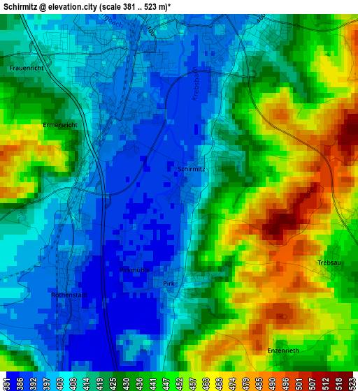
Below is the Elevation map of Schirmitz, which displays elevation range with different colors. Scale of the first map is from 381 to 523 m (1250 to 1716 ft) with average elevation of 425.6 meters (=1396 ft) [note 1]
These maps also provides idea of topography and contour of this city, they are displayed at different zoom levels. More info about maps, scale and edge coordinates you can find below images.
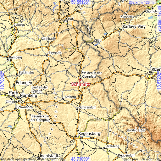
| \ | Map #1 | Topo.Map |
| Scale [m] | 381..523 m | × |
| Scale [ft] | 1250..1716 ft | × |
| Average | 425.6 m = 1396 ft | × |
| Width | 6.33 km = 3.9 mi | 202.5 km = 125.8 mi |
| Height | 6.33 km = 3.9 mi | 202.5 km = 125.8 mi |
| ↑Max Latitude | 49.678444° | 50.55198° |
| Latitude at center | 49.65° | 49.65° |
| ↓Min Latitude | 49.621539° | 48.73099° |
| ← Min Longitude | 12.122725° | 10.76042° |
| Longitude center | 12.16667° | 12.16667° |
| →Max Longitude | 12.210615° | 13.57292° |
Nearby cities:
Cities around Schirmitz sort by population:
• Weiden elevation 397 m
3.1 km,  345°
345°
• Neustadt an der Waldnaab 428 m
9.2 km,  4°
4°
• Weiherhammer 390 m
7.4 km,  255°
255°
• Luhe-Wildenau 394 m
7.5 km,  189°
189°
• Mantel 402 m
9.1 km,  272°
272°
• Pirk 404 m
1.9 km,  180°
180°
• Etzenricht 409 m
5.1 km,  248°
248°
• Störnstein 442 m
9.6 km,  16°
16°
• Leuchtenberg 563 m
8.8 km,  131°
131°
• Theisseil 545 m
6.3 km,  44°
44°
• Irchenrieth 431 m
5.2 km, 125°
• Bechtsrieth 447 m
3.2 km,  100°
100°
Multilingual:
 En español:
Schirmitz elevación 393 m.
 En France:
Schirmitz élévation 393 m.
 Auf Deutsch:
Schirmitz höhe über dem Meeresspiegel ist 393 m.

Sources and notes:
- [note 1] Map square and city borders are not equal. Map elevation data is calculated only from area inside that square.
- [src 1] Elevation data from geonames database provided with same terms of usage.
- [src 2] The elevation map of Schirmitz is generated using elevation data from NASA's 3 arcsec (90m) resolution SRTM data.
- [src 3] Base (background) map © OpenStreetMap contributors tiles are generated by Geofabrik and OpenTopoMap.
Copyright & License:
This Schirmitz Elevation Map is licensed under CC BY-SA. You may reuse any part from this page, if you give a proper credit by linking to this URL:
 More info on terms of use page.