Schlier elevation
Schlier (Baden-Württemberg, Tübingen Region), Germany elevation is 590 meters and Schlier elevation in feet is 1936 ft above sea level [src 1]. Schlier is a seat of a fourth-order administrative division (feature code) with elevation that is 332 meters (1089 ft) bigger than average city elevation in Germany.
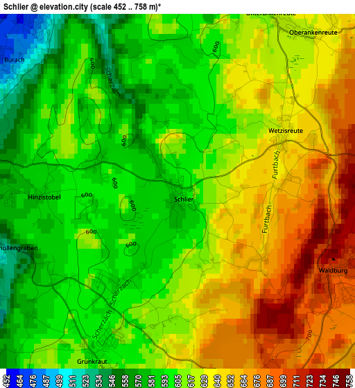
Below is the Elevation map of Schlier, which displays elevation range with different colors. Scale of the first map is from 452 to 758 m (1483 to 2487 ft) with average elevation of 618 meters (=2028 ft) [note 1]
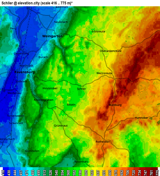
These maps also provides idea of topography and contour of this city, they are displayed at different zoom levels. More info about maps, scale and edge coordinates you can find below images.
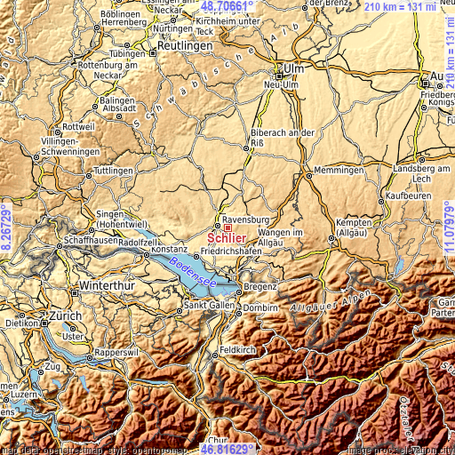
| \ | Map #1 | Map #2 | Topo.Map |
| Scale [m] | 452..758 m | 416..775 m | × |
| Scale [ft] | 1483..2487 ft | 1365..2543 ft | × |
| Average | 618 m = 2028 ft | 586.7 m = 1925 ft | × |
| Width | 6.57 km = 4.1 mi | 13.14 km = 8.2 mi | 210.2 km = 130.6 mi |
| Height | 6.57 km = 4.1 mi | 13.14 km = 8.2 mi | 210.2 km = 130.6 mi |
| ↑Max Latitude | 47.799568° | 47.829078° | 48.70661° |
| Latitude at center | 47.77004° | 47.77004° | 47.77004° |
| ↓Min Latitude | 47.740496° | 47.710934° | 46.81629° |
| ← Min Longitude | 9.629595° | 9.585649° | 8.26729° |
| Longitude center | 9.67354° | 9.67354° | 9.67354° |
| →Max Longitude | 9.717485° | 9.761431° | 11.07979° |
Nearby cities:
Cities around Schlier sort by population:
• Ravensburg elevation 447 m
4.9 km,  285°
285°
• Weingarten 461 m
5.2 km,  329°
329°
• Meckenbeuren 415 m
11.2 km,  225°
225°
• Baienfurt 462 m
6.7 km,  345°
345°
• Baindt 513 m
8.9 km,  356°
356°
• Vogt 662 m
7 km,  93°
93°
• Amtzell 559 m
9.7 km,  143°
143°
• Wolfegg 672 m
10.6 km,  58°
58°
• Bodnegg 601 m
6.8 km,  170°
170°
• Bergatreute 603 m
10.6 km,  32°
32°
• Grünkraut 601 m
3.2 km,  204°
204°
• Waldburg 710 m
3.3 km,  115°
115°
Multilingual:
 En español:
Schlier elevación 590 m.
 En France:
Schlier élévation 590 m.


Sources and notes:
- [note 1] Map square and city borders are not equal. Map elevation data is calculated only from area inside that square.
- [src 1] Elevation data from geonames database provided with same terms of usage.
- [src 2] The elevation map of Schlier is generated using elevation data from NASA's 3 arcsec (90m) resolution SRTM data.
- [src 3] Base (background) map © OpenStreetMap contributors tiles are generated by Geofabrik and OpenTopoMap.
Copyright & License:
This Schlier Elevation Map is licensed under CC BY-SA. You may reuse any part from this page, if you give a proper credit by linking to this URL:
 More info on terms of use page.