Schöppenstedt elevation
Schöppenstedt (Lower Saxony), Germany elevation is 109 meters and Schöppenstedt elevation in feet is 358 ft above sea level [src 1]. Schöppenstedt is a populated place (feature code) with elevation that is 149 meters (489 ft) smaller than average city elevation in Germany.
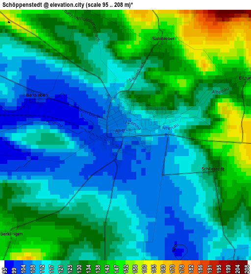
Below is the Elevation map of Schöppenstedt, which displays elevation range with different colors. Scale of the first map is from 95 to 208 m (312 to 682 ft) with average elevation of 124.8 meters (=409 ft) [note 1]
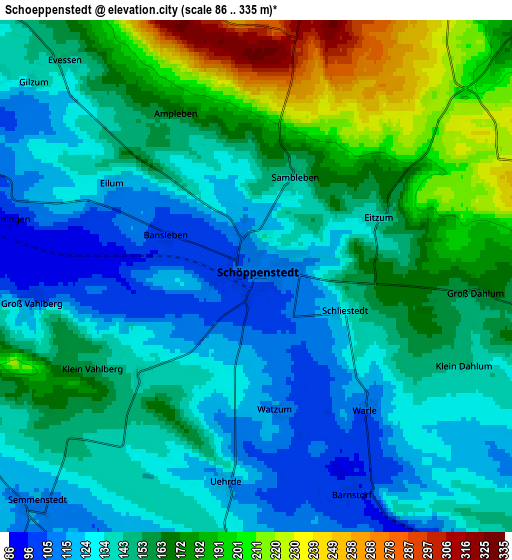
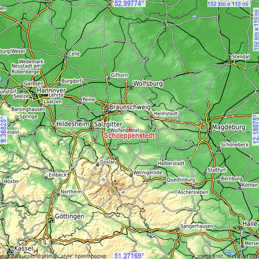
These maps also provides idea of topography and contour of this city, they are displayed at different zoom levels. More info about maps, scale and edge coordinates you can find below images.
| \ | Map #1 | Map #2 | Topo.Map |
| Scale [m] | 95..208 m | 86..335 m | × |
| Scale [ft] | 312..682 ft | 282..1099 ft | × |
| Average | 124.8 m = 409 ft | 151.6 m = 497 ft | × |
| Width | 6 km = 3.7 mi | 11.99 km = 7.5 mi | 191.9 km = 119.2 mi |
| Height | 6 km = 3.7 mi | 11.99 km = 7.5 mi | 191.9 km = 119.2 mi |
| ↑Max Latitude | 52.170041° | 52.196985° | 52.99774° |
| Latitude at center | 52.14308° | 52.14308° | 52.14308° |
| ↓Min Latitude | 52.116103° | 52.08911° | 51.27169° |
| ← Min Longitude | 10.730555° | 10.686609° | 9.36825° |
| Longitude center | 10.7745° | 10.7745° | 10.7745° |
| →Max Longitude | 10.818445° | 10.862391° | 12.18075° |
Nearby cities:
Cities around Schöppenstedt sort by population:
• Königslutter am Elm elevation 136 m
12.4 km,  13°
13°
• Sickte 110 m
12.3 km,  312°
312°
• Remlingen 137 m
7.6 km,  244°
244°
• Destedt 154 m
11.4 km,  337°
337°
• Evessen 146 m
6.7 km,  319°
319°
• Wittmar 122 m
9.3 km,  260°
260°
• Dettum 94 m
8 km,  294°
294°
• Jerxheim 129 m
10.9 km,  128°
128°
• Wolsdorf 136 m
12.4 km,  64°
64°
• Erkerode 176 m
8.2 km,  327°
327°
• Veltheim 129 m
10.5 km, 323°
• Uehrde 114 m
4.9 km,  187°
187°
Multilingual:
 En español:
Schöppenstedt elevación 109 m.
 En France:
Schöppenstedt élévation 109 m.
 Auf Deutsch:
Schöppenstedt höhe über dem Meeresspiegel ist 109 m.

Sources and notes:
- [note 1] Map square and city borders are not equal. Map elevation data is calculated only from area inside that square.
- [src 1] Elevation data from geonames database provided with same terms of usage.
- [src 2] The elevation map of Schöppenstedt is generated using elevation data from NASA's 3 arcsec (90m) resolution SRTM data.
- [src 3] Base (background) map © OpenStreetMap contributors tiles are generated by Geofabrik and OpenTopoMap.
Copyright & License:
This Schöppenstedt Elevation Map is licensed under CC BY-SA. You may reuse any part from this page, if you give a proper credit by linking to this URL:
 More info on terms of use page.