Schwabenheim elevation
Schwabenheim (Rheinland-Pfalz), Germany elevation is 127 meters and Schwabenheim elevation in feet is 417 ft above sea level [src 1]. Schwabenheim is a populated place (feature code) with elevation that is 131 meters (430 ft) smaller than average city elevation in Germany.
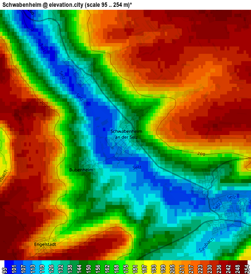
Below is the Elevation map of Schwabenheim, which displays elevation range with different colors. Scale of the first map is from 95 to 254 m (312 to 833 ft) with average elevation of 181.1 meters (=594 ft) [note 1]
These maps also provides idea of topography and contour of this city, they are displayed at different zoom levels. More info about maps, scale and edge coordinates you can find below images.
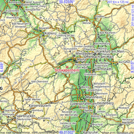
| \ | Map #1 | Topo.Map |
| Scale [m] | 95..254 m | × |
| Scale [ft] | 312..833 ft | × |
| Average | 181.1 m = 594 ft | × |
| Width | 6.29 km = 3.9 mi | 201.3 km = 125.1 mi |
| Height | 6.29 km = 3.9 mi | 201.3 km = 125.1 mi |
| ↑Max Latitude | 49.957071° | 50.82556° |
| Latitude at center | 49.92879° | 49.92879° |
| ↓Min Latitude | 49.900492° | 49.01502° |
| ← Min Longitude | 8.051305° | 6.689° |
| Longitude center | 8.09525° | 8.09525° |
| →Max Longitude | 8.139195° | 9.5015° |
Nearby cities:
Cities around Schwabenheim sort by population:
• Ingelheim am Rhein elevation 113 m
5.3 km,  330°
330°
• Nieder-Ingelheim 135 m
5.7 km,  343°
343°
• Nieder-Olm 136 m
8.1 km,  103°
103°
• Ober-Saulheim 157 m
7.8 km,  158°
158°
• Gau-Algesheim 107 m
6.5 km,  298°
298°
• Stadecken-Elsheim 110 m
2.8 km,  130°
130°
• Ober-Olm 221 m
6.8 km,  82°
82°
• Essenheim 219 m
4.3 km,  87°
87°
• Wackernheim 213 m
5.3 km,  16°
16°
• Jugenheim 160 m
4 km,  190°
190°
• Partenheim 184 m
5.1 km, 190°
• Appenheim 175 m
4.4 km,  271°
271°
Multilingual:
 En español:
Schwabenheim elevación 127 m.
 En France:
Schwabenheim élévation 127 m.
 Auf Deutsch:
Schwabenheim höhe über dem Meeresspiegel ist 127 m.

Sources and notes:
- [note 1] Map square and city borders are not equal. Map elevation data is calculated only from area inside that square.
- [src 1] Elevation data from geonames database provided with same terms of usage.
- [src 2] The elevation map of Schwabenheim is generated using elevation data from NASA's 3 arcsec (90m) resolution SRTM data.
- [src 3] Base (background) map © OpenStreetMap contributors tiles are generated by Geofabrik and OpenTopoMap.
Copyright & License:
This Schwabenheim Elevation Map is licensed under CC BY-SA. You may reuse any part from this page, if you give a proper credit by linking to this URL:
 More info on terms of use page.