Schwarzenbruck elevation
Schwarzenbruck (Bavaria, Regierungsbezirk Mittelfranken), Germany elevation is 364 meters and Schwarzenbruck elevation in feet is 1194 ft above sea level [src 1]. Schwarzenbruck is a seat of a fourth-order administrative division (feature code) with elevation that is 106 meters (348 ft) bigger than average city elevation in Germany.
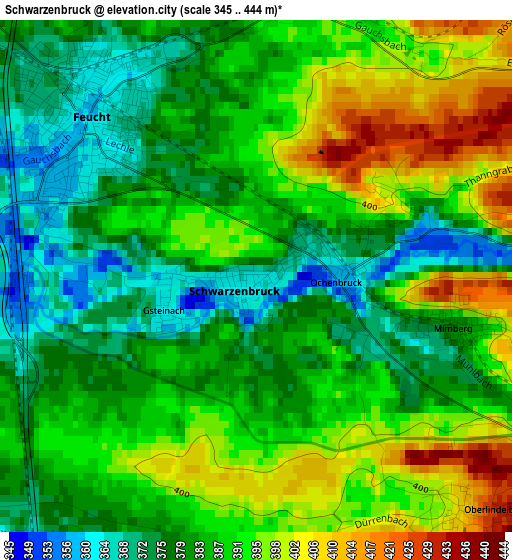
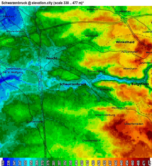
Below is the Elevation map of Schwarzenbruck, which displays elevation range with different colors. Scale of the first map is from 345 to 444 m (1132 to 1457 ft) with average elevation of 386.4 meters (=1268 ft) [note 1]
These maps also provides idea of topography and contour of this city, they are displayed at different zoom levels. More info about maps, scale and edge coordinates you can find below images.
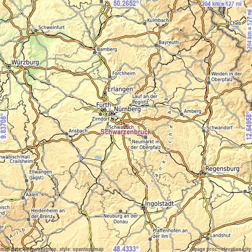
| \ | Map #1 | Map #2 | Topo.Map |
| Scale [m] | 345..444 m | 330..477 m | × |
| Scale [ft] | 1132..1457 ft | 1083..1565 ft | × |
| Average | 386.4 m = 1268 ft | 397.3 m = 1303 ft | × |
| Width | 6.37 km = 4 mi | 12.73 km = 7.9 mi | 203.7 km = 126.6 mi |
| Height | 6.37 km = 4 mi | 12.73 km = 7.9 mi | 203.7 km = 126.6 mi |
| ↑Max Latitude | 49.386395° | 49.414993° | 50.2652° |
| Latitude at center | 49.35778° | 49.35778° | 49.35778° |
| ↓Min Latitude | 49.329149° | 49.300501° | 48.4333° |
| ← Min Longitude | 11.199385° | 11.155439° | 9.83708° |
| Longitude center | 11.24333° | 11.24333° | 11.24333° |
| →Max Longitude | 11.287275° | 11.331221° | 12.64958° |
Nearby cities:
Cities around Schwarzenbruck sort by population:
• Wendelstein elevation 342 m
6.7 km,  264°
264°
• Altdorf 445 m
8.8 km,  69°
69°
• Feucht 359 m
2.9 km,  313°
313°
• Röthenbach an der Pegnitz 331 m
13.9 km,  359°
359°
• Burgthann 431 m
5 km,  97°
97°
• Schwaig 324 m
12.8 km,  346°
346°
• Allersberg 387 m
11.8 km,  182°
182°
• Postbauer-Heng 460 m
10.1 km,  125°
125°
• Rednitzhembach 326 m
13.4 km,  241°
241°
• Leinburg 397 m
11.5 km,  24°
24°
• Pyrbaum 439 m
7.5 km,  155°
155°
• Winkelhaid 423 m
5.4 km,  48°
48°
Multilingual:
 En español:
Schwarzenbruck elevación 364 m.
 En France:
Schwarzenbruck élévation 364 m.
 Auf Deutsch:
Schwarzenbruck höhe über dem Meeresspiegel ist 364 m.

Sources and notes:
- [note 1] Map square and city borders are not equal. Map elevation data is calculated only from area inside that square.
- [src 1] Elevation data from geonames database provided with same terms of usage.
- [src 2] The elevation map of Schwarzenbruck is generated using elevation data from NASA's 3 arcsec (90m) resolution SRTM data.
- [src 3] Base (background) map © OpenStreetMap contributors tiles are generated by Geofabrik and OpenTopoMap.
Copyright & License:
This Schwarzenbruck Elevation Map is licensed under CC BY-SA. You may reuse any part from this page, if you give a proper credit by linking to this URL:
 More info on terms of use page.