Schwarzhofen elevation
Schwarzhofen (Bavaria, Upper Palatinate), Germany elevation is 389 meters and Schwarzhofen elevation in feet is 1276 ft above sea level [src 1]. Schwarzhofen is a populated place (feature code) with elevation that is 131 meters (430 ft) bigger than average city elevation in Germany.
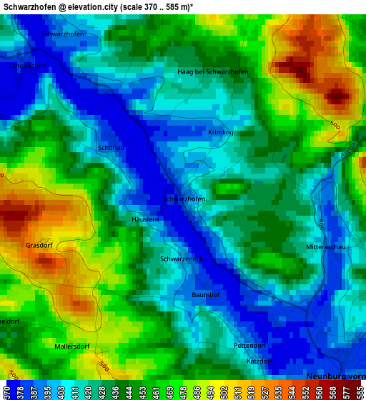
Below is the Elevation map of Schwarzhofen, which displays elevation range with different colors. Scale of the first map is from 370 to 585 m (1214 to 1919 ft) with average elevation of 438.1 meters (=1437 ft) [note 1]
These maps also provides idea of topography and contour of this city, they are displayed at different zoom levels. More info about maps, scale and edge coordinates you can find below images.
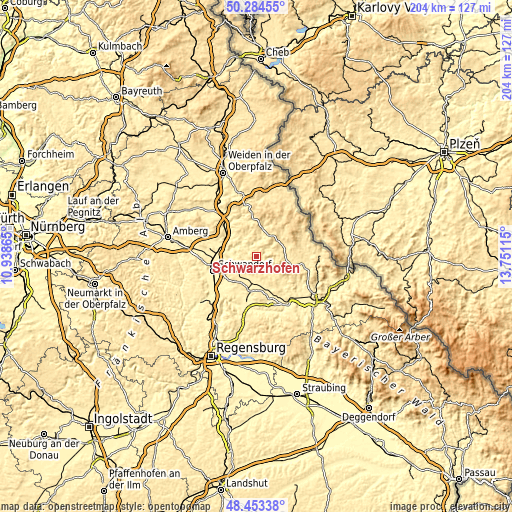
| \ | Map #1 | Topo.Map |
| Scale [m] | 370..585 m | × |
| Scale [ft] | 1214..1919 ft | × |
| Average | 438.1 m = 1437 ft | × |
| Width | 6.36 km = 4 mi | 203.6 km = 126.5 mi |
| Height | 6.36 km = 4 mi | 203.6 km = 126.5 mi |
| ↑Max Latitude | 49.406093° | 50.28455° |
| Latitude at center | 49.37749° | 49.37749° |
| ↓Min Latitude | 49.34887° | 48.45338° |
| ← Min Longitude | 12.300955° | 10.93865° |
| Longitude center | 12.3449° | 12.3449° |
| →Max Longitude | 12.388845° | 13.75115° |
Nearby cities:
Cities around Schwarzhofen sort by population:
• Neunburg vorm Wald elevation 390 m
4.5 km,  137°
137°
• Oberviechtach 506 m
10.4 km,  30°
30°
• Wackersdorf 452 m
13.5 km,  239°
239°
• Bodenwöhr 390 m
12.3 km,  194°
194°
• Pettendorf 390 m
2.7 km,  157°
157°
• Teunz 470 m
12.1 km,  13°
13°
• Bach 479 m
3.7 km,  48°
48°
• Winklarn 523 m
11.2 km,  60°
60°
• Niedermurach 420 m
8.4 km,  15°
15°
• Neukirchen-Balbini 507 m
11.7 km,  145°
145°
• Dieterskirchen 500 m
6.8 km, 50°
• Thanstein 577 m
8.8 km,  85°
85°
Multilingual:
 En español:
Schwarzhofen elevación 389 m.
 En France:
Schwarzhofen élévation 389 m.
 Auf Deutsch:
Schwarzhofen höhe über dem Meeresspiegel ist 389 m.

Sources and notes:
- [note 1] Map square and city borders are not equal. Map elevation data is calculated only from area inside that square.
- [src 1] Elevation data from geonames database provided with same terms of usage.
- [src 2] The elevation map of Schwarzhofen is generated using elevation data from NASA's 3 arcsec (90m) resolution SRTM data.
- [src 3] Base (background) map © OpenStreetMap contributors tiles are generated by Geofabrik and OpenTopoMap.
Copyright & License:
This Schwarzhofen Elevation Map is licensed under CC BY-SA. You may reuse any part from this page, if you give a proper credit by linking to this URL:
 More info on terms of use page.