Sipplingen elevation
Sipplingen (Baden-Württemberg, Tübingen Region), Germany elevation is 420 meters and Sipplingen elevation in feet is 1378 ft above sea level [src 1]. Sipplingen is a seat of a fourth-order administrative division (feature code) with elevation that is 162 meters (531 ft) bigger than average city elevation in Germany.
Below is the Elevation map of Sipplingen, which displays elevation range with different colors. Scale of the first map is from 392 to 712 m (1286 to 2336 ft) with average elevation of 489.6 meters (=1606 ft) [note 1]
These maps also provides idea of topography and contour of this city, they are displayed at different zoom levels. More info about maps, scale and edge coordinates you can find below images.
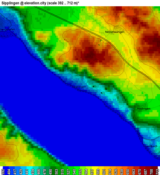
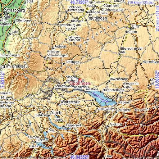
| \ | Map #1 | Topo.Map |
| Scale [m] | 392..712 m | × |
| Scale [ft] | 1286..2336 ft | × |
| Average | 489.6 m = 1606 ft | × |
| Width | 6.56 km = 4.1 mi | 210.1 km = 130.5 mi |
| Height | 6.56 km = 4.1 mi | 210.1 km = 130.5 mi |
| ↑Max Latitude | 47.826292° | 48.73287° |
| Latitude at center | 47.79678° | 47.79678° |
| ↓Min Latitude | 47.767251° | 46.84352° |
| ← Min Longitude | 9.053425° | 7.69112° |
| Longitude center | 9.09737° | 9.09737° |
| →Max Longitude | 9.141315° | 10.50362° |
Nearby cities:
Cities around Sipplingen sort by population:
• Radolfzell elevation 403 m
11.2 km,  237°
237°
• Überlingen 431 m
6.3 km,  118°
118°
• Stockach 474 m
8.9 km,  312°
312°
• Uhldingen-Mühlhofen 418 m
13.4 km, 121°
• Allensbach 403 m
9.3 km,  192°
192°
• Reichenau 409 m
12.3 km, 191°
• Steißlingen 465 m
12.3 km,  271°
271°
• Bodman-Ludwigshafen 405 m
3.9 km, 307°
• Owingen 533 m
5.7 km,  75°
75°
• Herdwangen-Schönach 606 m
9.7 km,  52°
52°
• Orsingen-Nenzingen 460 m
11.5 km,  296°
296°
• Frickingen 477 m
13.3 km, 81°
Multilingual:
 En español:
Sipplingen elevación 420 m.
 En France:
Sipplingen élévation 420 m.
 Auf Deutsch:
Sipplingen höhe über dem Meeresspiegel ist 420 m.

Sources and notes:
- [note 1] Map square and city borders are not equal. Map elevation data is calculated only from area inside that square.
- [src 1] Elevation data from geonames database provided with same terms of usage.
- [src 2] The elevation map of Sipplingen is generated using elevation data from NASA's 3 arcsec (90m) resolution SRTM data.
- [src 3] Base (background) map © OpenStreetMap contributors tiles are generated by Geofabrik and OpenTopoMap.
Copyright & License:
This Sipplingen Elevation Map is licensed under CC BY-SA. You may reuse any part from this page, if you give a proper credit by linking to this URL:
 More info on terms of use page.