Sohland elevation
Sohland (Saxony), Germany elevation is 316 meters and Sohland elevation in feet is 1037 ft above sea level [src 1]. Sohland is a populated place (feature code) with elevation that is 58 meters (190 ft) bigger than average city elevation in Germany.
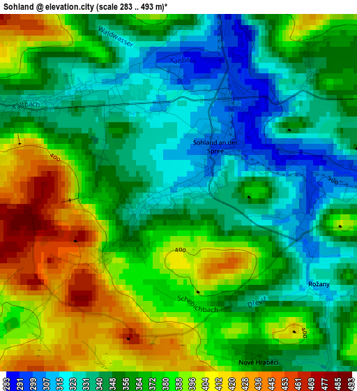
Below is the Elevation map of Sohland, which displays elevation range with different colors. Scale of the first map is from 283 to 493 m (928 to 1617 ft) with average elevation of 364.6 meters (=1196 ft) [note 1]
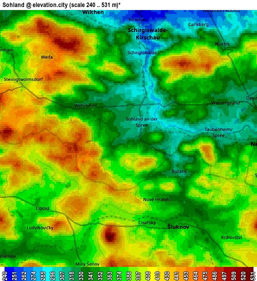
These maps also provides idea of topography and contour of this city, they are displayed at different zoom levels. More info about maps, scale and edge coordinates you can find below images.
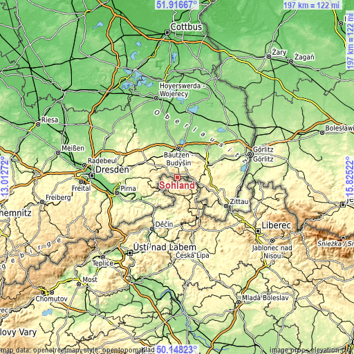
| \ | Map #1 | Map #2 | Topo.Map |
| Scale [m] | 283..493 m | 240..531 m | × |
| Scale [ft] | 928..1617 ft | 787..1742 ft | × |
| Average | 364.6 m = 1196 ft | 376.3 m = 1235 ft | × |
| Width | 6.14 km = 3.8 mi | 12.29 km = 7.6 mi | 196.6 km = 122.2 mi |
| Height | 6.14 km = 3.8 mi | 12.29 km = 7.6 mi | 196.6 km = 122.2 mi |
| ↑Max Latitude | 51.068513° | 51.09612° | 51.91667° |
| Latitude at center | 51.04089° | 51.04089° | 51.04089° |
| ↓Min Latitude | 51.01325° | 50.985594° | 50.14823° |
| ← Min Longitude | 14.375025° | 14.331079° | 13.01272° |
| Longitude center | 14.41897° | 14.41897° | 14.41897° |
| →Max Longitude | 14.462915° | 14.506861° | 15.82522° |
Nearby cities:
Cities around Sohland sort by population:
• Wilthen elevation 289 m
6.5 km,  343°
343°
• Cunewalde 290 m
9.5 km,  46°
46°
• Neukirch/Lausitz 322 m
10 km,  308°
308°
• Steinigtwolmsdorf 403 m
5.7 km,  295°
295°
• Großpostwitz 236 m
9 km,  9°
9°
• Oppach 332 m
6.3 km,  63°
63°
• Schirgiswalde 278 m
4 km, 9°
• Kirschau 245 m
5.9 km, 6°
• Neusalza-Spremberg 310 m
8.2 km,  91°
91°
• Crostau 301 m
5.5 km,  27°
27°
• Friedersdorf 335 m
10.2 km,  100°
100°
• Beiersdorf 386 m
9.1 km,  66°
66°
Multilingual:
 En español:
Sohland elevación 316 m.
 En France:
Sohland élévation 316 m.


Sources and notes:
- [note 1] Map square and city borders are not equal. Map elevation data is calculated only from area inside that square.
- [src 1] Elevation data from geonames database provided with same terms of usage.
- [src 2] The elevation map of Sohland is generated using elevation data from NASA's 3 arcsec (90m) resolution SRTM data.
- [src 3] Base (background) map © OpenStreetMap contributors tiles are generated by Geofabrik and OpenTopoMap.
Copyright & License:
This Sohland Elevation Map is licensed under CC BY-SA. You may reuse any part from this page, if you give a proper credit by linking to this URL:
 More info on terms of use page.