Spelle elevation
Spelle (Lower Saxony), Germany elevation is 35 meters and Spelle elevation in feet is 115 ft above sea level [src 1]. Spelle is a seat of a fourth-order administrative division (feature code) with elevation that is 223 meters (732 ft) smaller than average city elevation in Germany.
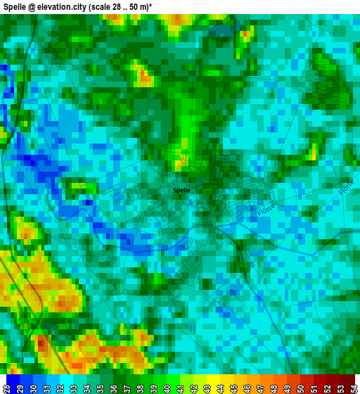
Below is the Elevation map of Spelle, which displays elevation range with different colors. Scale of the first map is from 28 to 50 m (92 to 164 ft) with average elevation of 34.5 meters (=113 ft) [note 1]
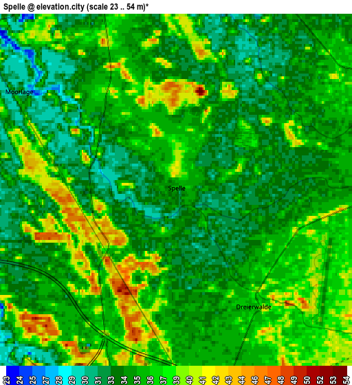
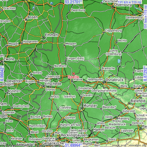
These maps also provides idea of topography and contour of this city, they are displayed at different zoom levels. More info about maps, scale and edge coordinates you can find below images.
| \ | Map #1 | Map #2 | Topo.Map |
| Scale [m] | 28..50 m | 23..54 m | × |
| Scale [ft] | 92..164 ft | 75..177 ft | × |
| Average | 34.5 m = 113 ft | 35.4 m = 116 ft | × |
| Width | 5.97 km = 3.7 mi | 11.93 km = 7.4 mi | 191 km = 118.7 mi |
| Height | 5.97 km = 3.7 mi | 11.93 km = 7.4 mi | 190.9 km = 118.6 mi |
| ↑Max Latitude | 52.393495° | 52.420304° | 53.21701° |
| Latitude at center | 52.36667° | 52.36667° | 52.36667° |
| ↓Min Latitude | 52.339829° | 52.312971° | 51.49964° |
| ← Min Longitude | 7.422725° | 7.378779° | 6.06042° |
| Longitude center | 7.46667° | 7.46667° | 7.46667° |
| →Max Longitude | 7.510615° | 7.554561° | 8.87292° |
Nearby cities:
Cities around Spelle sort by population:
• Rheine elevation 41 m
9.2 km,  191°
191°
• Hörstel 46 m
11.1 km,  133°
133°
• Neuenkirchen 64 m
15 km,  205°
205°
• Emsbüren 28 m
11.9 km,  288°
288°
• Salzbergen 31 m
8.7 km,  244°
244°
• Freren 41 m
14.3 km,  21°
21°
• Dreierwalde 36 m
4.6 km,  147°
147°
• Schapen 38 m
7.7 km,  61°
61°
• Thuine 51 m
14.9 km,  4°
4°
• Lünne 28 m
7.5 km,  338°
338°
• Beesten 33 m
7.7 km, 16°
• Messingen 41 m
11.1 km, 0°
Multilingual:
 En español:
Spelle elevación 35 m.
 En France:
Spelle élévation 35 m.


Sources and notes:
- [note 1] Map square and city borders are not equal. Map elevation data is calculated only from area inside that square.
- [src 1] Elevation data from geonames database provided with same terms of usage.
- [src 2] The elevation map of Spelle is generated using elevation data from NASA's 3 arcsec (90m) resolution SRTM data.
- [src 3] Base (background) map © OpenStreetMap contributors tiles are generated by Geofabrik and OpenTopoMap.
Copyright & License:
This Spelle Elevation Map is licensed under CC BY-SA. You may reuse any part from this page, if you give a proper credit by linking to this URL:
 More info on terms of use page.