Stadtprozelten elevation
Stadtprozelten (Bavaria, Regierungsbezirk Unterfranken), Germany elevation is 152 meters and Stadtprozelten elevation in feet is 499 ft above sea level [src 1]. Stadtprozelten is a populated place (feature code) with elevation that is 106 meters (348 ft) smaller than average city elevation in Germany.
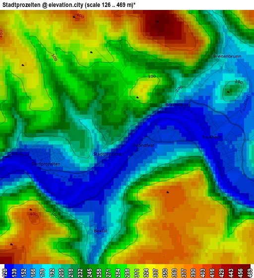
Below is the Elevation map of Stadtprozelten, which displays elevation range with different colors. Scale of the first map is from 126 to 469 m (413 to 1539 ft) with average elevation of 259.2 meters (=850 ft) [note 1]
These maps also provides idea of topography and contour of this city, they are displayed at different zoom levels. More info about maps, scale and edge coordinates you can find below images.
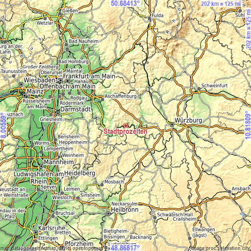
| \ | Map #1 | Topo.Map |
| Scale [m] | 126..469 m | × |
| Scale [ft] | 413..1539 ft | × |
| Average | 259.2 m = 850 ft | × |
| Width | 6.31 km = 3.9 mi | 201.9 km = 125.5 mi |
| Height | 6.31 km = 3.9 mi | 201.9 km = 125.5 mi |
| ↑Max Latitude | 49.813026° | 50.68413° |
| Latitude at center | 49.78466° | 49.78466° |
| ↓Min Latitude | 49.756278° | 48.86817° |
| ← Min Longitude | 9.367895° | 8.00559° |
| Longitude center | 9.41184° | 9.41184° |
| →Max Longitude | 9.455785° | 10.81809° |
Nearby cities:
Cities around Stadtprozelten sort by population:
• Wertheim elevation 174 m
7.5 km,  112°
112°
• Eschau 177 m
11.6 km,  289°
289°
• Freudenberg 157 m
7 km,  240°
240°
• Kreuzwertheim 150 m
7.9 km,  103°
103°
• Faulbach 140 m
2.3 km,  88°
88°
• Eichenbühl 179 m
10.6 km,  214°
214°
• Mönchberg 259 m
10.3 km,  275°
275°
• Esselbach 308 m
11.3 km,  46°
46°
• Dorfprozelten 145 m
2.3 km,  258°
258°
• Bischbrunn 405 m
11 km,  30°
30°
• Hasloch 137 m
5.9 km,  82°
82°
• Altenbuch 254 m
4.9 km,  351°
351°
Multilingual:
 En español:
Stadtprozelten elevación 152 m.
 En France:
Stadtprozelten élévation 152 m.
 Auf Deutsch:
Stadtprozelten höhe über dem Meeresspiegel ist 152 m.

Sources and notes:
- [note 1] Map square and city borders are not equal. Map elevation data is calculated only from area inside that square.
- [src 1] Elevation data from geonames database provided with same terms of usage.
- [src 2] The elevation map of Stadtprozelten is generated using elevation data from NASA's 3 arcsec (90m) resolution SRTM data.
- [src 3] Base (background) map © OpenStreetMap contributors tiles are generated by Geofabrik and OpenTopoMap.
Copyright & License:
This Stadtprozelten Elevation Map is licensed under CC BY-SA. You may reuse any part from this page, if you give a proper credit by linking to this URL:
 More info on terms of use page.