Süplingen elevation
Süplingen (Saxony-Anhalt), Germany elevation is 91 meters and Süplingen elevation in feet is 299 ft above sea level [src 1]. Süplingen is a seat of a fourth-order administrative division (feature code) with elevation that is 167 meters (548 ft) smaller than average city elevation in Germany.
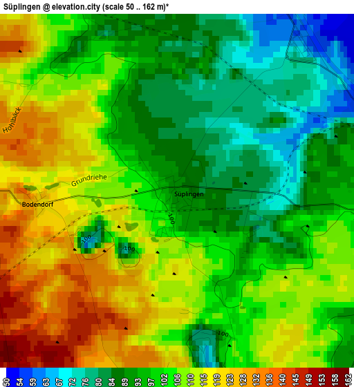
Below is the Elevation map of Süplingen, which displays elevation range with different colors. Scale of the first map is from 50 to 162 m (164 to 531 ft) with average elevation of 102.4 meters (=336 ft) [note 1]
These maps also provides idea of topography and contour of this city, they are displayed at different zoom levels. More info about maps, scale and edge coordinates you can find below images.
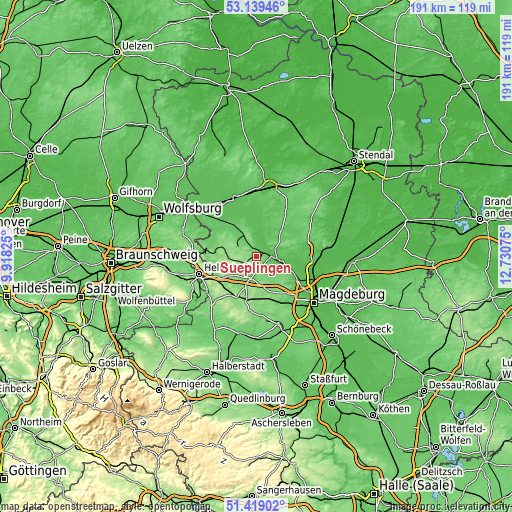
| \ | Map #1 | Topo.Map |
| Scale [m] | 50..162 m | × |
| Scale [ft] | 164..531 ft | × |
| Average | 102.4 m = 336 ft | × |
| Width | 5.98 km = 3.7 mi | 191.3 km = 118.9 mi |
| Height | 5.98 km = 3.7 mi | 191.3 km = 118.9 mi |
| ↑Max Latitude | 52.314463° | 53.13946° |
| Latitude at center | 52.28759° | 52.28759° |
| ↓Min Latitude | 52.260701° | 51.41902° |
| ← Min Longitude | 11.280555° | 9.91825° |
| Longitude center | 11.3245° | 11.3245° |
| →Max Longitude | 11.368445° | 12.73075° |
Nearby cities:
Cities around Süplingen sort by population:
• Haldensleben I elevation 54 m
5.8 km,  88°
88°
• Irxleben 124 m
17.1 km,  141°
141°
• Wefensleben 123 m
16.1 km,  223°
223°
• Samswegen 50 m
16.4 km,  100°
100°
• Flechtingen 101 m
7.4 km,  310°
310°
• Calvörde 59 m
12.2 km,  350°
350°
• Hermsdorf 131 m
15.2 km, 137°
• Hohenwarsleben 131 m
17 km, 135°
• Groß Ammensleben 62 m
14.8 km,  114°
114°
• Erxleben 141 m
9.5 km, 215°
• Eichenbarleben 112 m
14.4 km,  158°
158°
• Groß Santersleben 118 m
13.9 km, 140°
Multilingual:
 En español:
Süplingen elevación 91 m.
 En France:
Süplingen élévation 91 m.
 Auf Deutsch:
Süplingen höhe über dem Meeresspiegel ist 91 m.

Sources and notes:
- [note 1] Map square and city borders are not equal. Map elevation data is calculated only from area inside that square.
- [src 1] Elevation data from geonames database provided with same terms of usage.
- [src 2] The elevation map of Süplingen is generated using elevation data from NASA's 3 arcsec (90m) resolution SRTM data.
- [src 3] Base (background) map © OpenStreetMap contributors tiles are generated by Geofabrik and OpenTopoMap.
Copyright & License:
This Süplingen Elevation Map is licensed under CC BY-SA. You may reuse any part from this page, if you give a proper credit by linking to this URL:
 More info on terms of use page.