Tegernheim elevation
Tegernheim (Bavaria, Upper Palatinate), Germany elevation is 332 meters and Tegernheim elevation in feet is 1089 ft above sea level [src 1]. Tegernheim is a seat of a fourth-order administrative division (feature code) with elevation that is 74 meters (243 ft) bigger than average city elevation in Germany.
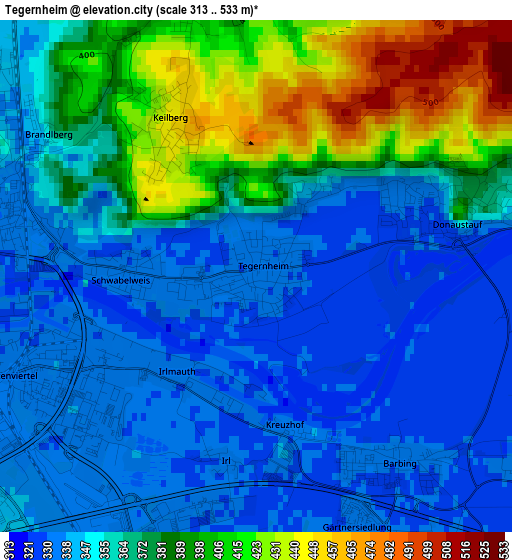
Below is the Elevation map of Tegernheim, which displays elevation range with different colors. Scale of the first map is from 313 to 533 m (1027 to 1749 ft) with average elevation of 364.4 meters (=1196 ft) [note 1]
These maps also provides idea of topography and contour of this city, they are displayed at different zoom levels. More info about maps, scale and edge coordinates you can find below images.
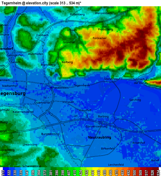
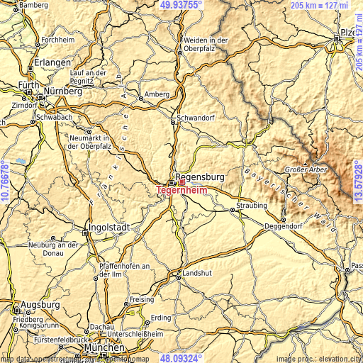
| \ | Map #1 | Map #2 | Topo.Map |
| Scale [m] | 313..533 m | 313..534 m | × |
| Scale [ft] | 1027..1749 ft | 1027..1752 ft | × |
| Average | 364.4 m = 1196 ft | 367.5 m = 1206 ft | × |
| Width | 6.41 km = 4 mi | 12.82 km = 8 mi | 205.1 km = 127.4 mi |
| Height | 6.41 km = 4 mi | 12.82 km = 8 mi | 205.1 km = 127.4 mi |
| ↑Max Latitude | 49.052749° | 49.08154° | 49.93755° |
| Latitude at center | 49.02394° | 49.02394° | 49.02394° |
| ↓Min Latitude | 48.995115° | 48.966273° | 48.09324° |
| ← Min Longitude | 12.129085° | 12.085139° | 10.76678° |
| Longitude center | 12.17303° | 12.17303° | 12.17303° |
| →Max Longitude | 12.216975° | 12.260921° | 13.57928° |
Nearby cities:
Cities around Tegernheim sort by population:
• Regensburg elevation 341 m
5.3 km,  259°
259°
• Lappersdorf 344 m
6.5 km,  293°
293°
• Neutraubling 332 m
4.5 km,  153°
153°
• Reinhausen 339 m
4.4 km,  280°
280°
• Wenzenbach 358 m
6.1 km,  18°
18°
• Obertraubling 339 m
6.4 km,  184°
184°
• Zeitlarn 334 m
7.5 km,  323°
323°
• Bernhardswald 453 m
9.2 km,  35°
35°
• Pentling 410 m
9.5 km,  241°
241°
• Barbing 329 m
3.3 km,  143°
143°
• Mintraching 331 m
9.3 km, 147°
• Donaustauf 340 m
2.5 km,  67°
67°
Multilingual:
 En español:
Tegernheim elevación 332 m.
 En France:
Tegernheim élévation 332 m.
 Auf Deutsch:
Tegernheim höhe über dem Meeresspiegel ist 332 m.

Sources and notes:
- [note 1] Map square and city borders are not equal. Map elevation data is calculated only from area inside that square.
- [src 1] Elevation data from geonames database provided with same terms of usage.
- [src 2] The elevation map of Tegernheim is generated using elevation data from NASA's 3 arcsec (90m) resolution SRTM data.
- [src 3] Base (background) map © OpenStreetMap contributors tiles are generated by Geofabrik and OpenTopoMap.
Copyright & License:
This Tegernheim Elevation Map is licensed under CC BY-SA. You may reuse any part from this page, if you give a proper credit by linking to this URL:
 More info on terms of use page.