Thierhaupten elevation
Thierhaupten (Bavaria, Swabia), Germany elevation is 427 meters and Thierhaupten elevation in feet is 1401 ft above sea level [src 1]. Thierhaupten is a populated place (feature code) with elevation that is 169 meters (554 ft) bigger than average city elevation in Germany.
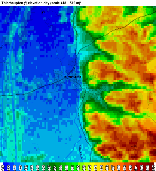
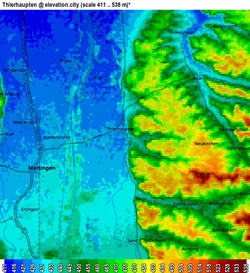
Below is the Elevation map of Thierhaupten, which displays elevation range with different colors. Scale of the first map is from 418 to 512 m (1371 to 1680 ft) with average elevation of 449.9 meters (=1476 ft) [note 1]
These maps also provides idea of topography and contour of this city, they are displayed at different zoom levels. More info about maps, scale and edge coordinates you can find below images.
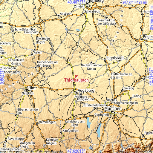
| \ | Map #1 | Map #2 | Topo.Map |
| Scale [m] | 418..512 m | 411..538 m | × |
| Scale [ft] | 1371..1680 ft | 1348..1765 ft | × |
| Average | 449.9 m = 1476 ft | 447 m = 1467 ft | × |
| Width | 6.47 km = 4 mi | 12.93 km = 8 mi | 207 km = 128.6 mi |
| Height | 6.47 km = 4 mi | 12.93 km = 8 mi | 206.9 km = 128.6 mi |
| ↑Max Latitude | 48.594383° | 48.62344° | 49.48737° |
| Latitude at center | 48.56531° | 48.56531° | 48.56531° |
| ↓Min Latitude | 48.53622° | 48.507114° | 47.62613° |
| ← Min Longitude | 10.864675° | 10.820729° | 9.50237° |
| Longitude center | 10.90862° | 10.90862° | 10.90862° |
| →Max Longitude | 10.952565° | 10.996511° | 12.31487° |
Nearby cities:
Cities around Thierhaupten sort by population:
• Meitingen elevation 432 m
4.7 km,  242°
242°
• Langweid 449 m
9.2 km,  206°
206°
• Aindling 457 m
6.6 km,  150°
150°
• Biberbach 438 m
8.9 km,  233°
233°
• Rehling 502 m
9.3 km,  168°
168°
• Oberndorf 408 m
11.9 km,  345°
345°
• Nordendorf 422 m
6.5 km,  300°
300°
• Petersdorf 485 m
10.7 km,  120°
120°
• Westendorf 427 m
5.1 km,  278°
278°
• Todtenweis 448 m
5.6 km,  164°
164°
• Ehingen 448 m
8.9 km, 295°
• Ellgau 420 m
4.9 km,  321°
321°
Multilingual:
 En español:
Thierhaupten elevación 427 m.
 En France:
Thierhaupten élévation 427 m.
 Auf Deutsch:
Thierhaupten höhe über dem Meeresspiegel ist 427 m.

Sources and notes:
- [note 1] Map square and city borders are not equal. Map elevation data is calculated only from area inside that square.
- [src 1] Elevation data from geonames database provided with same terms of usage.
- [src 2] The elevation map of Thierhaupten is generated using elevation data from NASA's 3 arcsec (90m) resolution SRTM data.
- [src 3] Base (background) map © OpenStreetMap contributors tiles are generated by Geofabrik and OpenTopoMap.
Copyright & License:
This Thierhaupten Elevation Map is licensed under CC BY-SA. You may reuse any part from this page, if you give a proper credit by linking to this URL:
 More info on terms of use page.