Ulm elevation
Ulm (Baden-Württemberg, Tübingen Region), Germany elevation is 480 meters and Ulm elevation in feet is 1575 ft above sea level [src 1]. Ulm is a seat of a third-order administrative division (feature code) with elevation that is 222 meters (728 ft) bigger than average city elevation in Germany.
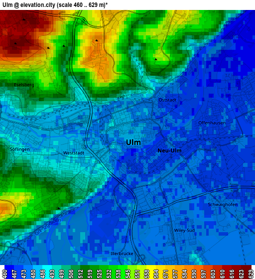
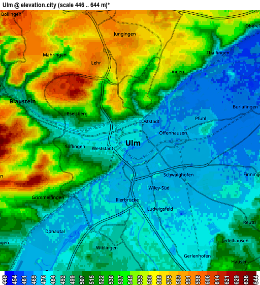
Below is the Elevation map of Ulm, which displays elevation range with different colors. Scale of the first map is from 460 to 629 m (1509 to 2064 ft) with average elevation of 497.6 meters (=1633 ft) [note 1]
These maps also provides idea of topography and contour of this city, they are displayed at different zoom levels. More info about maps, scale and edge coordinates you can find below images.
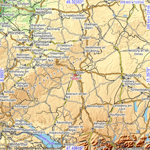
| \ | Map #1 | Map #2 | Topo.Map |
| Scale [m] | 460..629 m | 446..644 m | × |
| Scale [ft] | 1509..2064 ft | 1463..2113 ft | × |
| Average | 497.6 m = 1633 ft | 513.8 m = 1686 ft | × |
| Width | 6.49 km = 4 mi | 12.98 km = 8.1 mi | 207.6 km = 129 mi |
| Height | 6.49 km = 4 mi | 12.98 km = 8.1 mi | 207.6 km = 129 mi |
| ↑Max Latitude | 48.427579° | 48.456731° | 49.32353° |
| Latitude at center | 48.39841° | 48.39841° | 48.39841° |
| ↓Min Latitude | 48.369224° | 48.340022° | 47.45616° |
| ← Min Longitude | 9.947605° | 9.903659° | 8.5853° |
| Longitude center | 9.99155° | 9.99155° | 9.99155° |
| →Max Longitude | 10.035495° | 10.079441° | 11.3978° |
Nearby cities:
Cities around Ulm sort by population:
• Neu-Ulm elevation 474 m
1.6 km,  113°
113°
• Senden 487 m
9.1 km,  154°
154°
• Klingenstein 498 m
6.6 km,  289°
289°
• Erbach 484 m
10.9 km,  224°
224°
• Nersingen 462 m
10.3 km,  71°
71°
• Dornstadt 594 m
8.4 km,  335°
335°
• Pfaffenhofen an der Roth 488 m
13.5 km, 111°
• Staig 499 m
10.9 km,  180°
180°
• Beimerstetten 586 m
9.5 km,  356°
356°
• Bernstadt 561 m
11.5 km,  12°
12°
• Holzheim 474 m
8.2 km,  101°
101°
• Hüttisheim 510 m
13.7 km,  195°
195°
Multilingual:
 En español:
Ulm elevación 480 m.
 En France:
Ulm élévation 480 m.


Sources and notes:
- [note 1] Map square and city borders are not equal. Map elevation data is calculated only from area inside that square.
- [src 1] Elevation data from geonames database provided with same terms of usage.
- [src 2] The elevation map of Ulm is generated using elevation data from NASA's 3 arcsec (90m) resolution SRTM data.
- [src 3] Base (background) map © OpenStreetMap contributors tiles are generated by Geofabrik and OpenTopoMap.
Copyright & License:
This Ulm Elevation Map is licensed under CC BY-SA. You may reuse any part from this page, if you give a proper credit by linking to this URL:
 More info on terms of use page.