Unterschleißheim elevation
Unterschleißheim (Bavaria, Upper Bavaria), Germany elevation is 472 meters and Unterschleißheim elevation in feet is 1549 ft above sea level [src 1]. Unterschleißheim is a populated place (feature code) with elevation that is 214 meters (702 ft) bigger than average city elevation in Germany.
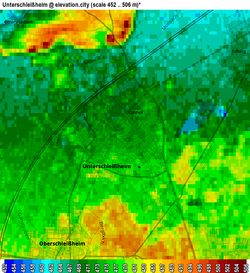
Below is the Elevation map of Unterschleißheim, which displays elevation range with different colors. Scale of the first map is from 452 to 506 m (1483 to 1660 ft) with average elevation of 474.6 meters (=1557 ft) [note 1]
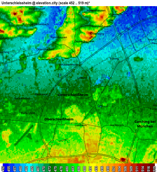
These maps also provides idea of topography and contour of this city, they are displayed at different zoom levels. More info about maps, scale and edge coordinates you can find below images.
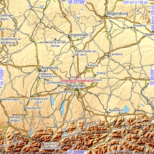
| \ | Map #1 | Map #2 | Topo.Map |
| Scale [m] | 452..506 m | 452..519 m | × |
| Scale [ft] | 1483..1660 ft | 1483..1703 ft | × |
| Average | 474.6 m = 1557 ft | 476.4 m = 1563 ft | × |
| Width | 6.5 km = 4 mi | 13.01 km = 8.1 mi | 208.1 km = 129.3 mi |
| Height | 6.5 km = 4 mi | 13.01 km = 8.1 mi | 208.1 km = 129.3 mi |
| ↑Max Latitude | 48.309617° | 48.338836° | 49.20766° |
| Latitude at center | 48.28038° | 48.28038° | 48.28038° |
| ↓Min Latitude | 48.251127° | 48.221857° | 47.33596° |
| ← Min Longitude | 11.532895° | 11.488949° | 10.17059° |
| Longitude center | 11.57684° | 11.57684° | 11.57684° |
| →Max Longitude | 11.620785° | 11.664731° | 12.98309° |
Nearby cities:
Cities around Unterschleißheim sort by population:
• Dachau elevation 502 m
10.8 km,  257°
257°
• Neufahrn bei Freising 462 m
7.5 km,  58°
58°
• Karlsfeld 488 m
9.6 km,  231°
231°
• Garching bei München 485 m
6.5 km,  122°
122°
• Ismaning 488 m
9.5 km, 123°
• Eching 467 m
3.7 km,  53°
53°
• Oberschleißheim 488 m
3.5 km,  192°
192°
• Unterföhring 505 m
10.9 km,  153°
153°
• Röhrmoos 494 m
11.1 km,  299°
299°
• Hebertshausen 480 m
8.3 km,  277°
277°
• Haimhausen 474 m
4.2 km,  337°
337°
• Fahrenzhausen 458 m
8.3 km,  348°
348°
Multilingual:
 En español:
Unterschleißheim elevación 472 m.
 En France:
Unterschleißheim élévation 472 m.
 Auf Deutsch:
Unterschleißheim höhe über dem Meeresspiegel ist 472 m.

Sources and notes:
- [note 1] Map square and city borders are not equal. Map elevation data is calculated only from area inside that square.
- [src 1] Elevation data from geonames database provided with same terms of usage.
- [src 2] The elevation map of Unterschleißheim is generated using elevation data from NASA's 3 arcsec (90m) resolution SRTM data.
- [src 3] Base (background) map © OpenStreetMap contributors tiles are generated by Geofabrik and OpenTopoMap.
Copyright & License:
This Unterschleißheim Elevation Map is licensed under CC BY-SA. You may reuse any part from this page, if you give a proper credit by linking to this URL:
 More info on terms of use page.