Uttenreuth elevation
Uttenreuth (Bavaria, Regierungsbezirk Mittelfranken), Germany elevation is 294 meters and Uttenreuth elevation in feet is 965 ft above sea level [src 1]. Uttenreuth is a seat of a fourth-order administrative division (feature code) with elevation that is 36 meters (118 ft) bigger than average city elevation in Germany.
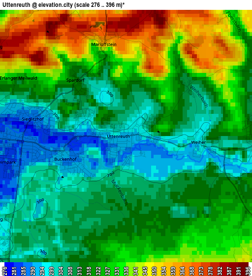
Below is the Elevation map of Uttenreuth, which displays elevation range with different colors. Scale of the first map is from 276 to 396 m (906 to 1299 ft) with average elevation of 320.9 meters (=1053 ft) [note 1]
These maps also provides idea of topography and contour of this city, they are displayed at different zoom levels. More info about maps, scale and edge coordinates you can find below images.
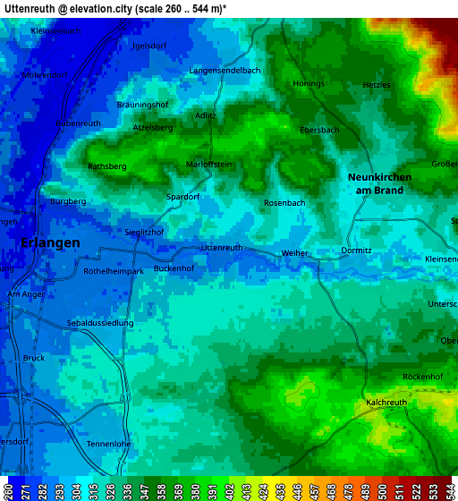
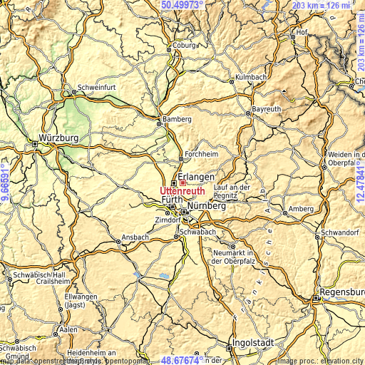
| \ | Map #1 | Map #2 | Topo.Map |
| Scale [m] | 276..396 m | 260..544 m | × |
| Scale [ft] | 906..1299 ft | 853..1785 ft | × |
| Average | 320.9 m = 1053 ft | 325.4 m = 1068 ft | × |
| Width | 6.33 km = 3.9 mi | 12.67 km = 7.9 mi | 202.7 km = 126 mi |
| Height | 6.33 km = 3.9 mi | 12.67 km = 7.9 mi | 202.7 km = 126 mi |
| ↑Max Latitude | 49.625225° | 49.653684° | 50.49973° |
| Latitude at center | 49.59675° | 49.59675° | 49.59675° |
| ↓Min Latitude | 49.568258° | 49.539749° | 48.67674° |
| ← Min Longitude | 11.028215° | 10.984269° | 9.66591° |
| Longitude center | 11.07216° | 11.07216° | 11.07216° |
| →Max Longitude | 11.116105° | 11.160051° | 12.47841° |
Nearby cities:
Cities around Uttenreuth sort by population:
• Erlangen elevation 290 m
4.7 km,  262°
262°
• Neunkirchen am Brand 316 m
4.5 km,  67°
67°
• Bubenreuth 281 m
5.2 km,  310°
310°
• Möhrendorf 272 m
6.6 km, 308°
• Buckenhof 289 m
1.6 km, 256°
• Kalchreuth 414 m
6.2 km,  134°
134°
• Langensendelbach 295 m
4.9 km,  359°
359°
• Dormitz 308 m
3.3 km,  87°
87°
• Spardorf 314 m
1.8 km,  318°
318°
• Marloffstein 364 m
2.4 km,  344°
344°
• Kleinsendelbach 312 m
6.2 km, 91°
• Hetzles 346 m
6 km,  47°
47°
Multilingual:
 En español:
Uttenreuth elevación 294 m.
 En France:
Uttenreuth élévation 294 m.
 Auf Deutsch:
Uttenreuth höhe über dem Meeresspiegel ist 294 m.

Sources and notes:
- [note 1] Map square and city borders are not equal. Map elevation data is calculated only from area inside that square.
- [src 1] Elevation data from geonames database provided with same terms of usage.
- [src 2] The elevation map of Uttenreuth is generated using elevation data from NASA's 3 arcsec (90m) resolution SRTM data.
- [src 3] Base (background) map © OpenStreetMap contributors tiles are generated by Geofabrik and OpenTopoMap.
Copyright & License:
This Uttenreuth Elevation Map is licensed under CC BY-SA. You may reuse any part from this page, if you give a proper credit by linking to this URL:
 More info on terms of use page.