Velden elevation
Velden (Bavaria, Lower Bavaria), Germany elevation is 480 meters and Velden elevation in feet is 1575 ft above sea level [src 1]. Velden is a populated place (feature code) with elevation that is 222 meters (728 ft) bigger than average city elevation in Germany.
Below is the Elevation map of Velden, which displays elevation range with different colors. Scale of the first map is from 445 to 531 m (1460 to 1742 ft) with average elevation of 472.1 meters (=1549 ft) [note 1]
These maps also provides idea of topography and contour of this city, they are displayed at different zoom levels. More info about maps, scale and edge coordinates you can find below images.
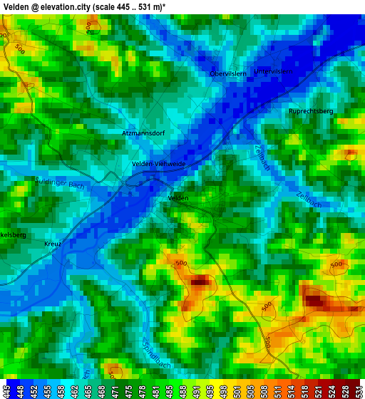
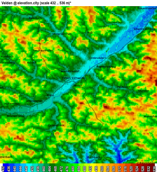
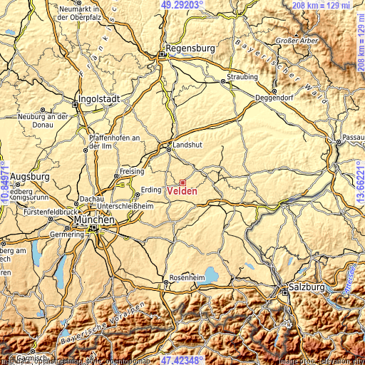
| \ | Map #1 | Map #2 | Topo.Map |
| Scale [m] | 445..531 m | 432..536 m | × |
| Scale [ft] | 1460..1742 ft | 1417..1759 ft | × |
| Average | 472.1 m = 1549 ft | 476.1 m = 1562 ft | × |
| Width | 6.49 km = 4 mi | 12.99 km = 8.1 mi | 207.8 km = 129.1 mi |
| Height | 6.49 km = 4 mi | 12.99 km = 8.1 mi | 207.7 km = 129.1 mi |
| ↑Max Latitude | 48.395507° | 48.424678° | 49.29203° |
| Latitude at center | 48.36632° | 48.36632° | 48.36632° |
| ↓Min Latitude | 48.337116° | 48.307895° | 47.42348° |
| ← Min Longitude | 12.212015° | 12.168069° | 10.84971° |
| Longitude center | 12.25596° | 12.25596° | 12.25596° |
| →Max Longitude | 12.299905° | 12.343851° | 13.66221° |
Nearby cities:
Cities around Velden sort by population:
• Taufkirchen elevation 490 m
9.3 km,  258°
258°
• Bodenkirchen 480 m
9.6 km,  78°
78°
• Eging 478 m
11.8 km,  335°
335°
• Schwindegg 432 m
10.5 km,  178°
178°
• Furth 477 m
10.3 km,  64°
64°
• Buchbach 452 m
6.1 km,  167°
167°
• Obertaufkirchen 469 m
11.9 km, 171°
• Altfraunhofen 460 m
11.4 km,  324°
324°
• Aham 465 m
7.3 km,  253°
253°
• Hohenpolding 495 m
9.3 km,  281°
281°
• Wurmsham 507 m
6 km,  107°
107°
• Neufraunhofen 490 m
4.7 km, 322°
Multilingual:
 En español:
Velden elevación 480 m.
 En France:
Velden élévation 480 m.


Sources and notes:
- [note 1] Map square and city borders are not equal. Map elevation data is calculated only from area inside that square.
- [src 1] Elevation data from geonames database provided with same terms of usage.
- [src 2] The elevation map of Velden is generated using elevation data from NASA's 3 arcsec (90m) resolution SRTM data.
- [src 3] Base (background) map © OpenStreetMap contributors tiles are generated by Geofabrik and OpenTopoMap.
Copyright & License:
This Velden Elevation Map is licensed under CC BY-SA. You may reuse any part from this page, if you give a proper credit by linking to this URL:
 More info on terms of use page.