Wattmannshagen elevation
Wattmannshagen (Mecklenburg-Vorpommern), Germany elevation is 34 meters and Wattmannshagen elevation in feet is 112 ft above sea level [src 1]. Wattmannshagen is a populated place (feature code) with elevation that is 224 meters (735 ft) smaller than average city elevation in Germany.
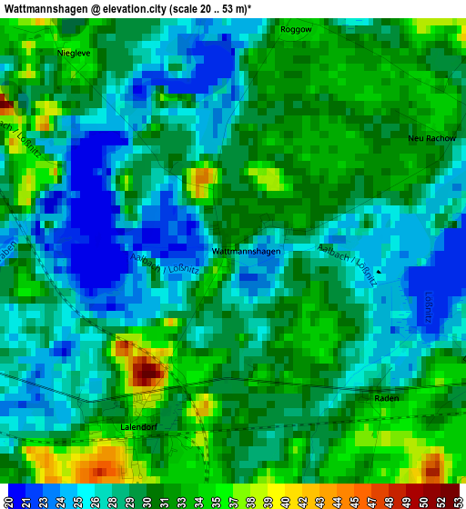
Below is the Elevation map of Wattmannshagen, which displays elevation range with different colors. Scale of the first map is from 20 to 53 m (66 to 174 ft) with average elevation of 29.7 meters (=97 ft) [note 1]
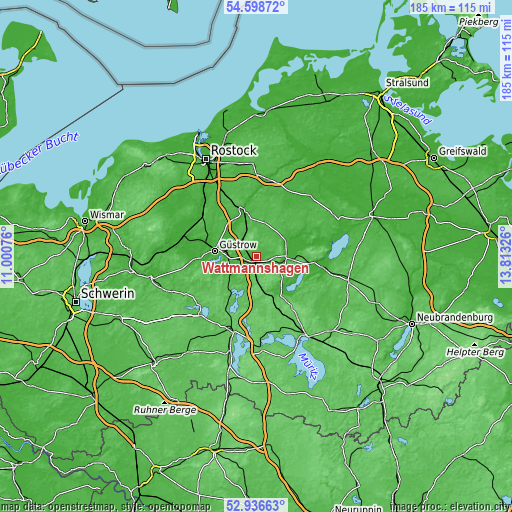
These maps also provides idea of topography and contour of this city, they are displayed at different zoom levels. More info about maps, scale and edge coordinates you can find below images.
| \ | Map #1 | Topo.Map |
| Scale [m] | 20..53 m | × |
| Scale [ft] | 66..174 ft | × |
| Average | 29.7 m = 97 ft | × |
| Width | 5.77 km = 3.6 mi | 184.8 km = 114.8 mi |
| Height | 5.77 km = 3.6 mi | 184.8 km = 114.8 mi |
| ↑Max Latitude | 53.801861° | 54.59872° |
| Latitude at center | 53.7759° | 53.7759° |
| ↓Min Latitude | 53.749923° | 52.93663° |
| ← Min Longitude | 12.363065° | 11.00076° |
| Longitude center | 12.40701° | 12.40701° |
| →Max Longitude | 12.450955° | 13.81326° |
Nearby cities:
Cities around Wattmannshagen sort by population:
• Güstrow elevation 9 m
15.5 km,  278°
278°
• Teterow 8 m
11 km,  90°
90°
• Malchin 10 m
23.9 km,  99°
99°
• Laage 24 m
17.1 km,  346°
346°
• Krakow am See 51 m
16.5 km,  213°
213°
• Pampow 43 m
13.4 km, 99°
• Lalendorf 36 m
2.3 km, 209°
• Gielow 18 m
23.9 km,  111°
111°
• Jördenstorf 50 m
17.8 km,  50°
50°
• Mühl Rosin 17 m
12.8 km,  263°
263°
• Groß Wokern 47 m
6.2 km,  115°
115°
• Wardow 33 m
17.2 km,  0°
0°
Multilingual:
 En español:
Wattmannshagen elevación 34 m.
 En France:
Wattmannshagen élévation 34 m.
 Auf Deutsch:
Wattmannshagen höhe über dem Meeresspiegel ist 34 m.

Sources and notes:
- [note 1] Map square and city borders are not equal. Map elevation data is calculated only from area inside that square.
- [src 1] Elevation data from geonames database provided with same terms of usage.
- [src 2] The elevation map of Wattmannshagen is generated using elevation data from NASA's 3 arcsec (90m) resolution SRTM data.
- [src 3] Base (background) map © OpenStreetMap contributors tiles are generated by Geofabrik and OpenTopoMap.
Copyright & License:
This Wattmannshagen Elevation Map is licensed under CC BY-SA. You may reuse any part from this page, if you give a proper credit by linking to this URL:
 More info on terms of use page.