Weil am Rhein elevation
Weil am Rhein (Baden-Württemberg, Freiburg Region), Germany elevation is 277 meters and Weil am Rhein elevation in feet is 909 ft above sea level [src 1]. Weil am Rhein is a populated place (feature code) with elevation that is 19 meters (62 ft) bigger than average city elevation in Germany.
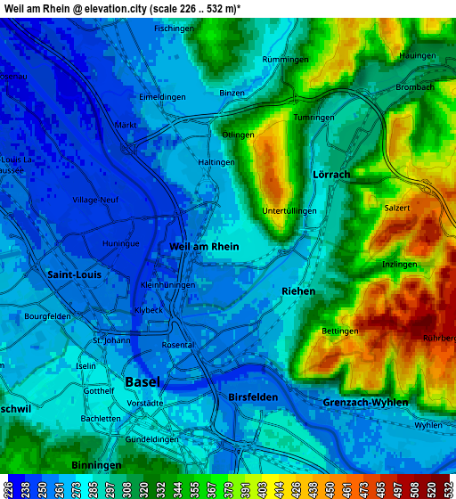
Below is the Elevation map of Weil am Rhein, which displays elevation range with different colors. Scale of the first map is from 236 to 481 m (774 to 1578 ft) with average elevation of 284 meters (=932 ft) [note 1]
These maps also provides idea of topography and contour of this city, they are displayed at different zoom levels. More info about maps, scale and edge coordinates you can find below images.

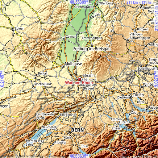
| \ | Map #1 | Map #2 | Topo.Map |
| Scale [m] | 236..481 m | 226..532 m | × |
| Scale [ft] | 774..1578 ft | 741..1745 ft | × |
| Average | 284 m = 932 ft | 302.9 m = 994 ft | × |
| Width | 6.59 km = 4.1 mi | 13.18 km = 8.2 mi | 210.9 km = 131 mi |
| Height | 6.59 km = 4.1 mi | 13.18 km = 8.2 mi | 210.9 km = 131 mi |
| ↑Max Latitude | 47.622938° | 47.652549° | 48.53309° |
| Latitude at center | 47.59331° | 47.59331° | 47.59331° |
| ↓Min Latitude | 47.563665° | 47.534004° | 46.63635° |
| ← Min Longitude | 7.576875° | 7.532929° | 6.21457° |
| Longitude center | 7.62082° | 7.62082° | 7.62082° |
| →Max Longitude | 7.664765° | 7.708711° | 9.02707° |
Nearby cities:
Cities around Weil am Rhein sort by population:
• Lörrach elevation 308 m
4.1 km,  53°
53°
• Rheinfelden 279 m
13 km,  106°
106°
• Grenzach-Wyhlen 269 m
6.7 km,  135°
135°
• Steinen 330 m
10.5 km,  57°
57°
• Efringen-Kirchen 248 m
7.5 km,  327°
327°
• Kandern 348 m
13.8 km,  13°
13°
• Maulburg 350 m
13.4 km, 64°
• Bad Bellingen 250 m
16.1 km,  342°
342°
• Binzen 282 m
4.5 km,  356°
356°
• Inzlingen 372 m
5.3 km,  95°
95°
• Eimeldingen 264 m
4.7 km, 340°
• Rümmingen 296 m
5.6 km,  16°
16°
Multilingual:
 En español:
Weil am Rhein elevación 277 m.
 En France:
Weil-am-Rhein élévation 277 m.
 Auf Deutsch:
Weil am Rhein höhe über dem Meeresspiegel ist 277 m.
 На русском:
Вайль-на-Рейне, Вайль-ам-Райн высота над уровнем моря 277 м
Sources and notes:
- [note 1] Map square and city borders are not equal. Map elevation data is calculated only from area inside that square.
- [src 1] Elevation data from geonames database provided with same terms of usage.
- [src 2] The elevation map of Weil am Rhein is generated using elevation data from NASA's 3 arcsec (90m) resolution SRTM data.
- [src 3] Base (background) map © OpenStreetMap contributors tiles are generated by Geofabrik and OpenTopoMap.
Copyright & License:
This Weil am Rhein Elevation Map is licensed under CC BY-SA. You may reuse any part from this page, if you give a proper credit by linking to this URL:
 More info on terms of use page.