Weißwasser elevation
Weißwasser (Saxony), Germany elevation is 139 meters and Weißwasser elevation in feet is 456 ft above sea level [src 1]. Weißwasser is a populated place (feature code) with elevation that is 119 meters (390 ft) smaller than average city elevation in Germany.
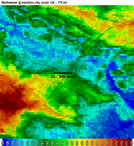
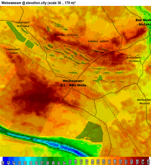
Below is the Elevation map of Weißwasser, which displays elevation range with different colors. Scale of the first map is from 124 to 179 m (407 to 587 ft) with average elevation of 143.8 meters (=472 ft) [note 1]
These maps also provides idea of topography and contour of this city, they are displayed at different zoom levels. More info about maps, scale and edge coordinates you can find below images.
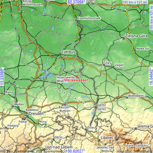
| \ | Map #1 | Map #2 | Topo.Map |
| Scale [m] | 124..179 m | 36..179 m | × |
| Scale [ft] | 407..587 ft | 118..587 ft | × |
| Average | 143.8 m = 472 ft | 136.3 m = 447 ft | × |
| Width | 6.08 km = 3.8 mi | 12.17 km = 7.6 mi | 194.7 km = 121 mi |
| Height | 6.08 km = 3.8 mi | 12.17 km = 7.6 mi | 194.6 km = 120.9 mi |
| ↑Max Latitude | 51.531376° | 51.558706° | 52.37098° |
| Latitude at center | 51.50403° | 51.50403° | 51.50403° |
| ↓Min Latitude | 51.476668° | 51.449289° | 50.62027° |
| ← Min Longitude | 14.596225° | 14.552279° | 13.23392° |
| Longitude center | 14.64017° | 14.64017° | 14.64017° |
| →Max Longitude | 14.684115° | 14.728061° | 16.04642° |
Nearby cities:
Cities around Weißwasser sort by population:
• Bad Muskau elevation 126 m
7.2 km,  44°
44°
• Krauschwitz 134 m
5.3 km,  68°
68°
• Boxberg 132 m
12 km,  201°
201°
• Rietschen 142 m
15.2 km,  139°
139°
• Schleife 131 m
8.1 km,  293°
293°
• Gablenz 142 m
3.7 km,  29°
29°
• Tschernitz 135 m
9 km,  349°
349°
• Klitten 135 m
17.2 km,  188°
188°
• Weißkeißel 124 m
5.3 km,  102°
102°
• Groß Düben 133 m
8.6 km,  323°
323°
• Uhyst 131 m
18.1 km,  210°
210°
• Trebendorf 133 m
6 km,  302°
302°
Multilingual:
 En español:
Weißwasser elevación 139 m.
 En France:
Weißwasser élévation 139 m.
 Auf Deutsch:
Weißwasser/Oberlausitz, Weißwasser höhe über dem Meeresspiegel ist 139 m.

Sources and notes:
- [note 1] Map square and city borders are not equal. Map elevation data is calculated only from area inside that square.
- [src 1] Elevation data from geonames database provided with same terms of usage.
- [src 2] The elevation map of Weißwasser is generated using elevation data from NASA's 3 arcsec (90m) resolution SRTM data.
- [src 3] Base (background) map © OpenStreetMap contributors tiles are generated by Geofabrik and OpenTopoMap.
Copyright & License:
This Weißwasser Elevation Map is licensed under CC BY-SA. You may reuse any part from this page, if you give a proper credit by linking to this URL:
 More info on terms of use page.