Wilhelmsfeld elevation
Wilhelmsfeld (Baden-Württemberg, Karlsruhe Region), Germany elevation is 440 meters and Wilhelmsfeld elevation in feet is 1444 ft above sea level [src 1]. Wilhelmsfeld is a seat of a fourth-order administrative division (feature code) with elevation that is 182 meters (597 ft) bigger than average city elevation in Germany.
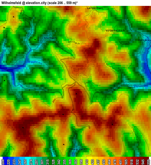
Below is the Elevation map of Wilhelmsfeld, which displays elevation range with different colors. Scale of the first map is from 206 to 559 m (676 to 1834 ft) with average elevation of 398.8 meters (=1308 ft) [note 1]
These maps also provides idea of topography and contour of this city, they are displayed at different zoom levels. More info about maps, scale and edge coordinates you can find below images.
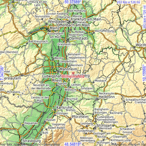
| \ | Map #1 | Topo.Map |
| Scale [m] | 206..559 m | × |
| Scale [ft] | 676..1834 ft | × |
| Average | 398.8 m = 1308 ft | × |
| Width | 6.35 km = 3.9 mi | 203.2 km = 126.3 mi |
| Height | 6.35 km = 3.9 mi | 203.2 km = 126.3 mi |
| ↑Max Latitude | 49.499109° | 50.37589° |
| Latitude at center | 49.47056° | 49.47056° |
| ↓Min Latitude | 49.441994° | 48.54819° |
| ← Min Longitude | 8.709665° | 7.34736° |
| Longitude center | 8.75361° | 8.75361° |
| →Max Longitude | 8.797555° | 10.15986° |
Nearby cities:
Cities around Wilhelmsfeld sort by population:
• Heidelberg elevation 115 m
8.3 km,  213°
213°
• Schriesheim 118 m
6.5 km,  273°
273°
• Neckargemünd 122 m
9.6 km,  161°
161°
• Edingen-Neckarhausen 105 m
10.7 km,  262°
262°
• Dossenheim 133 m
6.1 km,  248°
248°
• Ladenburg 107 m
10.5 km, 271°
• Hirschberg an der Bergstraße 105 m
8.1 km,  300°
300°
• Schönau 183 m
5.5 km,  133°
133°
• Neckarsteinach 186 m
9.6 km,  137°
137°
• Hirschhorn 130 m
10.7 km,  105°
105°
• Heiligkreuzsteinach 254 m
3.3 km,  64°
64°
• Unter-Abtsteinach 404 m
6.7 km,  20°
20°
Multilingual:
 En español:
Wilhelmsfeld elevación 440 m.
 En France:
Wilhelmsfeld élévation 440 m.
 Auf Deutsch:
Wilhelmsfeld höhe über dem Meeresspiegel ist 440 m.

Sources and notes:
- [note 1] Map square and city borders are not equal. Map elevation data is calculated only from area inside that square.
- [src 1] Elevation data from geonames database provided with same terms of usage.
- [src 2] The elevation map of Wilhelmsfeld is generated using elevation data from NASA's 3 arcsec (90m) resolution SRTM data.
- [src 3] Base (background) map © OpenStreetMap contributors tiles are generated by Geofabrik and OpenTopoMap.
Copyright & License:
This Wilhelmsfeld Elevation Map is licensed under CC BY-SA. You may reuse any part from this page, if you give a proper credit by linking to this URL:
 More info on terms of use page.