Wörrstadt elevation
Wörrstadt (Rheinland-Pfalz), Germany elevation is 208 meters and Wörrstadt elevation in feet is 682 ft above sea level [src 1]. Wörrstadt is a seat of a fourth-order administrative division (feature code) with elevation that is 50 meters (164 ft) smaller than average city elevation in Germany.
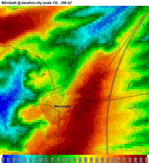
Below is the Elevation map of Wörrstadt, which displays elevation range with different colors. Scale of the first map is from 132 to 258 m (433 to 846 ft) with average elevation of 201.9 meters (=662 ft) [note 1]
These maps also provides idea of topography and contour of this city, they are displayed at different zoom levels. More info about maps, scale and edge coordinates you can find below images.
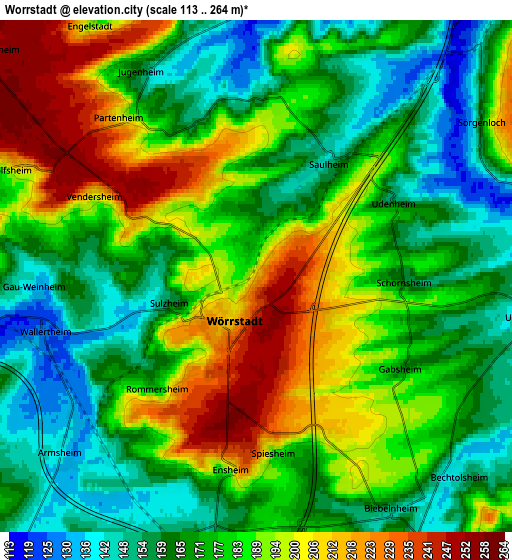
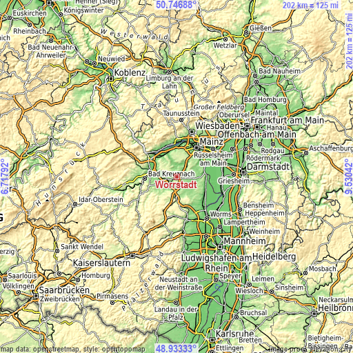
| \ | Map #1 | Map #2 | Topo.Map |
| Scale [m] | 132..258 m | 113..264 m | × |
| Scale [ft] | 433..846 ft | 371..866 ft | × |
| Average | 201.9 m = 662 ft | 179.4 m = 589 ft | × |
| Width | 6.3 km = 3.9 mi | 12.6 km = 7.8 mi | 201.6 km = 125.3 mi |
| Height | 6.3 km = 3.9 mi | 12.6 km = 7.8 mi | 201.6 km = 125.3 mi |
| ↑Max Latitude | 49.876938° | 49.905249° | 50.74688° |
| Latitude at center | 49.84861° | 49.84861° | 49.84861° |
| ↓Min Latitude | 49.820265° | 49.791904° | 48.93333° |
| ← Min Longitude | 8.080225° | 8.036279° | 6.71792° |
| Longitude center | 8.12417° | 8.12417° | 8.12417° |
| →Max Longitude | 8.168115° | 8.212061° | 9.53042° |
Nearby cities:
Cities around Wörrstadt sort by population:
• Ober-Saulheim elevation 157 m
1.9 km,  25°
25°
• Armsheim 141 m
6.5 km,  228°
228°
• Undenheim 146 m
6.9 km,  99°
99°
• Wallertheim 128 m
5.4 km,  254°
254°
• Jugenheim 160 m
5.7 km,  330°
330°
• Schornsheim 165 m
3.7 km,  94°
94°
• Partenheim 184 m
4.9 km,  322°
322°
• Bechtolsheim 144 m
7 km,  134°
134°
• Udenheim 154 m
3.8 km,  62°
62°
• Sörgenloch 153 m
6.7 km, 55°
• Sulzheim 148 m
2.4 km,  255°
255°
• Spiesheim 205 m
4.3 km,  176°
176°
Multilingual:
 En español:
Wörrstadt elevación 208 m.
 En France:
Wörrstadt élévation 208 m.
 Auf Deutsch:
Wörrstadt höhe über dem Meeresspiegel ist 208 m.

Sources and notes:
- [note 1] Map square and city borders are not equal. Map elevation data is calculated only from area inside that square.
- [src 1] Elevation data from geonames database provided with same terms of usage.
- [src 2] The elevation map of Wörrstadt is generated using elevation data from NASA's 3 arcsec (90m) resolution SRTM data.
- [src 3] Base (background) map © OpenStreetMap contributors tiles are generated by Geofabrik and OpenTopoMap.
Copyright & License:
This Wörrstadt Elevation Map is licensed under CC BY-SA. You may reuse any part from this page, if you give a proper credit by linking to this URL:
 More info on terms of use page.